This 2.5-Mile Trail In Tennessee Deserves A Spot On Your 2026 Bucket List
Some trails are worth rearranging your whole weekend for. Tennessee keeps its best hikes close to the chest, and this one is easy to overlook if you don’t know where to look.
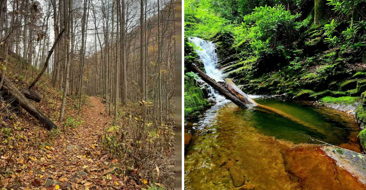
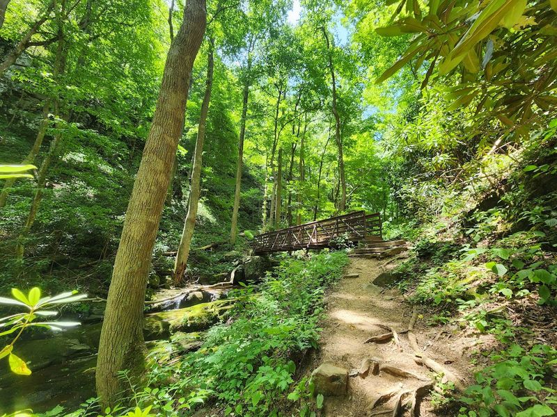
This 2.5-mile out-and-back sits inside the Cherokee National Forest near Greeneville, winding alongside a creek through fern-lined forest before arriving at a 60-foot fan-shaped waterfall.
The terrain keeps things interesting, with creek crossings, rocky stretches, and a moderate climb that feels rewarding rather than punishing.
It’s short enough to finish in a few hours, but rich enough to stay on your mind long after. If your 2026 hiking list still has room, this one belongs on it.
The Trail That Starts Easy And Gets Honest Fast
First-time visitors often smile at the beginning of this trail.
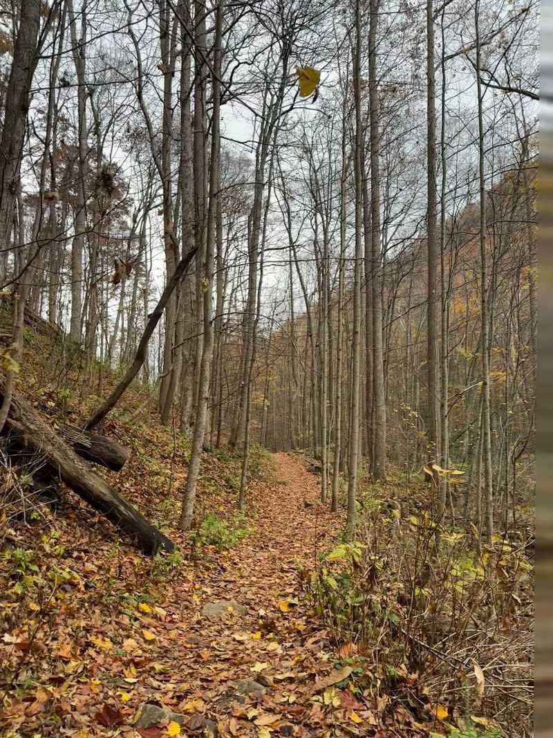
The opening stretch follows a closed Forest Service road, flat and wide, with the kind of easy footing that makes you feel like the whole hike will be a casual stroll through the woods.
That comfortable feeling lasts for about half a mile. After the trail forks and bears left toward Dry Creek, the terrain shifts its personality entirely.
Roots begin pushing through the soil, rocks crowd the path, and the incline becomes a genuine test of leg strength and patience.
One reviewer described it as a staircase built for giants, which is dramatic but not entirely wrong. The key to enjoying this section is slowing down and letting the surroundings do the work of entertaining you.
The trail rewards hikers who pace themselves and stop often to appreciate the smaller details along the way.
It is roughly 2.5 miles round trip, with an elevation gain hovering around 600 to 900 feet depending on the source. Moderate difficulty is the official rating, though your personal fitness level will shape that experience considerably.
Dry Creek And Its Parade Of Small Waterfalls
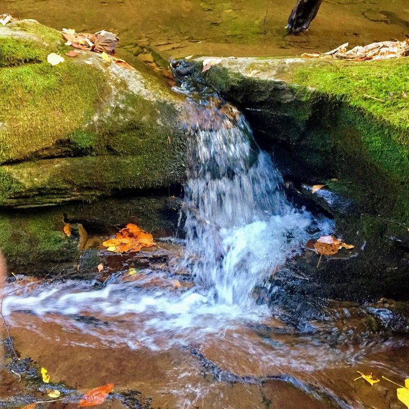
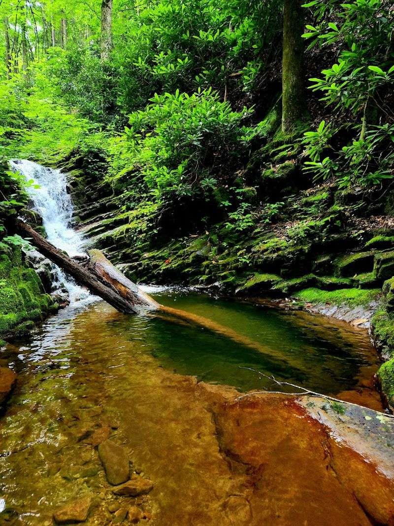
Running alongside you for most of the upper trail, Dry Creek is anything but dry.
The stream tumbles over layered rocks, splits around mossy boulders, and produces a continuous soundtrack that makes the uphill climb feel considerably more pleasant than it would in silence.
What many hikers do not expect is the number of smaller waterfalls along the route before reaching the main attraction.
These intermediate cascades appear around bends and over ledges with enough frequency that you could stop every few minutes and still feel like you are seeing something worth photographing.
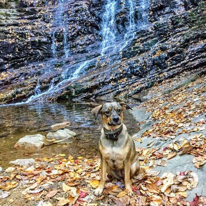
Hikers who bring dogs report that the creek access is one of the highlights for their pets.
The water is cool and clear, and there are plenty of spots where four-legged companions can wade in without any difficulty.
Leashes are required throughout the trail, which keeps the experience pleasant for everyone sharing the path.
After heavy rainfall, the creek crossings can become tricky.
Water levels rise quickly in this gorge, and the stepping stones that are simple in dry conditions can disappear entirely after a significant storm.
Checking recent trail reports before your visit is a practical habit that pays off.
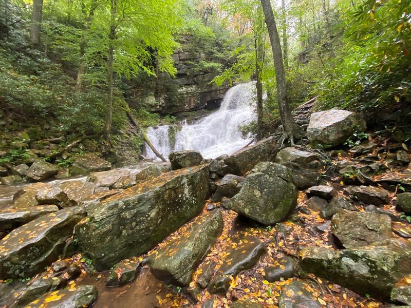
Margarette Falls: The 60-Foot Fan-Shaped Finale
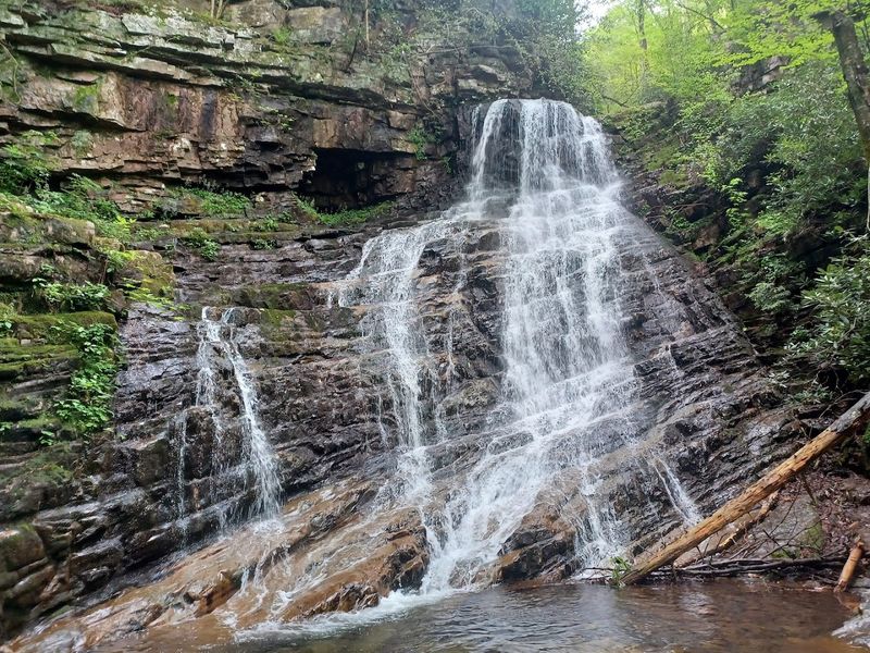
There is a particular kind of satisfaction that arrives when you round a corner and suddenly understand why you made the trip. Margarette Falls delivers that moment without hesitation.
The waterfall spreads across the rock face in a broad fan shape, which sets it apart visually from the more common ribbon-style falls found across Tennessee.
Standing at roughly 60 feet tall, the falls create a natural amphitheater of sound and mist.
The pool at the base invites you to sit and recover from the climb while the cool air rising off the water provides immediate relief, especially on humid summer days.
The rock face surrounding the falls is permanently wet and considerably slippery.
Multiple visitors have noted injuries from climbing on the rocks around the base, so admiring the falls from a safe position on stable ground is the genuinely smart approach.
The view from the designated area is already spectacular.
Named after Margaret Doak in the early 1920s, the falls carry a quiet historical identity that adds a layer of meaning to the visit.
What To Wear And Bring For A Successful Hike
Footwear is the single most important decision you will make before setting foot on Margarette Falls Trail in Greeneville. Sandals and casual sneakers are genuinely inadequate for the rocky, rooted upper section of the path.
Sturdy hiking boots with ankle support and grippy soles will protect you from rolled ankles and slipping on wet creek crossings.
Trekking poles are not strictly necessary, but hikers who bring them consistently report an easier descent. The downhill return trip is gentler than the climb, but loose rocks and damp surfaces still demand attention and balance.
A pair of lightweight poles provides meaningful stability without adding significant weight to your pack.
Water is non-negotiable. Even on cooler days, the elevation gain will push your heart rate up and leave you thirstier than expected.
Bringing at least two liters per person is a reasonable baseline, and more is always better on warm days.
Sunscreen, a light layer for the breezy summit area near the falls, snacks with some protein, and a basic first aid kit round out a practical pack.
The trail is open 24 hours every day of the week, but most visitors find that a morning start provides cooler temperatures and better lighting for photography along the creek.
The Best Seasons To Visit And What Each One Offers
Spring is arguably the most rewarding season for this trail.
Wildflowers push through the forest floor and the creek runs high and energetic from winter snowmelt. The air carries that particular freshness that only early spring delivers in the southern Appalachians.
The falls are typically at their most impressive volume during this period.
Summer draws the largest crowds, particularly on weekends and holidays.
The shade from the forest canopy makes the heat manageable, and the creek provides natural cooling stations throughout the hike.
Families with children tend to favor summer visits because the water levels are usually calm enough for safe wading in the shallower sections.
Fall transforms the trail into something quieter and more painterly.
The second-growth forest along the gorge shifts through shades of amber, rust, and gold, and the reduced foot traffic on weekday visits means you may have long stretches of trail to yourself.
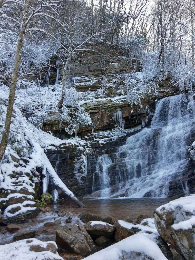
Winter is the least visited season, but it offers rewards for those willing to brave the cold. The falls can partially freeze, creating ice formations over the rock face that are genuinely striking.
Icy rocks demand extra caution, and lightweight microspikes are worth considering if temperatures have been below freezing for several days before your visit.
The Logging History That Shaped This Landscape
The land surrounding Margarette Falls was not always this quiet. In the early twentieth century, the area supported one of the largest logging operations in the region.
Timber crews worked these slopes intensively, and the old Forest Service road that forms the first half of the trail was originally built to support that industrial activity.
The forest you walk through today is second-growth, meaning it regenerated after the logging era ended. Knowing that context shifts the way you see the trees.
They are younger than they appear in spirit, and the density of the canopy represents decades of recovery rather than untouched wilderness.
The trail itself was named after Margaret Doak, a figure connected to the early 1920s era of the area’s development. That naming decision preserved a human connection to the landscape that might otherwise have been forgotten entirely as the forest reclaimed the hillsides.
The Cherokee National Forest has managed this land with a long-term conservation perspective that has allowed the ecosystem to rebuild with impressive vitality.
Walking through it with that history in mind turns a pleasant hike into something that feels genuinely layered with meaning and time.
Hiking With Kids And Dogs On This Trail
Bringing younger children on this trail requires an honest assessment of their physical capability. The first half mile is genuinely manageable for most kids, and the creek scenery keeps attention levels high.
Beyond that point, the rocky incline and rooted terrain demand more coordination and stamina than children under eight typically have.
One visitor noted that out of a group of ten hikers, only two completed the full route to the falls. That statistic is worth taking seriously when planning a family outing.
The good news is that the intermediate cascades along Dry Creek offer plenty of payoff well before the main waterfall, so turning around early does not mean the trip was wasted.
Dogs are welcome on the trail as long as they remain on a leash.
The creek access is a significant draw for water-loving breeds, and the shade along the gorge keeps temperatures reasonable even on warm days.
Bringing collapsible water bowls and extra water for your pet is a practical step that many hikers overlook.
Trekking poles or hiking sticks are especially useful for adults managing the descent while keeping one hand available for a leash or a child’s hand. Planning for a slower pace than usual will make the experience enjoyable rather than stressful for everyone involved.
Bailey Falls: The Off-Trail Reward For Experienced Hikers
For hikers who reach Margarette Falls and find themselves still energized and curious, there is an additional destination waiting further up the mountain. Bailey Falls is an off-trail waterfall that requires route-finding skills and a comfort level with unmarked terrain.
It is not a casual extension of the main hike.
Very little official information exists about the route to Bailey Falls, which is part of its appeal for experienced hikers who prefer exploration over clearly signposted paths.
The approach involves moving beyond the maintained trail system, so navigation experience and appropriate footwear become even more critical than they already are on the main route.
Visiting Bailey Falls is best reserved for those who have already completed the Margarette Falls Trail at least once and feel confident reading terrain. Going alone on an off-trail adventure in this area is inadvisable.
Bringing a hiking partner and informing someone of your planned route before departing are basic safety practices that apply here with particular urgency.
The falls themselves are described as uniquely formed, which suggests a character distinct from the fan shape of Margarette Falls.
For hikers building a deeper familiarity with the Cherokee National Forest near Greeneville, Tennessee, Bailey Falls represents a worthwhile long-term goal rather than an impulsive detour.
Practical Tips For Planning Your 2026 Visit
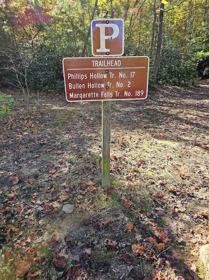
Getting to the trailhead requires a bit of navigating through rural Greene County roads.
From Highway 11E in Greeneville, take Route 107 to TN 351, travel five miles to the four-way stop, turn left on Greystone Road for about four miles, then right on Shelton Mission Road for approximately 1.3 miles.
The trailhead will appear on the right side of the road.
The parking area is spacious, with both gravel and grass sections large enough to accommodate buses and larger vehicles.
Arriving early on weekends and holidays is strongly recommended, as the lot fills quickly during peak season and the trail itself becomes noticeably more crowded by mid-morning.
The trail at Margarette Falls Trail, Greeneville, TN 37743 is open 24 hours a day, seven days a week, which technically allows for sunrise or sunset visits.
In practical terms, hiking in low-light conditions on rocky terrain adds risk, so carrying a reliable headlamp is essential if you plan to start before dawn or linger past dusk.
Cell service in the gorge can be inconsistent, so downloading an offline map before leaving home is a straightforward precaution.
Checking recent trail condition reports from other hikers on outdoor platforms will give you the most current information about creek levels, trail conditions, and any seasonal closures.