This Overlooked Nevada National Park Is Hiding 5000 Year Old Trees And Stunning Cave Formations
Most people drive straight through eastern Nevada without stopping. That is a mistake.
Hiding in a remote corner of the state sits a national park so overlooked it feels almost secret, even though it has been there for decades. Ancient trees that were already old when the pyramids were being built still stand here.
Underground chambers full of formations that took millions of years to grow wait just below the surface. High desert, alpine forests, and subterranean wonders all exist within the same 77,000 acres.
No crowds. No lines. Just one of the most quietly spectacular places Nevada has to offer, sitting patiently off the highway while everyone else rushes past. Curiosity is the only requirement.
A Nevada National Park Many Travelers Still Miss
Great Basin National Park remains one of the least visited national parks in the country, and that absence of attention works in favor of anyone who makes the trip. The park sits near the Nevada-Utah border, miles from major highways and population centers.
Most people driving across Nevada stick to Interstate 80 in the north or Las Vegas in the south, leaving this middle ground largely untouched.
The remoteness keeps visitor numbers low, which means you can hike trails, explore caves, and drive scenic roads without fighting for parking or waiting in long lines. The park receives around 90,000 visitors per year compared to millions at places like Yellowstone or Yosemite.
That solitude becomes part of the experience, allowing the landscape to speak without interruption.
Getting there requires planning, but the journey through open basin country has its own appeal. The park rewards those who venture off the beaten path with experiences that feel personal and unhurried.
Where Great Basin National Park Is Located
Great Basin National Park sits in eastern Nevada, about five miles west of the Nevada-Utah state line. The nearest town is Baker, a small community with a population that barely reaches triple digits.
From Las Vegas, the drive takes roughly five hours heading northeast, while Salt Lake City sits about four hours to the east.
Highway 50, often called the Loneliest Road in America, passes about 70 miles north of the park. From there, you turn south on Highway 487 or 893 to reach the entrance.
The landscape between major cities and the park consists of wide valleys and distant mountain ranges, the kind of terrain that makes you appreciate how much open space still exists in the American West.
The park address is simply listed as Nevada, which tells you something about how remote this place feels. Baker serves as the gateway, offering basic services and a jumping-off point for park exploration.
Why The Park Feels So Different From The Rest Of Nevada
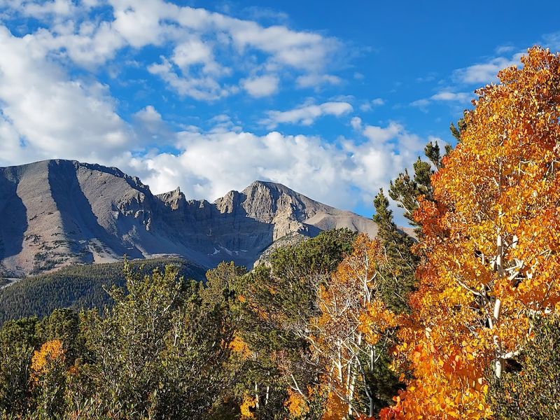
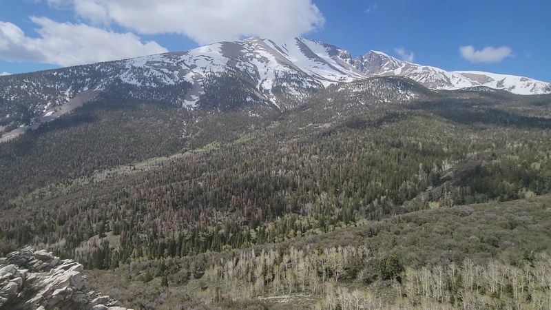
Nevada conjures images of casinos, desert heat, and endless sagebrush flats, but Great Basin National Park challenges those expectations completely. The park rises from the desert floor to over 13,000 feet at Wheeler Peak, creating climate zones that range from hot basin scrubland to cool alpine meadows.
You can start your day in temperatures pushing 90 degrees and finish it among snow patches and alpine lakes.
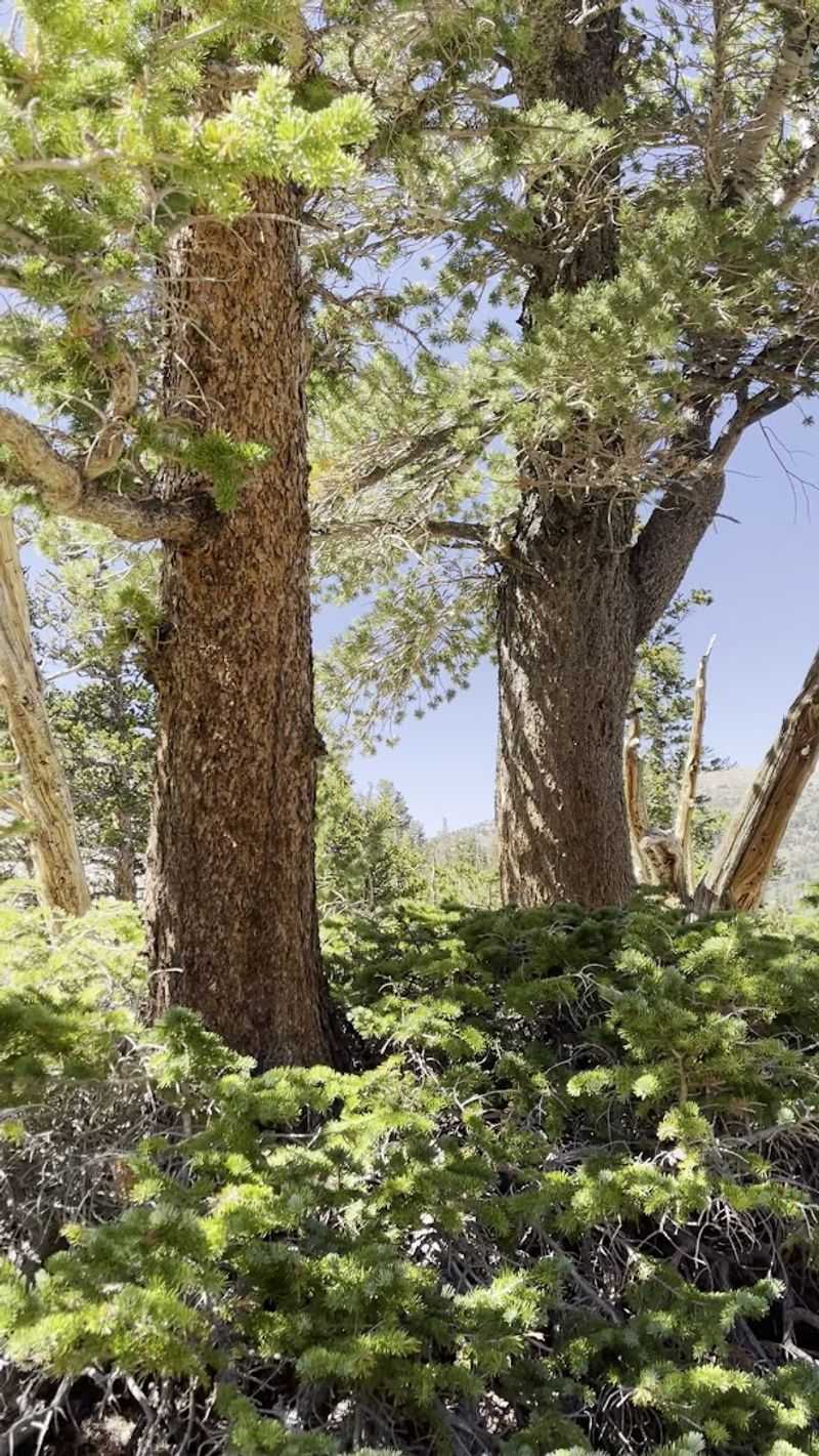
This elevation change creates ecosystems you would not expect to find in Nevada. Aspen groves turn gold in autumn, mountain streams run cold and clear, and forests of pine and fir cover the upper slopes.
The park contains one of the southernmost glaciers in the United States, a remnant of the last ice age that persists in the shadow of Wheeler Peak.
The variety makes Great Basin feel like several parks compressed into one small area, each elevation offering something different from what came before.
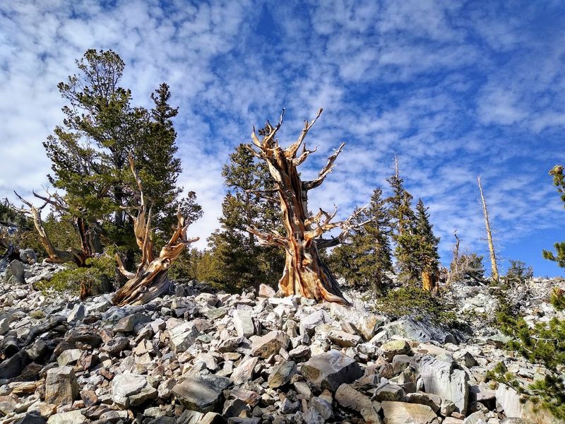
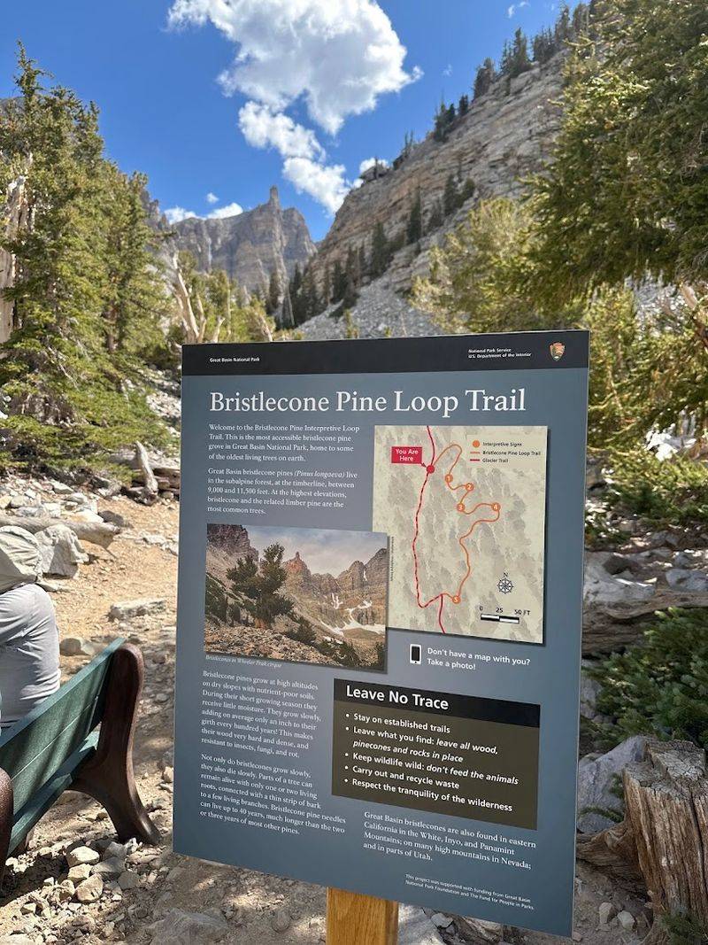
The Ancient Bristlecone Pines Are The Main Attraction
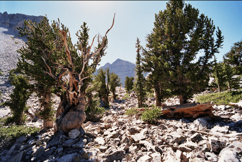
Bristlecone pines grow in harsh conditions where most trees cannot survive, and that struggle produces wood so dense and resinous it resists decay for thousands of years. Great Basin National Park protects several groves of these ancient survivors, some of which were already old when the pyramids were being built.
The trees grow slowly, adding only a fraction of an inch to their diameter each year, and their twisted forms reflect centuries of wind, cold, and drought.
Seeing a bristlecone up close changes your sense of time. The wood takes on sculptural qualities, with sections bleached white by sun and wind while other parts still support living branches and green needles.
These trees do not tower over the landscape like redwoods or sequoias; instead, they hunker down, gnarled and compact, built for endurance rather than height.
The bristlecones represent living connections to the distant past, and walking among them feels like stepping into a different era entirely.
Some Trees Have Survived For Thousands Of Years
Individual bristlecone pines in Great Basin National Park have been alive for more than 4,000 years, making them among the oldest living organisms on Earth. One tree, named Prometheus, was cut down in 1964 for research purposes and later found to be nearly 5,000 years old.
That discovery made it the oldest known non-clonal tree ever recorded, though the loss also sparked changes in how scientists study ancient trees.
The trees achieve such ages through a combination of slow growth, dense wood, and the ability to survive with only a thin strip of living tissue connecting roots to foliage. Much of the tree can be dead wood while a single vein of cambium keeps a few branches alive.
This partial die-back actually helps the tree conserve resources during droughts and harsh winters.
Standing near a tree that predates written language puts human timescales into perspective and reminds you how brief our individual lives are compared to these patient survivors.
The Wheeler Peak Grove Is The Easiest Place To See Them
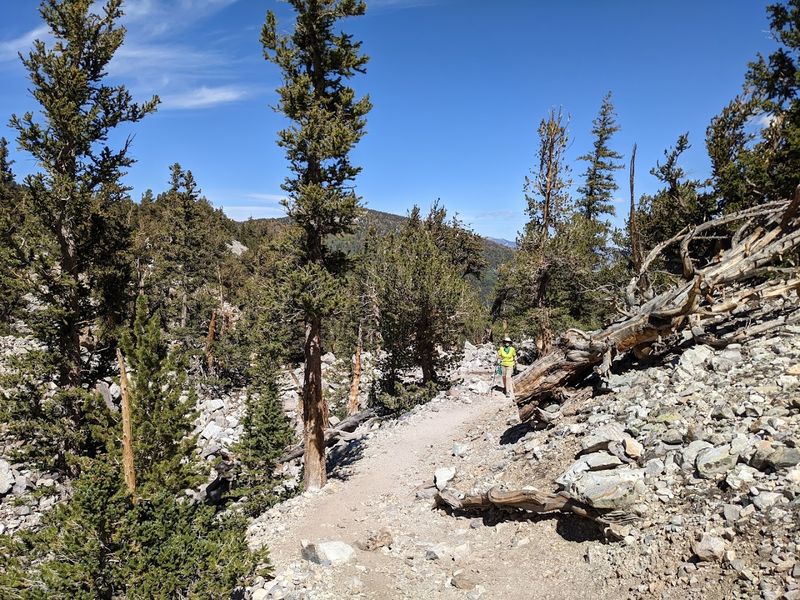
The Wheeler Peak Scenic Drive climbs to nearly 10,000 feet, where a parking area provides access to the bristlecone pine grove trail. The trail itself is relatively short, covering about three miles round trip, though the high elevation means you will feel the thin air if you are not acclimated.
The path winds through a forest of limber pines before reaching the bristlecone grove, where interpretive signs explain what makes these trees so remarkable.
The grove sits on rocky slopes where soil is thin and growing conditions are severe, exactly the kind of environment where bristlecones thrive. You can walk among dozens of ancient trees, some living, some dead but still standing, all shaped by centuries of exposure to the elements.
The views extend across the surrounding peaks and valleys, adding visual drama to the botanical interest.
Visiting during summer or early fall gives you the best chance of accessible roads and comfortable hiking conditions, though the grove remains beautiful even under snow.
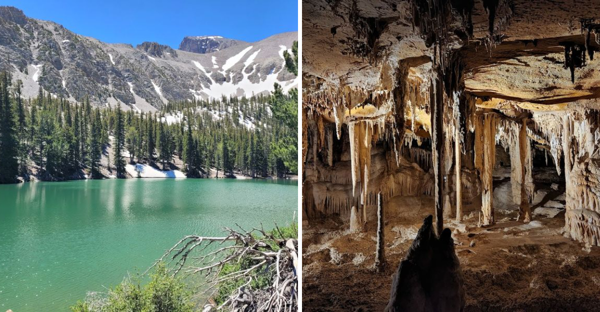
Lehman Caves Adds A Completely Different Side To The Park
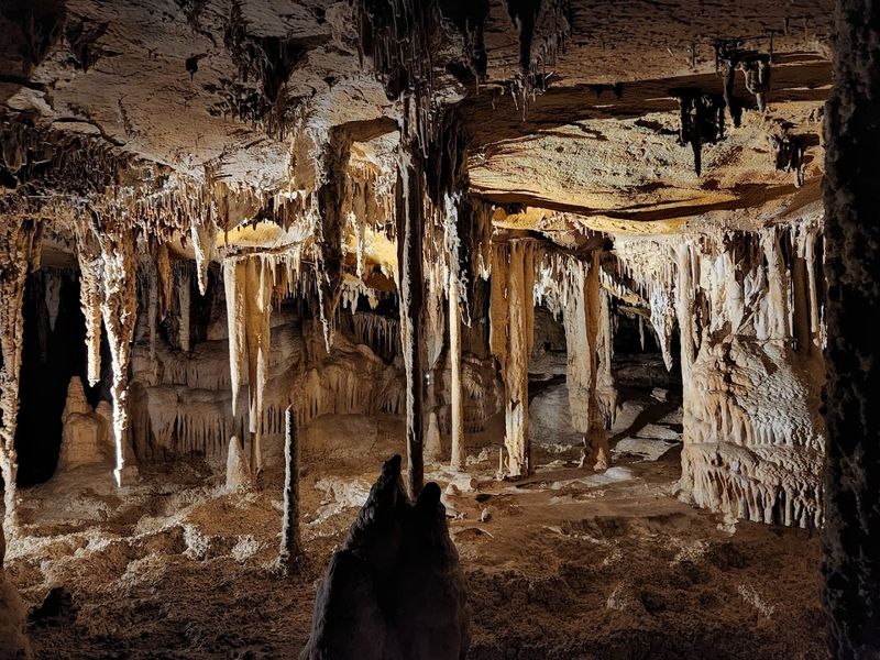
Lehman Caves sits beneath the park surface, a limestone cavern system discovered in the 1880s by rancher Absalom Lehman. The caves formed over millions of years as water dissolved the surrounding rock and deposited minerals in intricate formations.
Tours take visitors through a series of chambers where the temperature holds steady around 50 degrees year-round, a welcome break from summer heat or winter cold.
The National Park Service leads guided tours that last about 90 minutes, covering roughly half a mile of underground passages. Reservations are strongly recommended, especially during summer months when tours fill quickly.
The guides provide context about cave formation, history, and the delicate balance required to preserve the underground environment while allowing public access.
Adding a cave tour to your visit creates contrast with the above-ground landscapes, showing yet another facet of what makes Great Basin National Park so diverse and interesting.
The Cave Is Filled With Stalactites, Stalagmites, Popcorn, And Cave Shields
Inside Lehman Caves, mineral deposits have created an impressive variety of formations that demonstrate different processes of cave development. Stalactites hang from the ceiling like stone icicles, formed by water dripping and leaving behind tiny amounts of calcite with each drop.
Stalagmites grow upward from the floor where those drops land and deposit more minerals. In some places, the two formations meet to create columns that span floor to ceiling.
Cave shields are rarer features that look like thin plates of rock projecting from walls or ceilings, formed when water seeps between rock layers and deposits minerals along the crack. Popcorn formations cover surfaces with knobby, bumpy textures that resemble their namesake.
The caves also contain flowstone, draperies, and helictites, each representing a different chapter in the cave’s ongoing formation.
The lighting installed along the tour route highlights these features without overwhelming them, allowing you to appreciate the scale and detail of formations that took countless centuries to develop.
Wheeler Peak Gives The Park Its Dramatic Mountain Backdrop
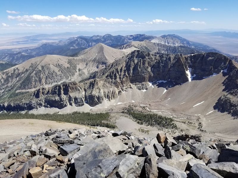
Wheeler Peak rises to 13,065 feet, making it the second-highest mountain in Nevada and the centerpiece of Great Basin National Park. The peak dominates the skyline from almost anywhere in the park, its summit often holding snow well into summer.
The mountain provides more than just scenery; it creates the elevation gradient that allows such diverse ecosystems to exist in a relatively small area.
Climbing Wheeler Peak requires a strenuous hike that gains about 3,000 feet over roughly four miles, starting from the upper parking area on the scenic drive. The trail passes through forest, crosses alpine meadows, and eventually reaches barren, rocky slopes near the summit.
Weather can change quickly at high elevation, so preparation matters even in summer.
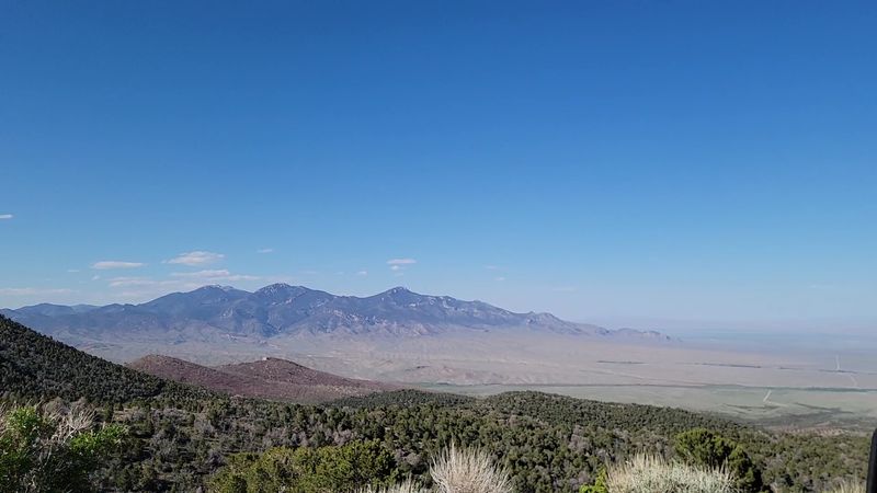
From the top, views extend in all directions across Nevada and into Utah, with basin and range topography stretching to the horizon. The peak gives the park its vertical drama and serves as a focal point for many of the park’s best hikes and viewpoints.
The Scenic Drive Climbs Into A Cooler Alpine World
The Wheeler Peak Scenic Drive starts near the visitor center and climbs roughly 12 miles to an elevation just under 10,000 feet. The paved road winds through different vegetation zones, beginning in sagebrush and pinyon-juniper woodland before entering forests of aspen, pine, and fir.
Several pullouts along the way offer views back across the valley and toward distant mountain ranges.
The drive itself takes about 40 minutes one way if you do not stop, but the pullouts and changing scenery make it worth taking your time. As you climb, temperatures drop noticeably, often by 20 or 30 degrees compared to the valley floor.
The upper portions of the road may close in winter due to snow, typically from late fall through late spring.
At the top, parking areas provide access to trailheads for bristlecone pines, alpine lakes, and Wheeler Peak itself. The scenic drive concentrates much of the park’s best features into a single accessible route.
Hiking Trails Lead To Lakes, Forests, And Big Views
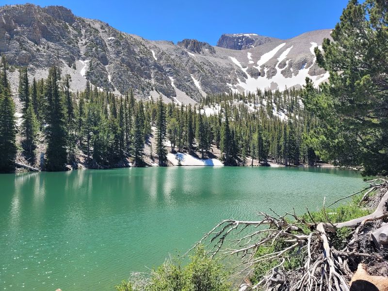
Great Basin National Park maintains a network of trails that range from easy nature walks to demanding summit climbs. The Alpine Lakes Loop Trail is a moderate option that visits Stella Lake and Teresa Lake, both set in cirques carved by ancient glaciers.
The trail covers about three miles and stays above 10,000 feet, offering views of Wheeler Peak and surrounding ridges.
For easier walks, the trails near Lehman Caves and the lower visitor center provide access to riparian areas and desert landscapes without significant elevation gain. The Osceola Ditch Trail follows an old water channel built by miners in the 1800s, offering history along with scenery.
More ambitious hikers can tackle the Wheeler Peak summit trail or routes that lead to the glacier and other high-altitude features.
Trail conditions vary by season, with snow lingering on higher routes well into summer. The variety of trails means you can find options suited to your fitness level and available time while still experiencing the park’s diverse landscapes.