This Easy Nevada Hike Ends At A 60-Foot Waterfall And The Views Along The Way Are Unreal
Desert highways and casino lights may dominate Nevada’s reputation, yet the mountains near Lake Tahoe have other plans. A high-elevation path crosses open meadows, skirts forested slopes, and reveals broad views of blue water and rugged peaks.
The route feels manageable at first, though the thin air may make your lungs disagree. Wildflowers brighten the landscape during summer, while lingering snow can complicate early-season visits.
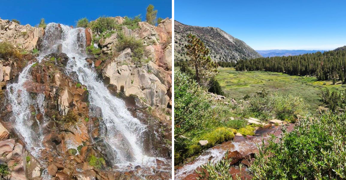
After roughly two and a half miles, rushing water appears against a red rock face. The cascade tumbles roughly 60 feet, creating a finale that looks almost borrowed from another state.
Bring sturdy shoes, extra water, and enough time to enjoy every unexpected side of Nevada along the way without rushing back to the car.
The Adventure Begins Near 9,000 Feet Above Sea Level
Starting your hike at nearly 9,000 feet means the air feels thinner from the first step. The Mount Rose Summit trailhead sits along Nevada State Route 431, positioned between Reno and Lake Tahoe in a location that offers immediate relief from valley heat.
Parking fills quickly during summer weekends, so arriving early gives you both a spot and cooler morning temperatures.
Altitude affects everyone differently, and beginning at this elevation means your body works harder than it would at sea level. Some hikers notice the difference immediately while others adapt without issue.
The trailhead facilities include restrooms and clear signage directing you toward the Tahoe Rim Trail section that leads to Galena Falls.
High elevation hiking rewards you with cooler temperatures and stunning clarity. On clear days, the atmosphere at this altitude creates visibility that stretches for miles across mountain ranges and valleys below.
The Waterfall Sits About 2.4 Miles From The Trailhead
Covering 2.4 miles sounds manageable on paper, but elevation and terrain always add complexity to mountain trails. The distance to Galena Falls makes this an achievable goal for most fitness levels without requiring an entire day commitment.
Round trip totals just under five miles, leaving time for waterfall viewing and photography without rushing.
Trail conditions vary throughout the season as snowmelt patterns shift and weather changes the landscape. Early summer often provides the most dramatic waterfall flow, though the path may still hold snow patches in shaded areas.
Late summer and fall bring drier conditions with less impressive water volume but easier navigation.
Pacing becomes important when hiking at altitude, even on relatively short distances. What feels like a quick walk at lower elevations demands more breaks and slower progress near 9,000 feet.
The trail rewards patience with continuous scenery changes that make frequent stops worthwhile beyond just catching your breath.
A Gentle Opening Climb Quickly Reveals Tahoe Meadows
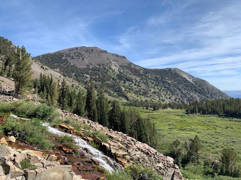
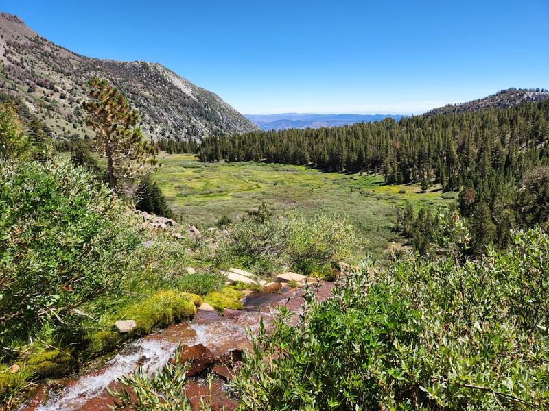
The trail wastes no time delivering visual rewards as you climb away from the parking area. Within the first half mile, Tahoe Meadows spreads out in a display of high altitude grassland ecology that shifts with the seasons.
Summer transforms this area into a wildflower showcase while spring reveals wetland characteristics from snowmelt.
Meadow ecosystems at this elevation support plant communities adapted to short growing seasons and harsh winters. The openness provides unobstructed views in multiple directions, creating a sense of spaciousness rare on forested mountain trails.
Birds and small mammals frequent the meadow edges where vegetation meets tree line.
Photographers find endless compositions here as light changes throughout the day across the meadow grasses. Morning sun illuminates the eastern slopes while afternoon rays create golden tones across the western ridges.
The meadow section offers relatively flat walking before the trail begins its more varied terrain toward the falls.
Lake Tahoe Views Appear Before You Reach The Falls
Lake Tahoe announces itself through gaps in the forest long before you arrive at any official viewpoint. The brilliant blue water contrasts sharply with surrounding evergreens and granite peaks, creating scenes that stop hikers in their tracks.
These glimpses come and go as the trail winds through varying terrain and vegetation density.
The lake sits at 6,225 feet elevation, nearly 3,000 feet below your hiking path, which creates a bird’s eye perspective unavailable from shoreline locations. This elevated vantage point reveals the lake’s massive scale and surrounding mountain geography in ways that lakeside visitors never experience.
Clear days allow you to distinguish California peaks on the western shore.
Timing your hike for optimal light enhances the lake views considerably. Midday sun can create glare that washes out the famous blue color, while morning and late afternoon light brings out deeper tones and better definition of the shoreline features below.
Most Of The Route Follows A Scenic Section Of The Tahoe Rim Trail
The Tahoe Rim Trail stretches 165 miles around Lake Tahoe, and the section leading to Galena Falls ranks among its most accessible segments. This portion maintains the quality construction and thoughtful routing that makes the entire TRT system popular with both day hikers and backpackers.
Trail maintenance keeps the path clear of major obstacles while preserving its natural character.
Following an established long-distance trail provides confidence in navigation and path quality. The TRT sees enough traffic to stay well-defined without becoming overcrowded or eroded.
Junctions with connecting trails feature clear signage indicating distances and destinations, reducing confusion about which direction leads toward the falls.
Sharing trail space with through-hikers occasionally adds interesting encounters to your day hike. These long-distance travelers often carry full backpacking gear and stories from other sections of the route.
The well-graded trail allows comfortable walking that lets you appreciate surroundings rather than constantly watching foot placement on rough ground.
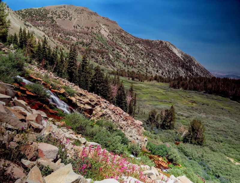
Wildflower Meadows Bring Brilliant Color During Summer
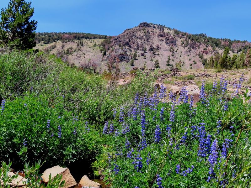
Summer transforms the high elevation meadows into botanical displays that rival cultivated gardens. Lupine, paintbrush, mule ears, and dozens of other species create color combinations that change week by week as different plants reach peak bloom.
The short growing season concentrates flowering into a compressed window that makes timing crucial for peak displays.
Peak wildflower season typically arrives in late June through July, though heavy snow years can push the calendar later. Snowmelt patterns determine when meadow soils warm enough for germination and growth to begin.
Checking recent trip reports helps predict current conditions better than fixed calendar dates.
The variety of elevation zones along the trail means flowers bloom at different times in different locations. Lower sections may finish flowering while higher meadows just begin their display.
This staggered timing extends the overall wildflower season and ensures some color throughout most of summer, even if individual meadows peak for just a few weeks.
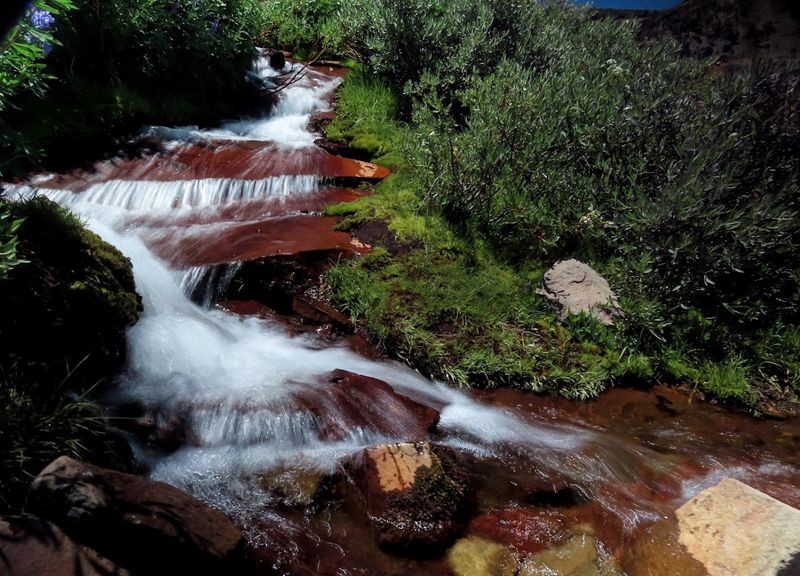
Tamarack Lake And Galena Canyon Add Drama To The Journey
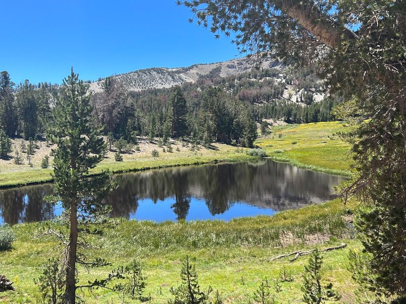
The landscape surrounding Galena Falls includes geographical features that extend beyond just the waterfall itself. Tamarack Lake sits in a glacially carved basin that demonstrates the ice age forces that shaped this entire region.
The canyon walls rise dramatically from the creek, creating a sense of enclosure that contrasts with the open meadow sections earlier on the trail.
Galena Canyon channels snowmelt from surrounding peaks into the drainage that feeds the falls. The red-tinted rock formations give the area distinctive coloring different from typical Sierra granite.
Geological diversity makes the scenery more interesting than simple forest walking, with rock outcrops and cliff bands adding vertical dimension.
Exploring beyond the main waterfall viewpoint reveals additional perspectives on the canyon and surrounding topography. Side paths and use trails branch toward different vantage points, though staying on established routes protects fragile alpine vegetation.
The canyon environment creates microclimates that support plant communities different from exposed ridge sections of the trail.
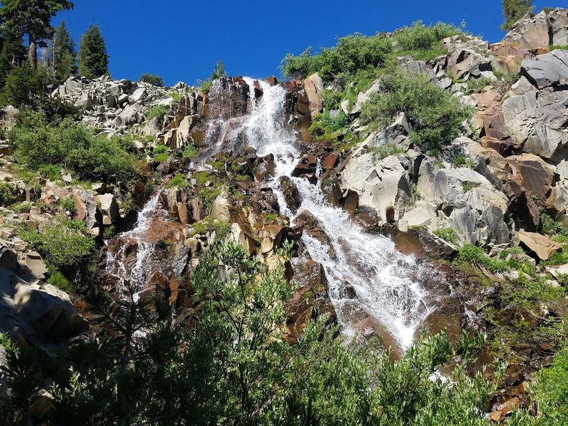
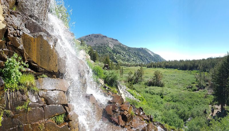
The Waterfall Spreads Across A Wide Red Rock Face
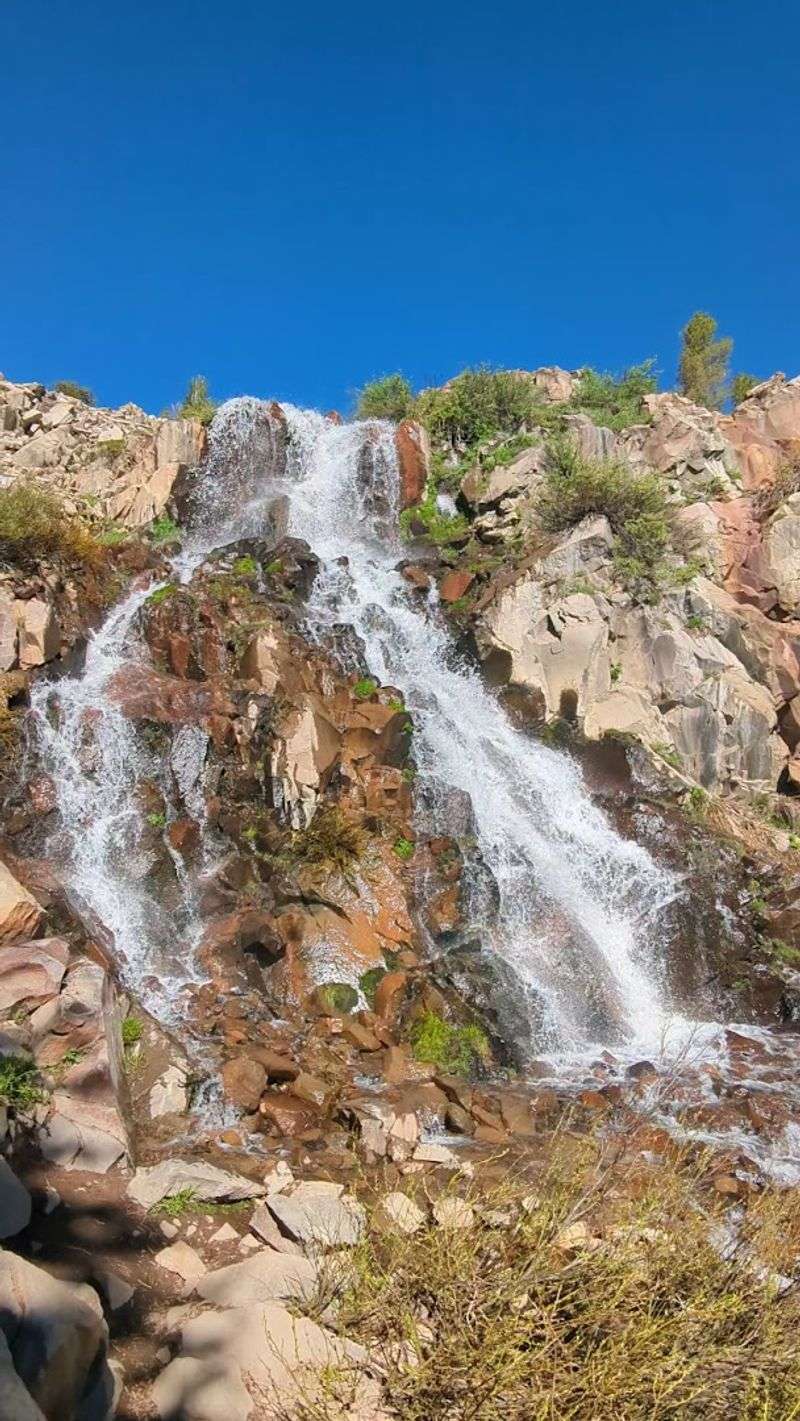
Galena Falls defies expectations by spreading horizontally across a broad rock face rather than plunging in a narrow column. The waterfall spans perhaps 30 feet wide during peak flow, creating a curtain effect as water sheets down the reddish rock.
This spreading pattern makes the falls visually distinctive from typical mountain waterfalls that concentrate flow into single channels.
The red rock coloring comes from iron-rich minerals in the local geology, creating a backdrop that enhances the white water contrast. Sunlight on the wet rock surface brings out orange and rust tones that vary throughout the day.
The wide rock face allows multiple viewing angles, each revealing different patterns in how water moves across the stone.
Approaching the base requires careful footing on rocks that stay perpetually damp from spray and runoff. The amphitheater-like setting concentrates the sound of falling water into a constant roar during high flow periods.
Standing near the base provides cooling mist on warm days while surrounding rocks offer seating for extended viewing.
Snowmelt Determines How Powerful The Cascade Looks
The waterfall’s appearance changes dramatically between seasons based entirely on available water volume. Spring and early summer bring maximum flow as accumulated snowpack melts from surrounding peaks and slopes.
Heavy snow years create spectacular displays that continue well into July, while light snow winters result in diminished flows that may reduce to trickles by August.
Checking snowpack data before your hike helps set realistic expectations for waterfall conditions. The Natural Resources Conservation Service maintains snow monitoring stations throughout the Sierra Nevada that provide current data on snow water equivalent.
Recent visitor reports on hiking websites offer firsthand accounts of current waterfall volume.
Late season visits trade waterfall drama for easier trail conditions and smaller crowds. September and October bring nearly dry falls but also stable weather, no snow on the trail, and solitude that summer never provides.
Each season offers different advantages, and understanding the tradeoffs helps you choose the best timing for your priorities and interests.
Short Steep Sections Make The Hike More Challenging Than Expected
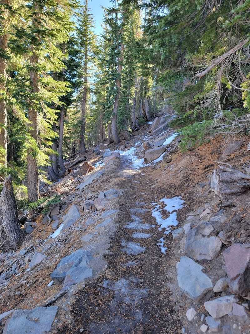
Calling this an easy hike oversimplifies the reality of mountain terrain at high elevation. While the overall distance remains modest and total elevation gain stays reasonable, several sections demand more effort than the easy label suggests.
Rocky steps, short steep pitches, and loose tread require attention and proper footwear for safe passage.
The initial climb from the trailhead gains elevation quickly before settling into gentler grades. These opening switchbacks get your heart rate up and remind you that easy is a relative term in mountain environments.
Later sections include shorter climbs and descents that break up the walking rhythm and engage different muscle groups.
Trail conditions vary with season and recent weather, adding unpredictability to difficulty assessments. Spring mud, summer dust, or early fall ice each create different traction challenges.
The combination of altitude, terrain variation, and distance makes this hike genuinely moderate for most people despite its reputation as an easy walk to a waterfall.