The Secret Utah Desert Roads That Lead To Total Solitude
Utah’s desert landscapes hold secrets that most travelers never discover.
Beyond the crowded viewpoints and paved scenic drives, a network of remote dirt roads winds through red rock canyons, ancient plateaus, and vast stretches of wilderness where silence becomes your closest companion.
These hidden routes offer something rare in our noisy world: complete solitude, where you can drive for hours without seeing another soul, surrounded only by the raw beauty of the desert.
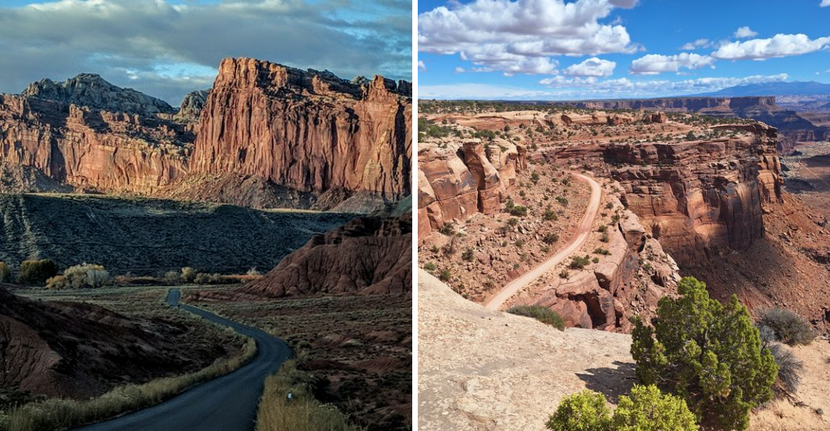
1. Potash Road (Moab Area / Canyonlands National Park)
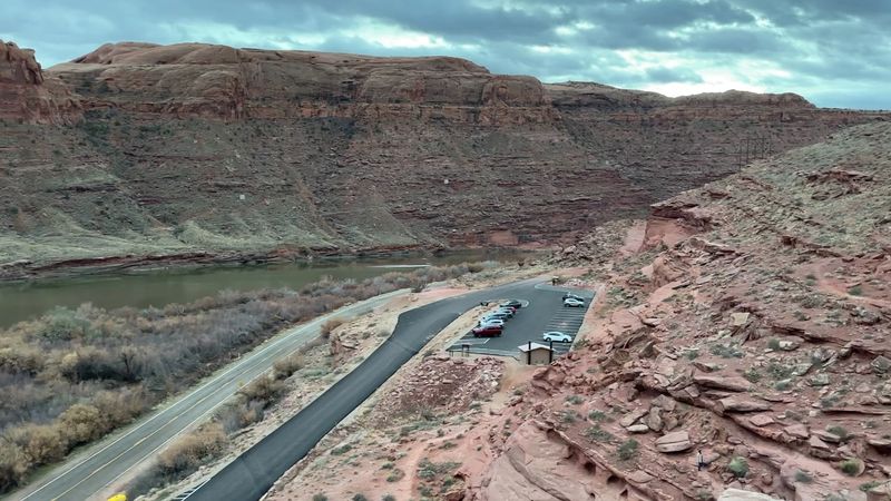
Following the Colorado River downstream from Moab, this paved-then-dirt route transforms from tourist corridor to isolated wilderness road.
The first miles pass beneath towering Wingate cliffs adorned with ancient petroglyphs—watch for the rock art panels on your right, etched by peoples who traveled these canyons centuries before us.
Once the pavement ends at the potash mine, the character shifts completely.
The road narrows and roughens, hugging the riverbank as it penetrates deeper into the canyon system.
Cottonwoods provide occasional shade, their leaves catching the breeze off the water.
You’ll likely see rafters floating past, but vehicular traffic drops to nearly nothing beyond the mine.
The silence here feels textured, broken only by the river’s whisper and the occasional raven’s call echoing off sandstone walls.
This route eventually connects to the White Rim Trail, but most visitors turn around before then, content to simply absorb the solitude of this riverside sanctuary where red rock meets flowing water.
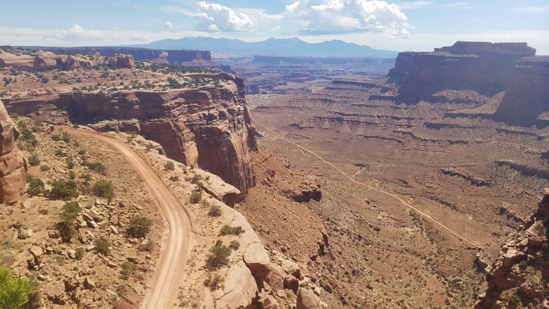
2. Shafer Trail (Canyonlands National Park)
Carved into the canyon walls by uranium miners in the 1950s, this switchback-laden route drops 1,400 feet in just a few miles.
Your vehicle will hug the cliff edge as you descend through layers of geologic history, each hairpin turn revealing more of the Colorado River valley below.
The exposure feels real and raw—there are no guardrails here, just you and the ancient sandstone.
Most park visitors never venture beyond the paved overlooks above, which means this road stays wonderfully empty.
You’ll wind through formations that look like melted caramel, passing beneath towering walls striped with desert varnish.
High-clearance vehicles are recommended, though the road is usually passable for sturdy cars in dry conditions.
Check weather forecasts carefully—rain turns the clay surface into slick, impassable gumbo.
The entire descent takes about an hour, but you’ll want to stop frequently to absorb the views and the profound quiet that settles over these canyons like dust.
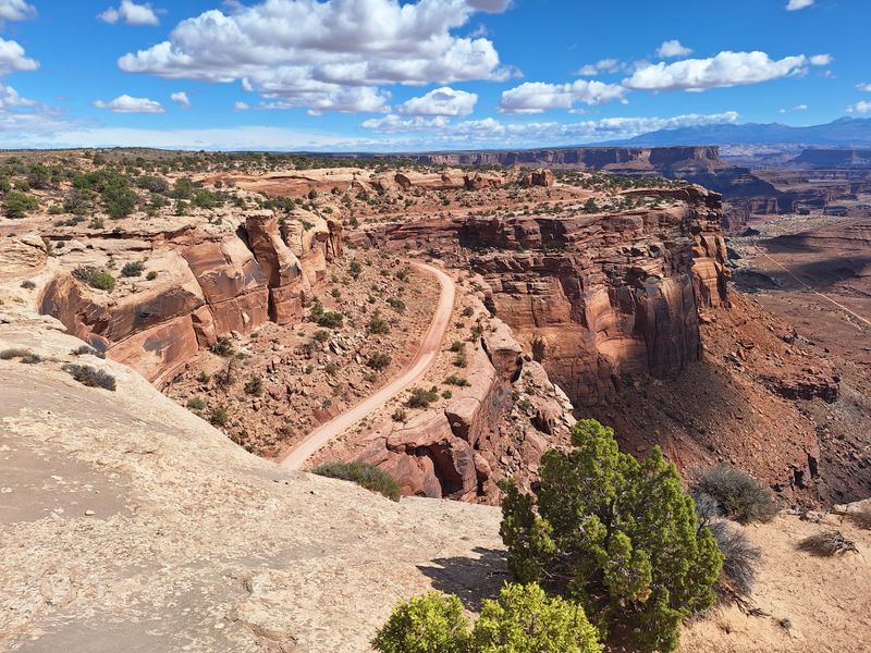
3. Mineral Bottom Road (Canyonlands National Park)
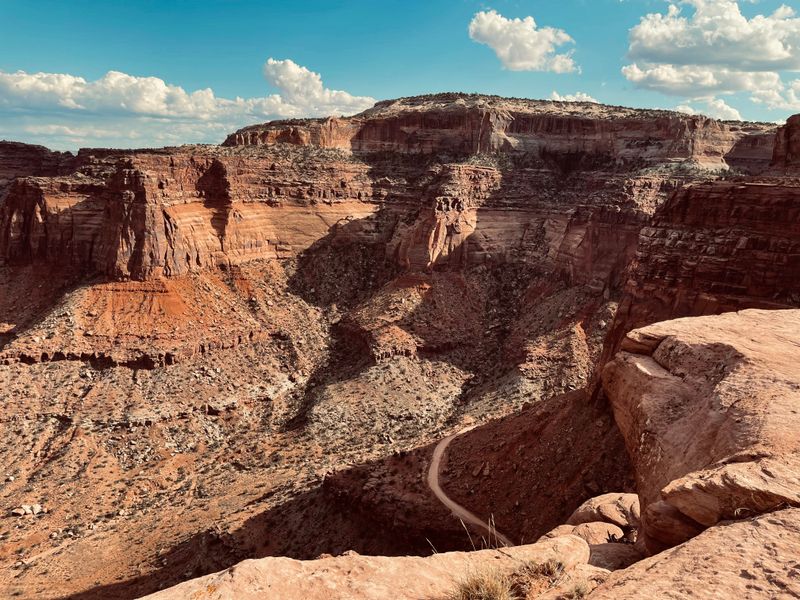
Branching off Highway 313, this rough track plunges toward the Green River through a landscape that feels utterly forgotten.
The descent is steep and technical, requiring four-wheel drive and nerves steady enough to handle exposed sections where the road narrows to barely wider than your vehicle.
Rocks jut from the surface like broken teeth, testing your suspension and your commitment.
But those challenges create the isolation that makes this route special.
You won’t encounter RVs or casual sightseers here—just serious adventurers and the occasional river party using the boat launch at road’s end.
The views open up as you drop elevation, revealing the Green River’s lazy curves through Labyrinth Canyon.
Mineral Bottom itself is a grassy riverside flat where pioneers once grazed cattle, now returned to wilderness.
Camp here if you have time, and watch stars emerge in numbers impossible to see from populated areas.
The silence at night is so complete you can hear your own heartbeat.
4. White Rim Road (Canyonlands National Park)
This hundred-mile loop circles the Island in the Sky mesa on a benchland suspended between canyon layers.
Driving it feels like traversing another planet—the White Rim sandstone forms a pale platform beneath towering cliffs above and plunging depths below.
The scale is overwhelming, the isolation absolute.
Most people tackle this route as a multi-day trip, camping at designated sites along the way.
The road itself is relatively smooth by backcountry standards, but it’s the remoteness that challenges you.
There’s no cell service, no water sources, no rescue nearby if things go wrong.
You’re truly on your own.
The rewards match the commitment.
Sunrise paints the canyon walls in shades photographers dream about.
Midday heat shimmers off the white rock, creating mirages.
Evening brings relief and colors that seem impossible.
You’ll share this space with bighorn sheep and ravens, but human encounters are rare.
Permits are required and limited, which preserves the solitude that makes this journey unforgettable.
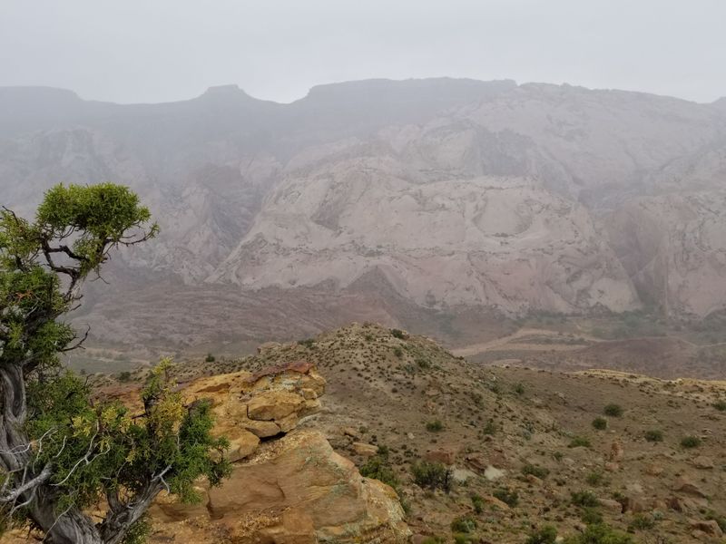
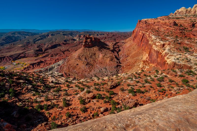
5. Notom–Bullfrog Road (Capitol Reef National Park)
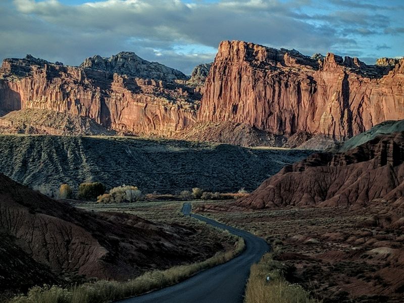
Stretching seventy miles along the eastern flank of the Waterpocket Fold, this mostly graded dirt road reveals Capitol Reef’s wild side.
The pavement ends just south of the park’s main area, and suddenly you’re alone with one of Earth’s most dramatic geologic features—a massive wrinkle in the planet’s crust that rises like a stone wave.
The road parallels this formation for its entire length, offering constantly changing perspectives.
Side canyons beckon for exploration—Burro Wash, Cottonwood Wash, and others where slot canyons hide between the folds.
Traffic is sparse even in peak season.
The landscape shifts as you drive south, from pinyon-juniper highlands to increasingly barren desert.
By the time you reach Bullfrog Marina on Lake Powell, you’ve crossed through multiple ecosystems and countless millions of years of exposed geology.
The solitude here is profound, broken only by the wind and the occasional hawk riding thermals above the Fold.
Bring plenty of water and fuel—services are nonexistent along this remote corridor.
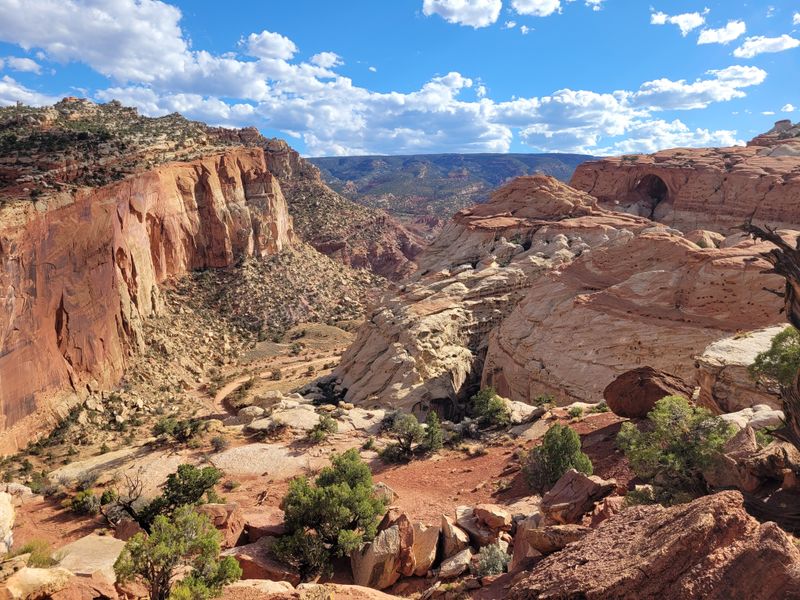
6. Burr Trail (Capitol Reef National Park)
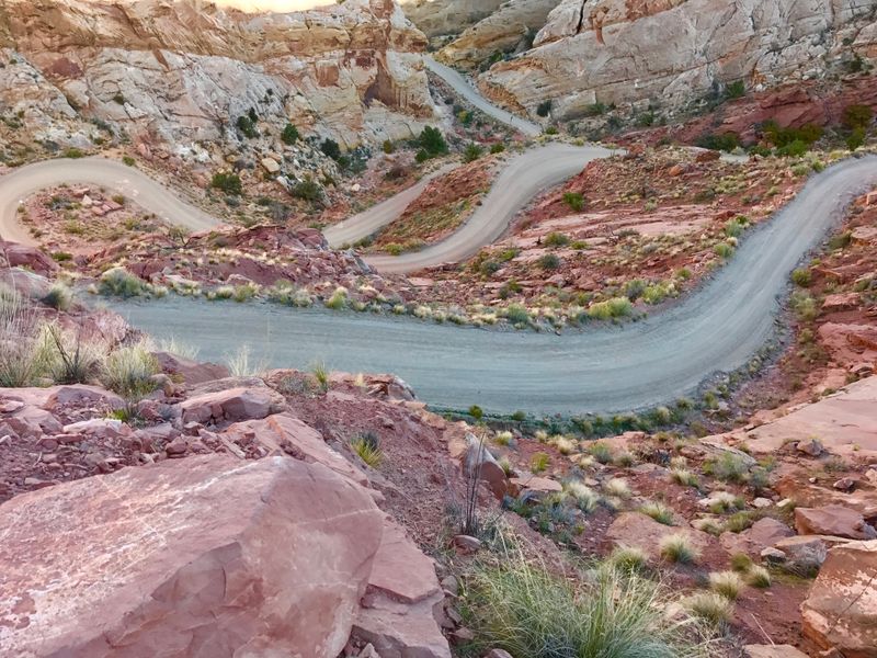
Starting near Boulder, this route transitions from pavement to dirt as it crosses Capitol Reef’s Waterpocket District.
The switchbacks descending the Burr Trail are legendary—a series of steep, graded curves that drop you from the plateau into Long Canyon like a stone spiral staircase carved into the cliff face.
Your hands will grip the wheel tightly as you navigate these turns, but the engineering is solid and the views are staggering.
Below, Long Canyon opens up in shades of cream and rust, its walls rising hundreds of feet on either side.
Beyond the switchbacks, the road mellows as it follows the canyon floor eastward.
This section sees more traffic than some routes on this list, but it’s still remarkably quiet compared to paved park roads.
Side hikes lead to slot canyons and natural arches.
The geology here tells stories of ancient seas and desert dunes compressed into stone, then uplifted and carved by water.
It’s a landscape that demands your attention and rewards your solitude-seeking soul.
7. Strike Valley Overlook Road (Capitol Reef National Park)
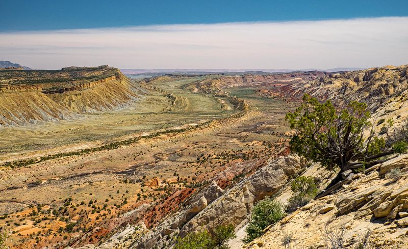
Few visitors even know this spur exists, branching off from the Notom Road to climb toward a viewpoint that reveals the full majesty of the Waterpocket Fold.
The road is rough and rocky, suitable only for high-clearance vehicles, which keeps the crowds away and the experience intimate.
As you climb, the perspective shifts dramatically.
What appears as a simple ridge from below reveals itself as a massive geologic upheaval, a hundred-mile-long monocline that buckled upward millions of years ago.
Strike Valley runs along the fold’s eastern base like a seam in the earth’s fabric.
The overlook itself sits at road’s end, a windswept point where you can stand and see dozens of miles in every direction.
The silence here is profound—no engines, no voices, just wind and the vast openness of the Colorado Plateau.
Bring binoculars to spot distant landmarks: the Henry Mountains to the east, the red cliffs of Capitol Reef to the west.
This is solitude at its most spectacular, where the scale of the landscape makes you feel wonderfully small.
8. Halls Creek Overlook Road (Capitol Reef National Park)
Another obscure spur off the Notom-Bullfrog Road, this track leads to an overlook above Halls Creek Narrows, one of the park’s most remote and beautiful slot canyons.
The road requires high clearance and careful navigation—ruts and rocks make this a slow, attentive drive.
But that difficulty is your reward.
You’ll have this place almost entirely to yourself, standing at the rim looking down into a sinuous crack in the earth where Halls Creek has carved its patient way through Navajo sandstone.
The walls glow in shades of orange and pink, and the depth is dizzying.
Backpackers sometimes venture into the narrows below, but you’re unlikely to spot them from above.
The overlook offers a bird’s-eye perspective on wilderness that few humans ever enter.
Hawks circle below you, riding updrafts from the canyon depths.
The silence is broken only by wind whistling across the rim.
This is the kind of place that restores something essential in the soul—a reminder that wild, empty places still exist if you’re willing to seek them out.
9. Hartnet Road (Capitol Reef National Park)
Accessing Cathedral Valley requires commitment, and Hartnet Road is one of two routes into this remote district.
Starting from Highway 24, the road immediately crosses the Fremont River—a ford that can be impassable during spring runoff or after storms.
Check conditions before attempting this crossing.
Beyond the river, the road climbs onto Hartnet Bench, a high plateau of sage and juniper where pronghorn antelope outnumber people.
The solitude here is immediate and total.
You might drive for hours without seeing another vehicle, surrounded only by endless sky and rolling desert.
The road surface alternates between graded dirt and rocky sections that require careful tire placement.
It’s slow going, but that’s part of the experience—this landscape demands you move at its pace, not yours.
Eventually, you’ll connect with Cathedral Valley Road, but the journey itself is the destination.
Watch for wildlife: eagles perched on fence posts, coyotes trotting across the flats, even the occasional bobcat.
This is backcountry Utah at its most authentic and isolated.
10. Cathedral Valley Road (Capitol Reef National Park)
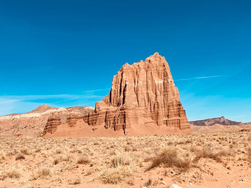
The main route through Cathedral Valley loops through some of the most alien-looking terrain in Utah.
Massive monoliths of Entrada sandstone rise from the valley floor like ancient temples—the Temple of the Sun and Temple of the Moon are the most famous, their forms so perfect they seem sculpted by design rather than erosion.
The loop is about sixty miles, requiring a full day and a capable vehicle.
The road crosses several washes that can be treacherous when wet, and there’s no cell service or assistance if you get stuck.
That isolation is precisely what makes this journey magical.
You’ll pass through landscapes that shift from badlands to grasslands to stone forests.
The colors range from deep burgundy to pale cream, changing with the light.
Camp at one of the primitive sites and you’ll experience night skies that blaze with stars, the Milky Way so bright it casts shadows.
Morning light on the monoliths is ethereal, otherworldly.
This is solitude of the highest order—vast, beautiful, and utterly unforgettable.
11. Oil Well Bench Road (Capitol Reef National Park)
Connecting Highway 24 to Cathedral Valley from the north, this alternative access route traverses Oil Well Bench, a high mesa named for unsuccessful petroleum exploration decades ago.
The road is rough and remote, suitable only for high-clearance four-wheel-drive vehicles with good ground clearance.
Climbing onto the bench, you enter a landscape of scattered juniper and vast openness.
The road surface is rocky and uneven, demanding concentration and patience.
But the isolation is immediate—you’re unlikely to encounter another soul up here.
Views stretch in every direction: the Henry Mountains to the east, the San Rafael Reef to the north, Capitol Reef’s domes and cliffs to the west.
Weather moves visibly across the landscape, rainstorms painting dark curtains against distant horizons.
Eventually, the road descends into Cathedral Valley, but the bench itself is worth savoring.
Stop, turn off the engine, and listen to the profound silence.
This is what true solitude sounds like—wind, your own breathing, and the vast quiet of the desert.
It’s a sound you’ll carry with you long after you return to civilization.