This Kentucky Waterfall Is Not On Any Sign And That Is Exactly Why It Is Still Worth Finding
Kentucky is hiding a double waterfall inside a national forest, and almost nobody can find it. No signs point the way.
Trail markers do not exist. Follow the creek.
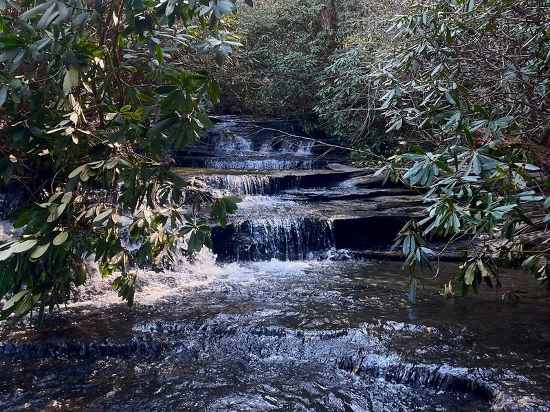
Read the terrain. Two cascades drop into a pool so blue it looks like someone filtered the color in.
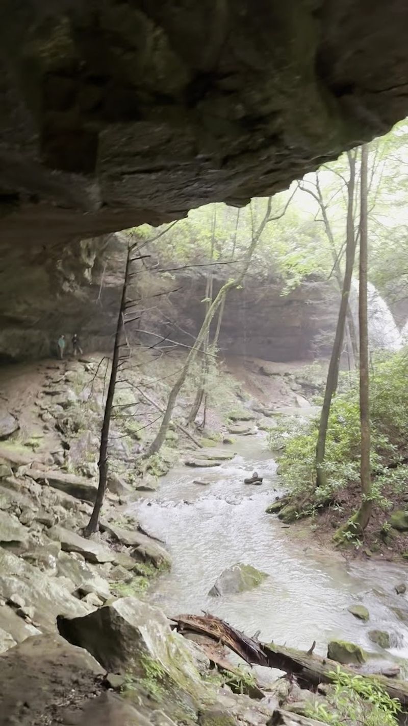
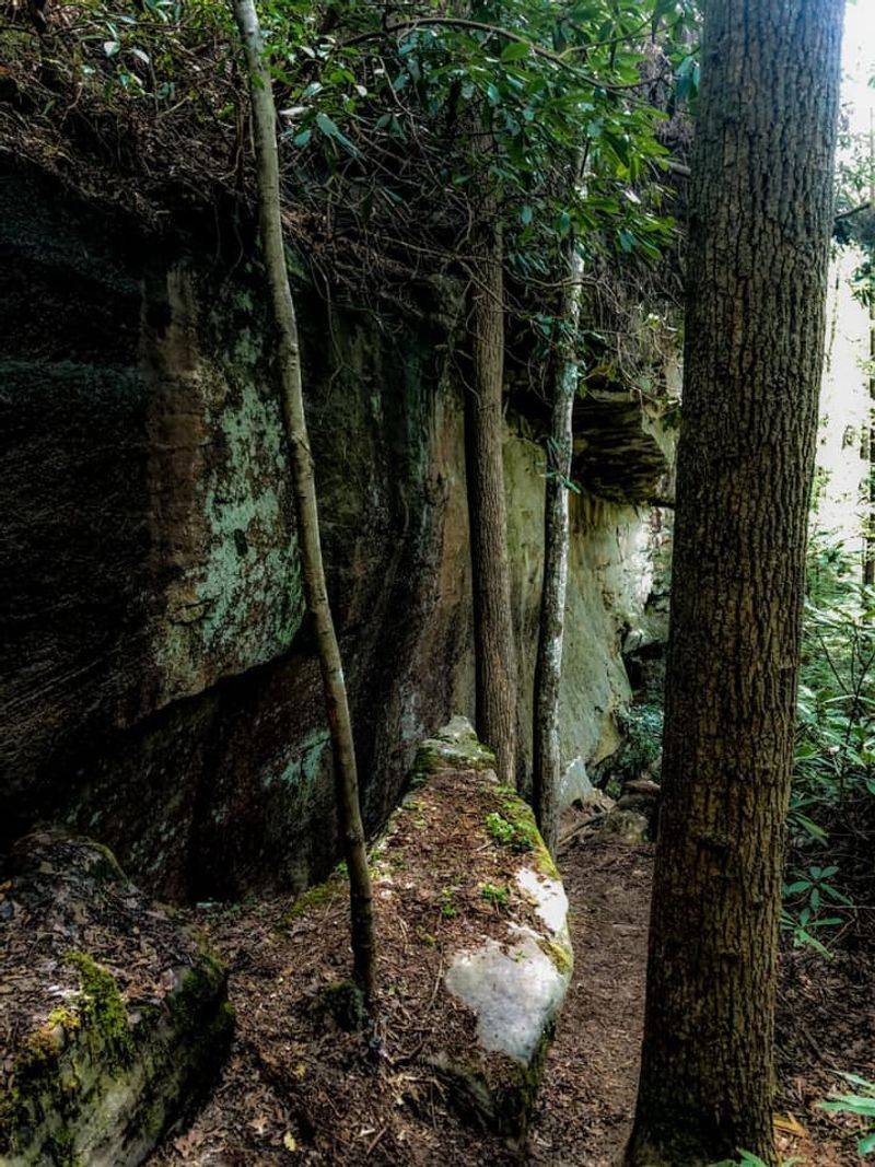
Cliff walls rise on both sides of a narrow sandstone gorge in Kentucky. Ferns drape the rock and the quiet is total.
Reaching it means muddy crossings, slick rock slabs, and a trail that vanishes in the middle stretch. A major tornado caused serious closures across this part of the forest in 2025.
Checking current access conditions before heading out is not optional. For hikers who prepare and commit, the payoff is rare and worth every uncertain step.
The Unsigned Trailhead And How To Find It
No sign. No kiosk.
No trail map bolted to a post. The trailhead for Pine Island Double Falls is famously unmarked, and that is the first real test of whether you want to be there.
The access road turns to gravel well before you reach the starting point, and the final stretch near address marker 4117 can feel more like a private driveway than a public forest road. Parking is extremely limited, with room for only a couple of vehicles at most.
The GPS coordinates 37.0754, -84.2888 are more reliable than standard navigation apps, which have reportedly sent visitors to the wrong location. Apps like AllTrails with a downloaded topographic map have proven more dependable for reaching the correct spot.
A four-wheel drive or high-clearance vehicle is strongly recommended for the gravel road leading in. The road can be rough, narrow, and difficult to share with oncoming traffic.
Arriving early gives you the best shot at parking and a quieter experience on the trail.
Reading The Trail When There Are No Markers
The trail does not hold your hand. That is the honest truth about hiking to Pine Island Double Falls, and experienced hikers tend to love it for exactly that reason.
For most of the route, the creek is your compass. Follow Pine Island Creek and you will stay on the right path.
The trail merges with the creek bed in sections, meaning you may walk through shallow water rather than beside it. Multiple stream crossings are part of the experience, so waterproof footwear is a smart call.
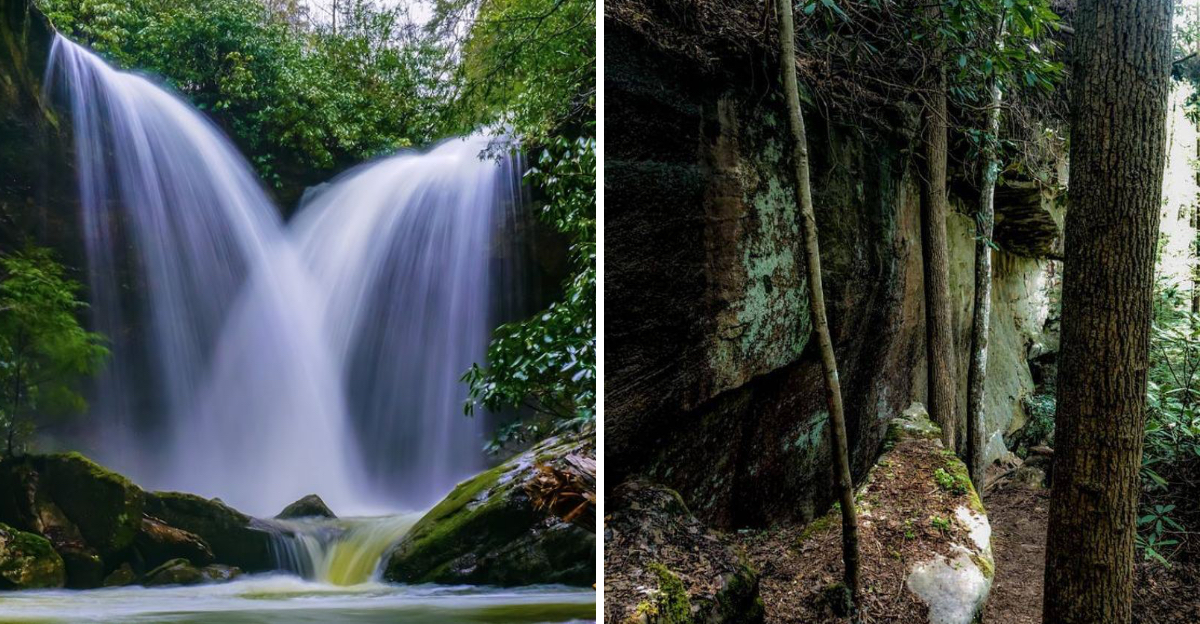
Orange flagging tape tied to trees marks portions of the route, and some creative visitors have used shotgun shells as informal trail blazes. The markers can disappear at critical junctions, particularly where the trail requires a left turn near the upper falls.
When the trail fades entirely, which it does in the middle third of the route, keep the creek close and trust your ears. The sound of the falls grows louder as you approach.
That audio cue is often more reliable than any marker on the path.
What Makes This Waterfall So Special
Two waterfalls. One jaw-dropping pool.
Zero signs pointing the way.
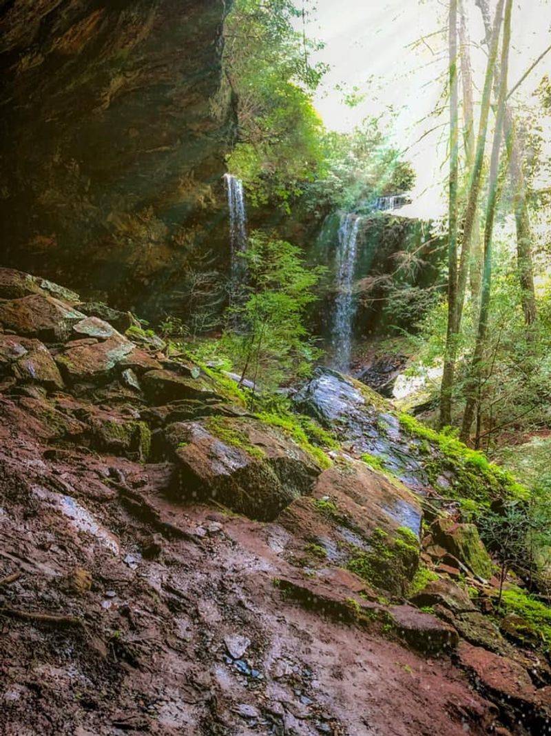
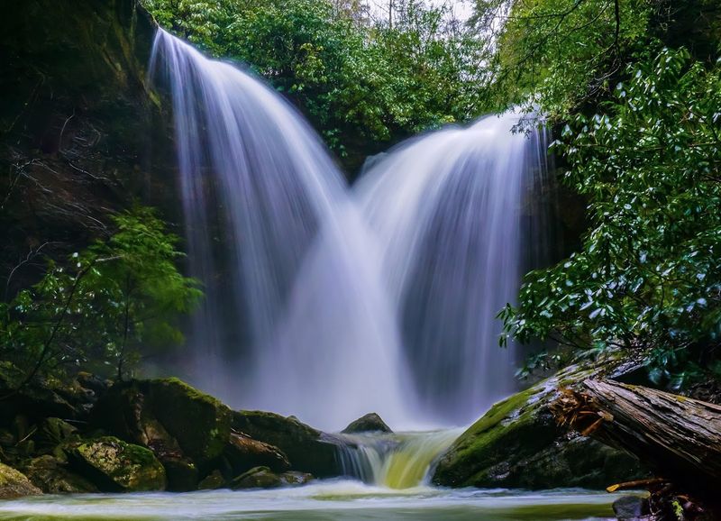
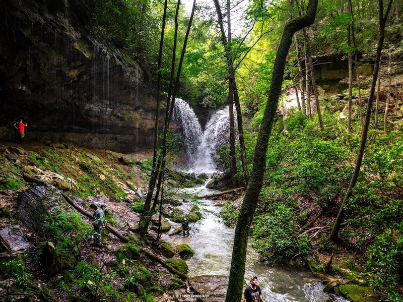
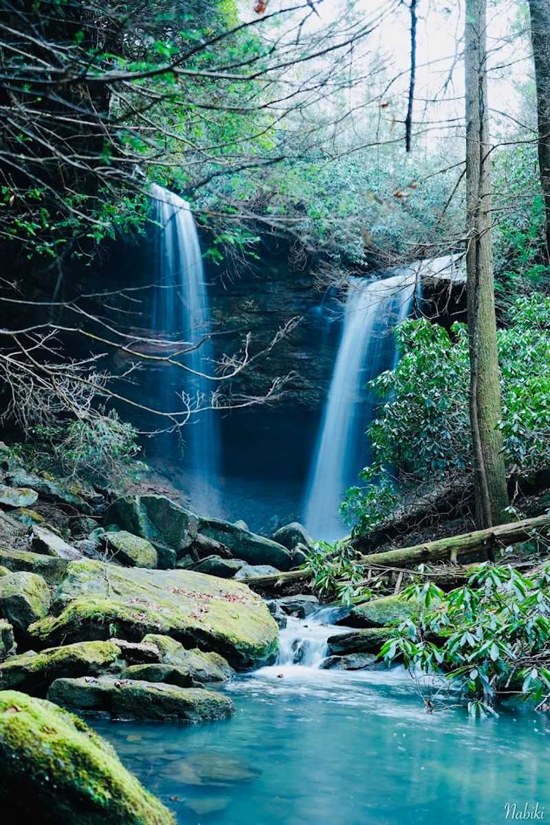
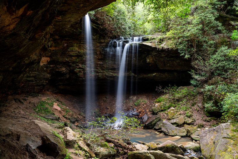
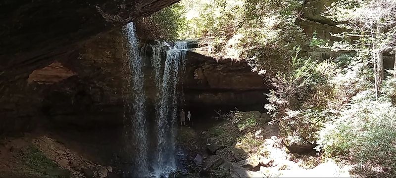
Pine Island Double Falls sits inside the Daniel Boone National Forest in Kentucky, between Somerset and London in Laurel County. The falls consist of two separate cascades, one dropping around 20 feet and the other plunging roughly 41 feet, both feeding into a pool described by visitors as brilliantly blue and almost surreal in color.
That aquamarine water is not a filter trick. The combination of the sandstone gorge walls, the depth of the pool, and the clarity of Pine Island Creek all work together to produce that striking cobalt hue.
What sets this place apart is not just the visual reward. It is the total package: a narrow gorge, towering cliff walls, dense forest canopy, and the sound of crashing water echoing off shale and siltstone formations.
Very few people know about it. Even fewer make the effort to find it.
That contrast alone makes the destination feel genuinely extraordinary.
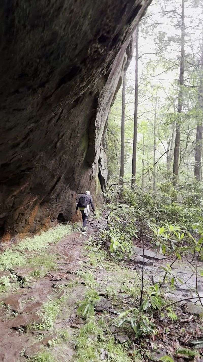
The Terrain That Keeps Casual Visitors Away
Mud, steep climbs, slippery rock, and downed trees: this trail filters out anyone who is not serious about the destination.
The hike is rated as moderately challenging and covers roughly 1.3 to 1.4 miles out and back. That sounds manageable, but the terrain tells a different story.
Steep inclines appear near the upper falls, and some creek crossings involve smooth sandstone slabs that become extremely slick when wet. One particular crossing over a low-angle slab above a muddy pool has been flagged by multiple visitors as the trickiest spot on the route.
Fallen trees across the path add another layer of navigation. The trail is not regularly maintained, so conditions can change dramatically after storms or heavy rain.
Sturdy, ankle-supporting hiking boots are not optional here. Bug spray is equally important during warmer months when the dense forest canopy creates ideal conditions for insects.
Taken slowly and carefully, the trail is manageable for reasonably fit hikers. Rushing it, especially on wet days, is where people run into trouble.
Patience pays off here more than speed ever will.
What Waits At The End Of The Creek
The moment the falls come into view, everything that felt difficult about getting there instantly recedes.
The main cascade drops roughly 41 feet in a powerful, roaring sheet of white water. A secondary falls at around 20 feet adds another layer of sound and motion that makes the whole gorge feel alive.
Both falls feed into that signature aquamarine pool, which sits at the base of steep cliff walls draped in ferns and moss.
A large rocky outcropping to the left of the falls offers a natural platform for photography. The angle from that ledge captures both cascades and the pool in a single frame, which is why many of the most striking images of this spot were taken from exactly that position.
Little fish dart through the shallower sections of the pool below the falls. The gorge amplifies the sound of the water, wrapping visitors in a full sensory experience that no photograph fully captures.
Standing there, it becomes easy to understand why people call this Kentucky’s best-kept secret.
Best Conditions For Visiting The Falls
Timing matters more at this waterfall than at almost any other destination in the region.
The falls are fed by Pine Island Creek, which is seasonal in nature. During dry spells, the cascades can slow to a trickle or even run dry entirely, leaving visitors with a scenic gorge but no waterfall to speak of.
The difference between a disappointing visit and a breathtaking one often comes down to recent rainfall.
The best time to visit is within a day or two after significant rain or after snowmelt in late winter and early spring. Flow is typically strongest from late fall through spring, when precipitation is more consistent across this part of Kentucky.
Summer visits can still be rewarding, but checking recent weather before making the drive is a wise habit.
Visiting after a heavy rain also deepens the color of the pool, making that aquamarine hue even more vivid and photogenic. The trade-off is that wet conditions make the trail slicker and the creek crossings more challenging.
Choosing the right day is a balance worth thinking through carefully before heading out.
Safety Considerations Every Visitor Should Know
This trail does not come with a safety net, and that is worth taking seriously before you go.
Cell service is unreliable or completely absent in the wooded areas surrounding the falls. Downloading offline maps before leaving home is not just a suggestion; it is a practical necessity.
Letting someone know your plans and expected return time is a basic precaution that experienced hikers treat as standard.
The low-lying sections of the trail are prone to flooding after heavy rain. Swift currents in the creek can make crossing dangerous when water levels are elevated.
Swimming in the pool is tempting given how beautiful it looks, but undertows and swift currents have been noted as real hazards, especially after storms.
The trail is not maintained on a regular schedule, so conditions after major weather events can be significantly different from what any online report describes. An EF-4 tornado struck the area on May 16, 2025, causing serious damage to the surrounding national forest lands and resulting in a multi-year area closure that remains in effect.
Checking current trail status before visiting is an important step that should not be skipped.
The Gorge Itself Is Worth The Walk
Even before the falls appear, the landscape earns its keep.
The trail winds through a narrow gorge defined by tall sandstone and shale siltstone walls that rise sharply on both sides. The creek runs alongside and through the path, creating a constant soundtrack that shifts from a gentle trickle to a steady rush depending on recent rainfall.
Dense forest canopy filters the light into soft, shifting patterns on the trail below.
Towering rock formations appear at intervals along the route, some draped in moss and lichen that signal how little human traffic passes through. The vegetation is thick and varied, with ferns, wildflowers, and overhanging tree roots creating a tunnel-like atmosphere in certain sections.
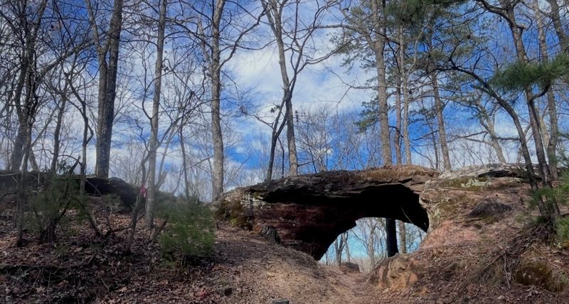
Visitors who have driven to this part of Kentucky have also noted cool stone arch formations visible along the gravel road leading to the trailhead. Those natural arches add an extra layer of interest to the approach before the hike even begins.
The gorge rewards slow walkers who stop to look around rather than just push toward the destination.
How This Place Stays Off The Radar

No ranger station. No entrance fee.
No interpretive panels explaining the geology. Pine Island Double Falls stays hidden because nothing about it invites casual discovery.
The lack of road signage means that drivers passing through this part of Kentucky have no reason to slow down or turn off. The gravel access road looks uninviting to anyone without prior knowledge of what lies at the end.
The trail itself, once found, offers little reassurance to anyone who expects clear markings and groomed paths.
That combination of factors acts as a natural filter. The people who make it to the falls are the ones who did their research, prepared properly, and committed to the effort.
That self-selecting crowd tends to treat the place with more care and leave it quieter than a heavily promoted attraction ever could be.
The result is a destination that has maintained its wild character despite being located within a national forest that sees significant visitor traffic overall. Its obscurity is not an accident.
It is the outcome of a place that has never been packaged for easy consumption, and that is a rare thing worth protecting.
What To Pack For This Particular Hike
Packing smart for this trail makes a real difference between a frustrating outing and a memorable one.
Waterproof hiking boots are the top priority. The creek crossings and muddy sections will soak through trail runners quickly, and wet feet make the steep sections significantly less pleasant.
Trekking poles are worth bringing for the slippery sandstone crossings, particularly the one section that multiple visitors have flagged as the trickiest on the route.
Bug spray is essential during spring and summer. The dense forest and creek environment create prime conditions for insects, and the slower pace of careful navigation means more exposure time.
A fully charged phone with an offline topo map downloaded in advance handles the navigation gap left by unreliable cell service.
Carrying more water than you think you need is always smart on an unmarked trail where the return route may take longer than expected. A small first aid kit rounds out the essentials.
The hike is short in distance but demands more preparation than its mileage suggests.
The Drive In Is Part Of The Adventure
Getting to the trailhead is its own kind of adventure, and not everyone arrives prepared for it.
The paved road gives way to gravel long before the trailhead appears. The gravel road is narrow and can be difficult to navigate when another vehicle is coming from the opposite direction.
Pulling over requires careful judgment, and the road surface can be rough enough to rattle an unprepared vehicle.
A four-wheel drive or high-clearance vehicle is strongly recommended. Standard sedans and low-clearance cars have reportedly struggled on the final stretch, and turning around on a narrow forest road is not a comfortable experience.
Giving yourself extra time for the drive is a practical habit worth building into your plan.
The payoff along the drive includes views of natural stone arch formations that frame the road in unexpected ways. Those arches have caught the attention of hikers who arrived expecting only the waterfall and left with bonus scenery they did not plan for.
The road itself, for all its roughness, sets the mood for everything that follows.
Why The Quiet Here Feels Different
Crowds change a place. Their absence changes it even more.
At Pine Island Double Falls, the quiet is a defining feature. The combination of the unmarked trailhead, the rough access road, the unsigned trail, and the physical demands of the hike means that the number of people who reach the falls on any given day is very small.
That low traffic creates an atmosphere of genuine solitude that is increasingly hard to find in popular outdoor destinations.
Standing beside a 41-foot waterfall with no one else around, hearing only the crash of water and the occasional bird call echoing off sandstone walls, is an experience that feels increasingly rare in Kentucky and beyond. Most waterfall destinations in the region come with crowds, noise, and the constant awareness of other people.
This one does not. The effort required to reach it functions as an invisible velvet rope, keeping the experience intimate and the setting unspoiled.
That quiet is not just pleasant. It is the whole point of coming here, and it is exactly what makes Pine Island Double Falls worth every uncertain step of the journey.