This Massachusetts Waterfall Flows Past Glacial Potholes That Look Almost Otherworldly
Ever seen a riverbed that looks like it was scooped by giants? Massachusetts has a waterfall scene that feels more like a science lesson you actually want to stand beside.
Water rushes over worn rock, then slides past deep circular basins carved by glacial force long before road trips, cameras, and weekend plans existed.
The shapes look too smooth to be accidental. That is what makes the stop so strange and fun.
You are not just looking at falling water. You are staring at stone that kept a record of ice, pressure, and time.
Bring comfortable shoes and a little curiosity, because this is the sort of place that makes people point, pause, and ask how nature managed to pull it off.
It is quick to admire, easy to remember, and weird enough to keep talking about later.
How The Potholes Actually Formed Over 14,000 Years
Long before anyone thought to build a town here, the Deerfield River was already doing something extraordinary.
Around 14,000 years ago, as the last ice age wound down, meltwater surged across the landscape with enormous force, carrying stones and sediment that had nowhere to go but down.
Those stones landed in natural cracks in the riverbed and stayed there.
The fast-moving current spun them in tight circles, round and round, year after year, effectively drilling into the hard rock below.
The process is slow by human standards but relentless by geological ones.
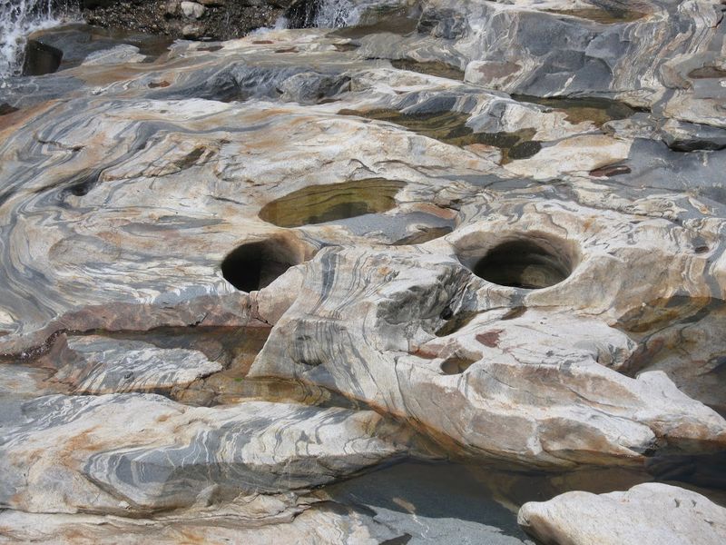
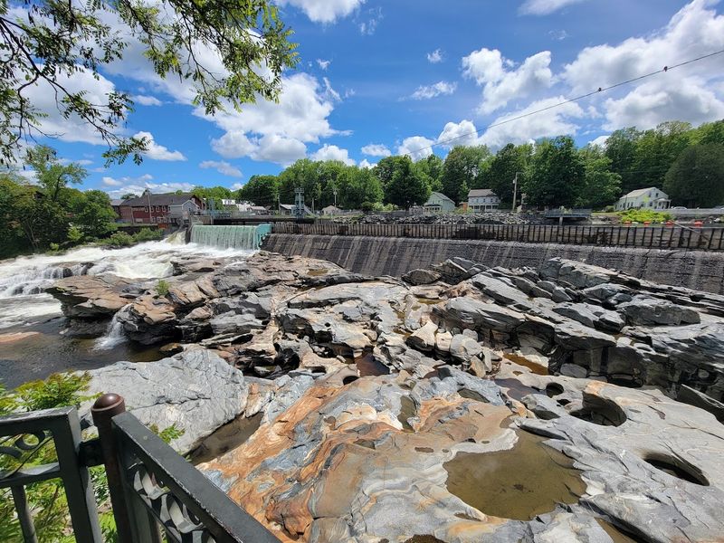
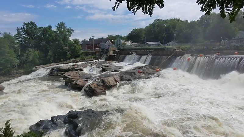
The bedrock here is gneiss, a pressurized form of granite that shows off distinctive light and dark speckles when the water recedes enough to reveal it. That combination of durable rock and persistent motion produced the potholes visitors see today.
Over fifty of them now dot the riverbed at Shelburne Falls, each one a record of time, pressure, and water doing what water does best.
The Staggering Size Range Found In One Riverbed
Not all potholes are created equal, and nowhere is that more obvious than along this stretch of the Deerfield River. The smallest formations measure just six inches across, roughly the size of a cereal bowl pressed into stone.
Stand near one and it looks almost delicate. Then you turn and see the largest.
At 39 feet in diameter, it is technically classified as a plunge pool rather than a standard pothole, formed by the sustained force of falling water at the base of Salmon Falls.
The scale difference between the two extremes is genuinely difficult to process in person.
Over fifty individual formations occupy this one section of riverbed, and no two are identical. Some are perfectly circular.
Others have elongated shapes where multiple smaller potholes merged over centuries.
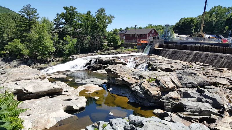
Visiting in late summer, when water levels drop and the bedrock becomes more exposed, gives the clearest sense of just how varied and abundant these formations really are.
Spring floods hide many of them completely beneath fast-moving water, which creates a different kind of spectacle altogether.
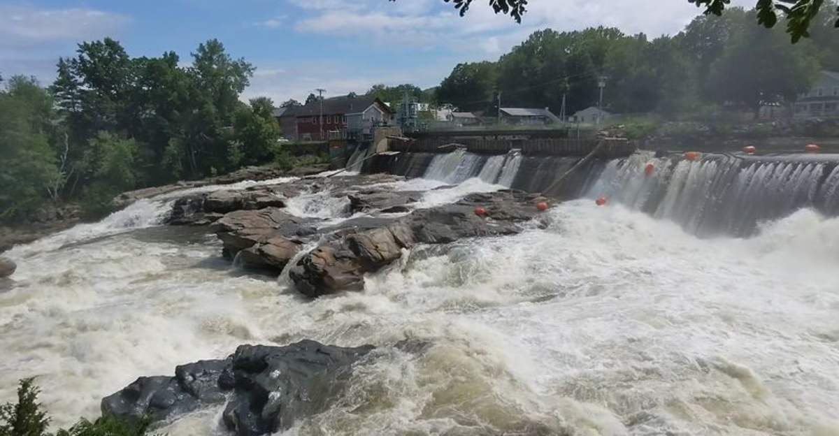
Salmon Falls And The Waterfall That Powers It All
The waterfall at this site goes by the name Salmon Falls, a name earned honestly.
For centuries, Atlantic salmon used this stretch of the Deerfield River as a migration corridor, leaping up the falls on their way to upstream spawning grounds.
The image of fish clearing a waterfall in full view of a small New England town is the kind of detail that sticks with you.
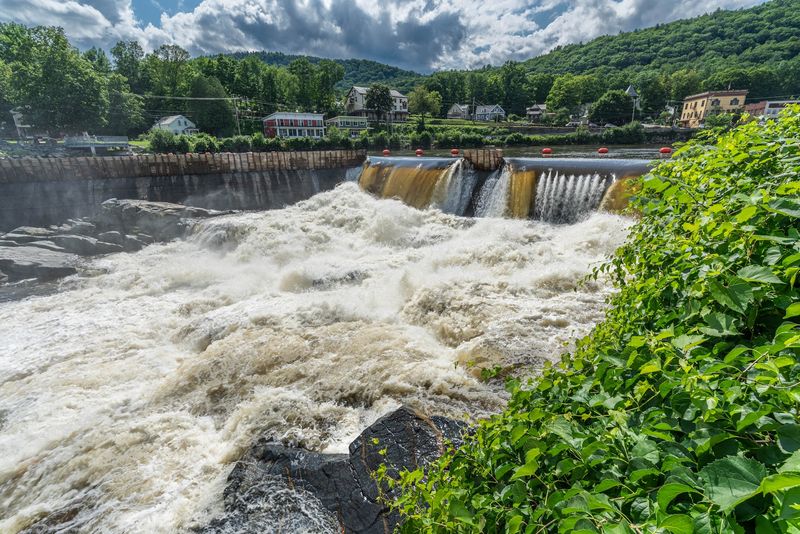
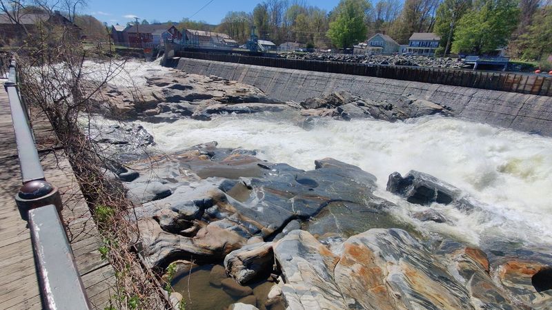
A hydroelectric dam now sits at the top of the falls, and the water that flows over it feeds the dramatic scene visitors observe from the viewing deck below.
When the dam releases water at full capacity, the sound alone is enough to make conversation difficult.
The roar carries down Deerfield Avenue and into the surrounding streets. Spring is widely considered the best time to witness the waterfall in full force.
Snowmelt and seasonal rain push the river to impressive heights, and the water moves with a velocity that makes the pothole formation process easy to imagine.
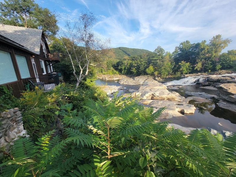
Even at lower summer flows, the falls maintain a steady presence that anchors the entire site and gives it a sense of continuous, living motion.
What The Observation Deck Actually Lets You See
Access to the riverbed itself is no longer permitted, and for good reason.
The rocks are slick, the currents unpredictable, and the terrain uneven in ways that are not immediately obvious from a distance.
Swimming in the pools has been prohibited since 2002, following a series of injuries that made the risks undeniable.
The observation deck at the end of Deerfield Avenue provides a clear, elevated view of the potholes and the falls.
It is well-constructed, safe, and thoughtfully positioned to give visitors a broad perspective of the site without requiring any scrambling or risk.
Benches line the area, and a monument sign explains the geology in plain, readable language.
Parking along the street is straightforward, with parallel spots available very close to the lookout point. The entire stop, from parking to viewing to reading the interpretive signage, takes most visitors between fifteen and thirty minutes.
For anyone passing through western Massachusetts on Route 2, this qualifies as one of the more rewarding short detours the region offers. The site sits at J726+W7, Shelburne Falls, MA 01370, easy to locate and simple to visit.
The Gneiss Bedrock And Its Striking Visual Character
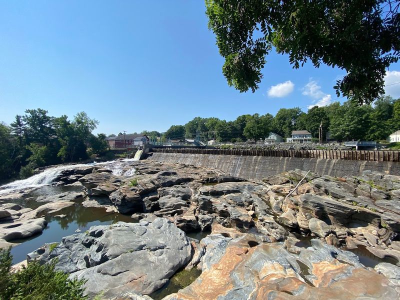
Geology rarely looks this good. The bedrock at Shelburne Falls is gneiss, a metamorphic rock formed under intense heat and pressure deep within the earth.
What makes it visually arresting is its banding, alternating layers of light and dark minerals that run through the stone in flowing, almost rhythmic patterns.
When the rock is wet, which it almost always is near the falls, those mineral bands catch the light in ways that make the surface appear almost polished.
Visitors frequently mention the color of the boulders in the river as one of the more unexpected pleasures of the stop.
It is not what most people anticipate from a riverbed in rural Massachusetts.
The gneiss also explains why the potholes formed with such clean, rounded edges.
This rock type is hard enough to resist shattering but responds to prolonged abrasion by wearing smoothly rather than crumbling.
The stones that drilled these formations left behind shapes that look almost intentional, as if carved by a patient hand rather than millennia of spinning river sediment.
That quality of surface and form is what gives the site its persistent reputation for looking genuinely otherworldly.
Best Seasons To Visit And What Changes Each Time
The site transforms dramatically depending on when you arrive. Spring brings the highest water levels, when snowmelt and rain push the Deerfield River to its most dramatic state.
The potholes disappear entirely beneath fast, aggressive current, but the waterfall becomes a commanding presence that rewards anyone willing to stand at the deck railing in the wind.
Late summer is the season for actually seeing the potholes themselves. Water levels drop, the bedrock emerges, and the full collection of formations becomes visible across the riverbed.
The contrast between the dark wet rock and the smooth carved holes creates a visual effect that photographs well in almost any light.
Autumn adds another layer, with surrounding foliage turning gold and orange at a time when the low-angle afternoon sun hits the stone at particularly flattering angles.
Winter visits are quieter and less predictable, but the site remains accessible and carries a different kind of appeal for those who enjoy a destination without the company of other visitors.
Each season offers a genuinely distinct experience, which is why many locals return multiple times across the year rather than treating it as a single-visit landmark.
Photography Tips For Capturing The Potholes Well
Few natural subjects reward patient composition the way these potholes do.
The rounded forms, the banded rock, and the moving water all interact differently depending on the time of day and the angle of the light.
Early morning visits produce soft, even illumination that suits the texture of the gneiss.
Late afternoon in autumn, when the sun sits lower and the foliage adds warm color, is widely considered the most photogenic window.
From the observation deck, a wide-angle lens captures the full breadth of the site, including the falls in the background and the spread of potholes across the foreground.
A telephoto setting lets you isolate individual formations and highlight the circular geometry of the larger holes.
If the water is moving fast, a slow shutter speed creates a silky blur that contrasts nicely with the sharp, static rock.
Smartphone cameras handle the site well in good light, particularly in late summer when the exposed rock provides strong visual contrast. Overcast days soften harsh shadows and can actually improve detail in the rock texture.
Bringing a polarizing filter, if you shoot with a dedicated camera, reduces glare on the wet stone surfaces and brings out the mineral banding in the gneiss more clearly.
Combining The Potholes With The Famous Bridge Of Flowers
Shelburne Falls is a small town that punches well above its weight in terms of things worth seeing.
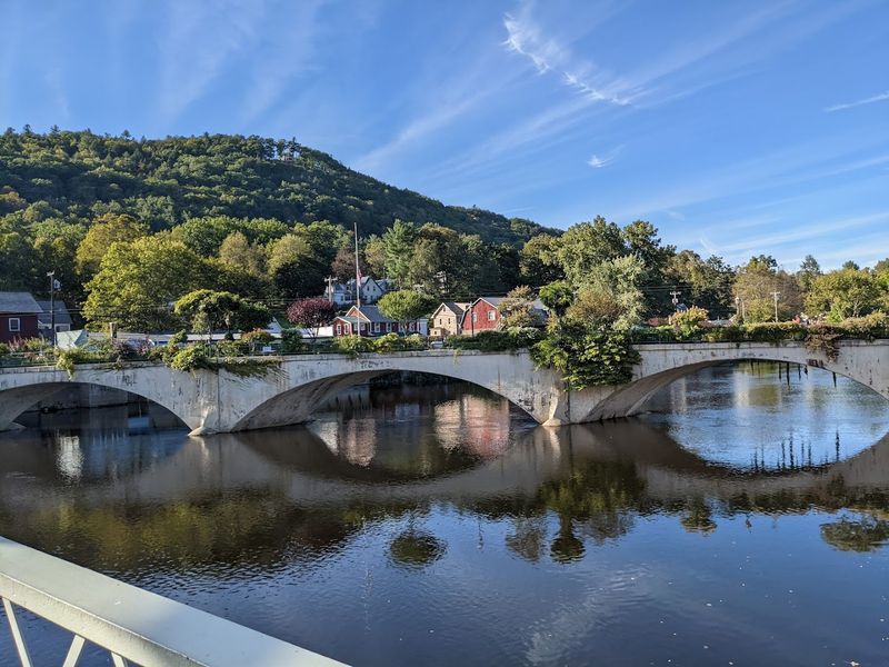
The glacial potholes sit just steps from another attraction that draws visitors from across New England: the Bridge of Flowers.
This former trolley bridge, now covered entirely in planted gardens, crosses the Deerfield River a short walk from the pothole observation deck.
Most visitors combine both stops in a single outing without any difficulty.
The walk between them takes only a few minutes, and the contrast between the two sites is part of what makes the pairing satisfying.
One is raw, geological, and ancient. The other is cultivated, colorful, and maintained with visible care by a local horticultural society.
The town itself has enough character to justify a longer stay.
Quaint shops line the main streets, antique dealers occupy several storefronts, and a handful of well-regarded eateries serve the kind of food that benefits from a relaxed setting.
A bakery on one of the side streets comes up frequently in local conversation as a worthwhile stop.
For anyone making the drive out to western Massachusetts on Route 2, building a half-day around Shelburne Falls is a reasonable and rewarding decision.
Why This Site Continues To Draw Curious Visitors
There is something fundamentally satisfying about a place that requires no interpretation to appreciate.
You look at the potholes and you understand immediately that something significant happened here.
The shapes are too precise, too symmetrical, too numerous to feel accidental, even though they are the product of entirely natural forces operating over an enormous span of time.
Families bring children here specifically because the geology is legible without being simplified. Kids grasp the basic mechanics quickly: spinning stones, hard rock, thousands of years.
From there, the questions tend to get more interesting. Adults, meanwhile, find the site meditative in a way that more manicured attractions rarely are.
The sound of the river, the texture of the stone, and the scale of the formations combine into an experience that lingers.
The site has also appeared in at least one film production, which speaks to its visual distinctiveness. For geocachers, it represents a notable find in the western Massachusetts region.
For casual travelers passing through on Route 2, it is the kind of stop that turns a drive into a memory.
The potholes at Shelburne Falls, MA 01370 are, by any reasonable measure, one of the more genuinely surprising natural features in the entire state.