9 Utah Canyon-Edge Stops You’ll Drive Past Unless You Know

Utah’s best views don’t always come with a big sign and a packed parking lot, sometimes they’re waiting just beyond a bend, where most people keep driving.
In canyon country, the road can feel like a highlight reel, but the real magic happens at the quiet pull-offs and overlooked rims that locals and repeat visitors actually stop for.
Step out, walk a few yards, and the land suddenly drops away into impossible layers of rock, river, and sky.
These are nine canyon-edge stops you’ll miss unless you know exactly when to slow down.
1. Dead Horse Point State Park

Perched 2,000 feet above the Colorado River, this viewpoint delivers one of the most photographed panoramas in all of Utah.
The crimson cliffs drop away dramatically, revealing layers of geological history carved over millions of years.
Legend says cowboys once corralled wild mustangs on this narrow peninsula, and some were left behind to perish—hence the haunting name.
The short walk from the parking area makes this accessible for everyone, yet many travelers zoom past the turnoff without realizing what they’re missing just a few miles off Highway 313.
2. Grand View Point Overlook & Trail
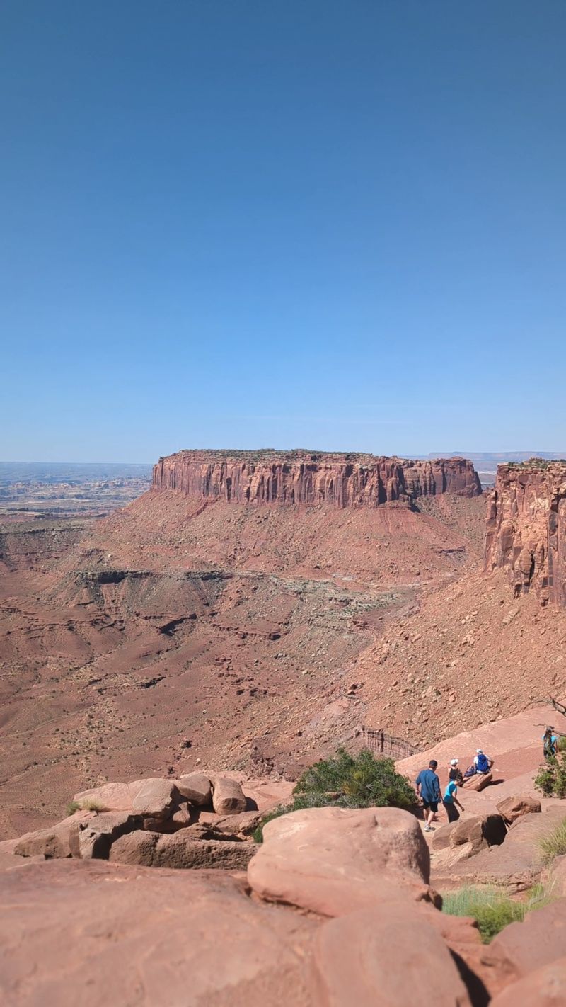
Standing at the southern tip of Island in the Sky, you’ll gaze across a seemingly endless maze of canyons stretching toward the horizon.
This spot offers a mind-bending perspective on just how vast and wild southeastern Utah really is.
The paved trail extends about a mile, perfect for an easy stroll while soaking in views that shift with every step.
On clear days, you can spot the La Sal and Abajo Mountains rising in the distance.
Most visitors stick to Moab’s main attractions, but this overlook rewards those willing to venture deeper into Canyonlands National Park.
3. Shafer Trail Viewpoint
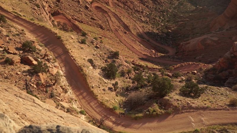
Few sights are as vertigo-inducing as watching the Shafer Trail’s impossibly tight switchbacks zigzag down a sheer cliff face.
Originally carved by ranchers moving cattle, this route now challenges four-wheel-drive enthusiasts seeking adventure.
From the viewpoint, you’ll see vehicles that look like tiny ants crawling along the narrow shelf road hundreds of feet below.
The contrast between the rusty red rock and deep blue sky creates a photographer’s dream.
Pull into the marked viewpoint just past the park entrance, and prepare to have your breath stolen by the sheer audacity of this engineering marvel.
4. Buck Canyon Overlook
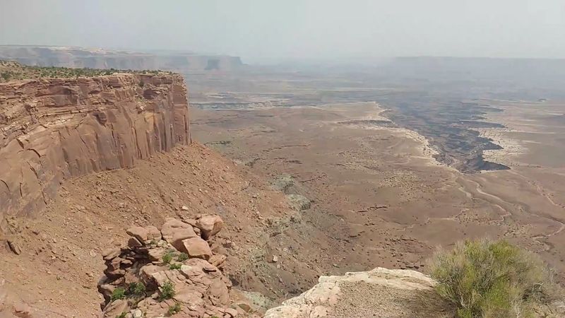
Tucked along the White Rim Road, this overlook remains blissfully unknown to casual tourists who stick to paved routes.
The canyon drops away suddenly, revealing intricate rock formations that seem to shift colors as the sun moves across the sky.
What makes this spot special is the solitude—you might have the entire viewpoint to yourself, even during peak season.
The silence here is profound, broken only by the occasional raven’s call echoing off distant walls.
Reaching it requires either a permit for the White Rim or a commitment to hiking, which keeps the crowds at bay.
5. Orange Cliffs Overlook

Way out in the Maze District, this remote viewpoint offers a glimpse into one of America’s most inaccessible wilderness areas.
The orange-hued cliffs glow like fire during golden hour, creating a surreal landscape that feels more like Mars than Earth.
Getting here requires serious planning—high-clearance four-wheel-drive vehicles, plenty of supplies, and backcountry navigation skills are essential.
But those who make the journey are rewarded with absolute isolation and vistas that few human eyes have witnessed.
This isn’t a casual stop; it’s a destination for adventurers seeking the road less traveled.
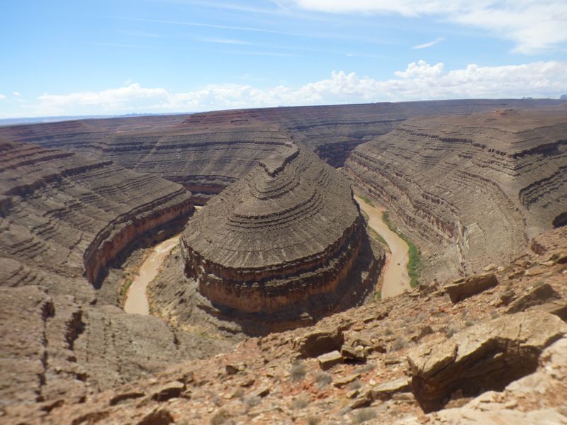
6. Goosenecks State Park
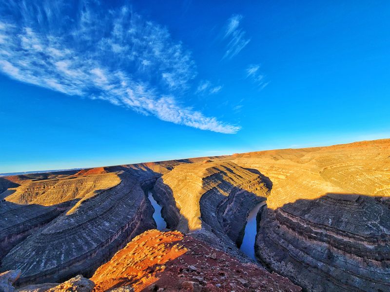
The San Juan River has spent millions of years carving these impossibly tight loops through solid rock, creating one of nature’s most spectacular examples of entrenched meanders.
From 1,000 feet above, the river snakes back on itself in curves so extreme they seem almost impossible.
This tiny state park charges just a few dollars, yet delivers world-class views that photograph beautifully at any time of day.
Sunrise and sunset paint the canyon walls in constantly changing shades of red and gold.
The overlook sits just off Highway 316, easy to miss if you’re not watching for the small signs.
7. Muley Point
Ask experienced Southwest photographers about their secret spot, and Muley Point often comes up in hushed, reverent tones.
From this windswept overlook, you can see Monument Valley’s iconic buttes rising on the horizon, framed by the twisted canyons of the San Juan River below.
The dirt road leading here keeps away tour buses and casual visitors, meaning you’ll likely share this spectacular view with just a handful of fellow adventurers.
Camping is allowed right at the rim, offering front-row seats to one of the finest stargazing locations in the Southwest.
Bring sturdy shoes—the edge is unfenced and dramatic.
8. The Wedge Overlook
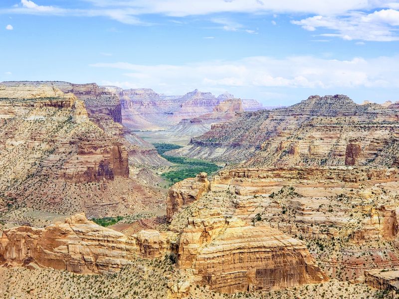
Locals call this the Little Grand Canyon, and once you peer over the edge, you’ll understand why.
The San Rafael River has carved a gorge so deep and dramatic that it rivals its more famous cousin in Arizona—but without the entrance fees or crowds.
A rough dirt road leads to the rim, where you can walk right up to the unguarded edge and look straight down into the abyss.
The geology here tells an ancient story of rivers, uplift, and erosion working together over eons.
Pack a picnic and spend an afternoon watching shadows play across the canyon walls as clouds drift overhead.
9. Strike Valley Overlook
Hidden along the Burr Trail, this overlook provides a stunning preview of Capitol Reef’s famous Waterpocket Fold—a massive wrinkle in the Earth’s crust that stretches for nearly 100 miles.
The striped layers of rock tell a vivid story of ancient seas, deserts, and geological upheaval.
What strikes visitors first is the incredible color palette: reds, whites, purples, and golds all swirled together like an artist’s palette.
The Henry Mountains rise dramatically in the background, adding even more grandeur to an already spectacular scene.
Stop here before tackling the switchbacks that descend into the valley below.