9 Utah Hikes You Should Try This Spring That Reward You With Incredible Views
Blink and you might miss it. One week Utah’s trails are dusted with snow, and the next they burst to life with wildflowers, rushing creeks, and sandstone glowing in the spring sun.
It’s the season when the state’s landscapes feel especially alive, and the hiking opportunities are hard to ignore. Towering arches, narrow slot canyons, and sweeping desert views appear around bend after bend.
Lace up your boots, bring plenty of water, and get ready to explore nine Utah hikes that deliver unforgettable scenery without requiring endless miles.
1. Delicate Arch Trail (Arches National Park, Moab)
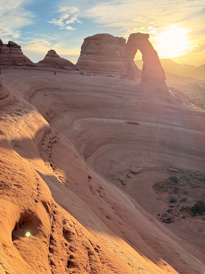
Standing beneath Delicate Arch for the first time feels like stumbling into a postcard you never expected to actually visit. At 1.5 miles one way, this hike climbs about 480 feet through open slickrock terrain that glows burnt orange in the spring sun.
You will not find shade on this trail, so starting early in the morning makes a huge difference on warmer days.
The path begins at Wolfe Ranch, where you can spot ancient petroglyphs carved into the rock by the Ute people hundreds of years ago. From there, the trail winds across open sandstone slabs marked with cairns, giving you sweeping views of the La Sal Mountains dusted with leftover snow.
That contrast of red rock against white peaks is genuinely one of the most beautiful sights in the American Southwest.
Once you round the final ridge and the arch appears, most people stop dead in their tracks. The arch stands 65 feet tall and 45 feet wide, framing the canyon below like a natural window.
Bring at least two liters of water, wear sunscreen, and give yourself time to sit and soak it all in. Utah made this one its state symbol for a very good reason.
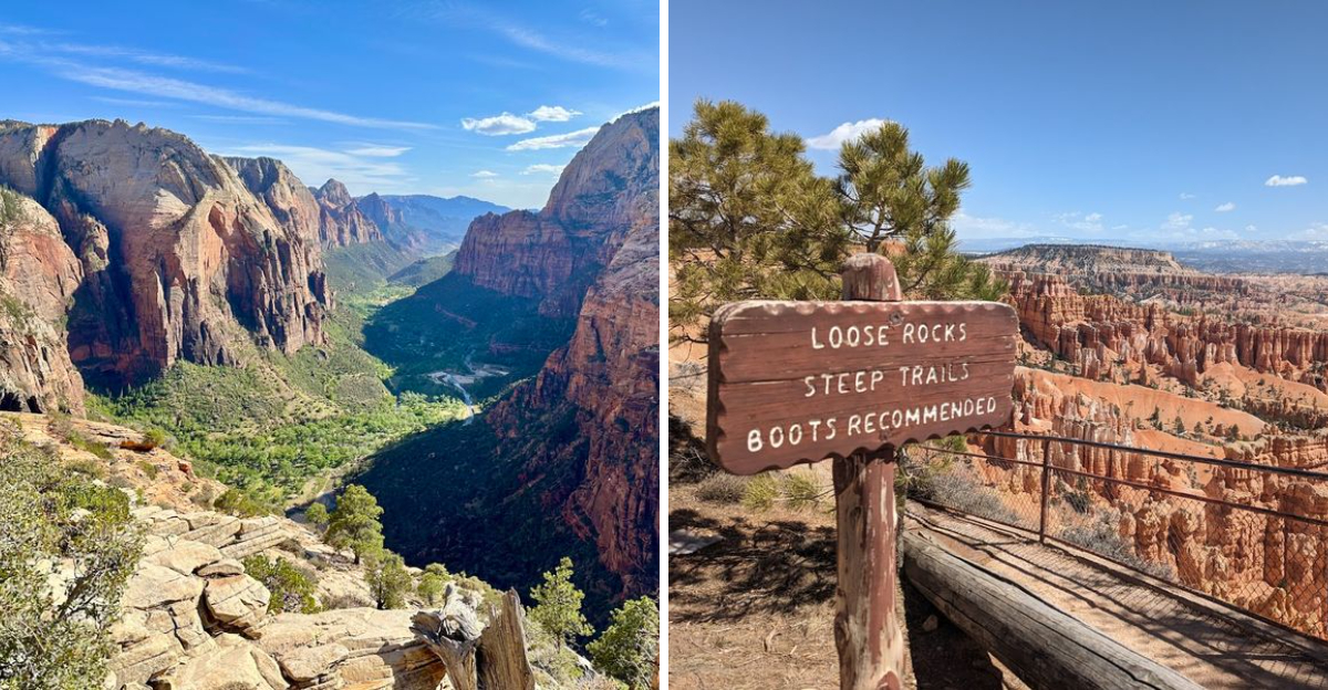
2. Angels Landing Trail (Zion National Park)
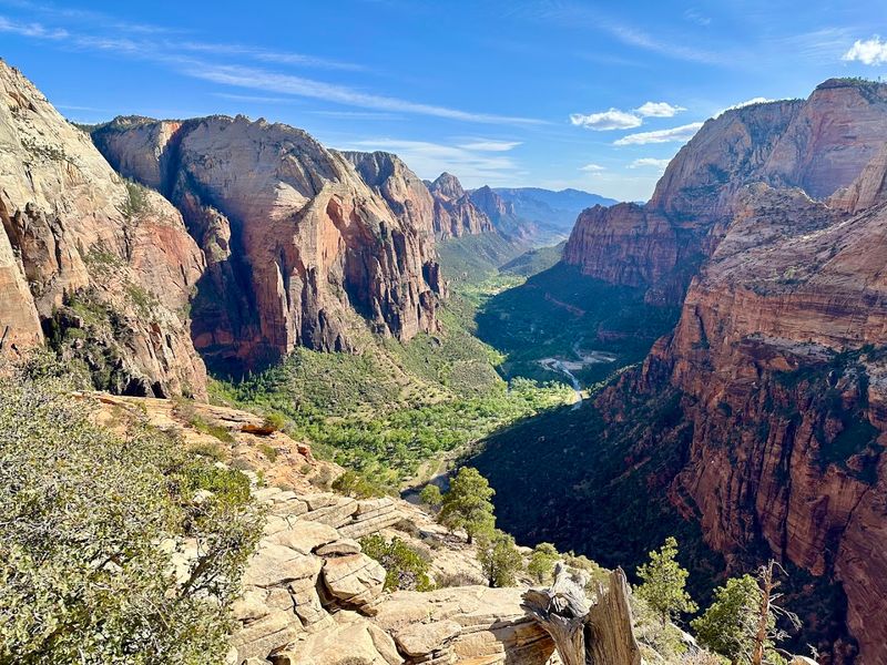
Few hikes in America carry the same electric mix of thrill and beauty that Angels Landing delivers from start to finish. Zion National Park’s most famous trail gains 1,488 feet in just 2.5 miles, pushing you through tight switchbacks, shaded canyon walls, and finally a chain-assisted scramble along a knife-edge ridge with a 1,200-foot drop on both sides.
Starting from the Grotto trailhead, you will pass through Refrigerator Canyon, a cool and narrow section that offers welcome shade before the real climbing begins. Walter’s Wiggles, a series of 21 tight switchbacks carved into the cliff face, leads you to Scout Lookout where many hikers stop to admire the view.
From there, the final half mile requires a permit and a healthy respect for exposure.
Spring is honestly the best time to attempt this hike because temperatures stay manageable and the canyon walls turn a richer shade of red after winter rains. The Virgin River sparkles far below, and the Zion Canyon stretches out in every direction like a living painting.
Permits are required for the final section and can be obtained through a lottery system on recreation.gov. Wear trail shoes with solid grip, bring trekking poles if balance is a concern, and never underestimate how physically demanding this trail truly is.
3. The Narrows (Zion National Park)
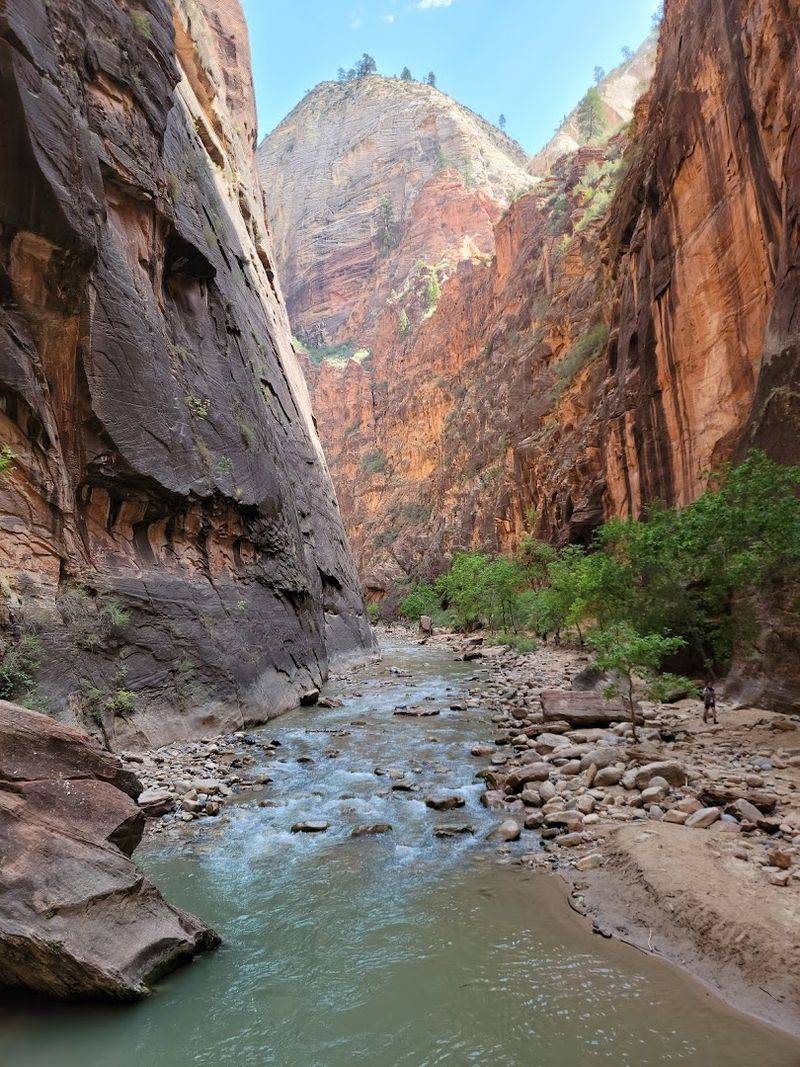
Walking through The Narrows is one of those experiences where you keep pinching yourself because it feels almost too surreal to be real. You are literally hiking inside a river, with walls rising up to 1,000 feet above your head and the cold Virgin River rushing around your ankles.
Spring conditions can mean higher water levels, so always check the park’s current water flow report before heading in.
The most accessible entry point starts at the Temple of Sinawava, where a one-mile paved Riverside Walk leads you to the canyon mouth. From there, the river becomes your trail.
You wade, step over slippery rocks, and push through currents while sandstone walls close in around you in the most magnificent way imaginable.
Renting a dry suit, neoprene socks, and a walking stick from Zion Adventure Company or Zion Outfitter in Springdale is absolutely worth it, especially in early spring when the water runs cold. The canyon changes color as the light shifts throughout the day, going from deep shadow to blazing gold depending on the hour.
Mystery Falls, Orderville Canyon, and Wall Street are popular landmarks along the route. Most day hikers turn around at Wall Street, about 2.5 miles in, and that stretch alone gives you more beauty than you can process in a single trip.
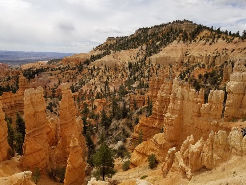
4. Navajo Loop And Queens Garden Trail (Bryce Canyon National Park)
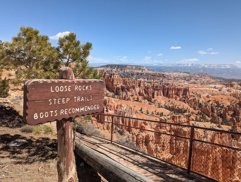
Bryce Canyon looks like someone took a fever dream and turned it into geology. The Navajo Loop and Queens Garden combination trail is the single best way to experience the canyon’s famous hoodoos up close, and it clocks in at about 3 miles with 550 feet of elevation change.
You will earn every single step, and every single step will be worth it.
Most hikers start at Sunset Point and drop down through Wall Street, a narrow slot between towering hoodoo columns that blocks out the sky above you. The trail then flattens through a forest of ponderosa pine before connecting to the Queens Garden section, which winds among some of the most colorful rock formations in the park.
Queen Victoria herself supposedly appears in one of the hoodoos, and once someone points her out, you cannot unsee her.
Spring brings patches of snow to the upper rim while the canyon floor stays dry and hikeable, creating a wild visual contrast that photographers absolutely love. The trail exits at Sunrise Point, so plan for a short walk back along the rim or ask a friend to meet you there.
Bryce Canyon sits at 8,000 to 9,000 feet elevation, so altitude can sneak up on you if you are coming from sea level. Layers are your best friend up here, even on a sunny April afternoon.
5. Canyon Overlook Trail (Zion National Park)
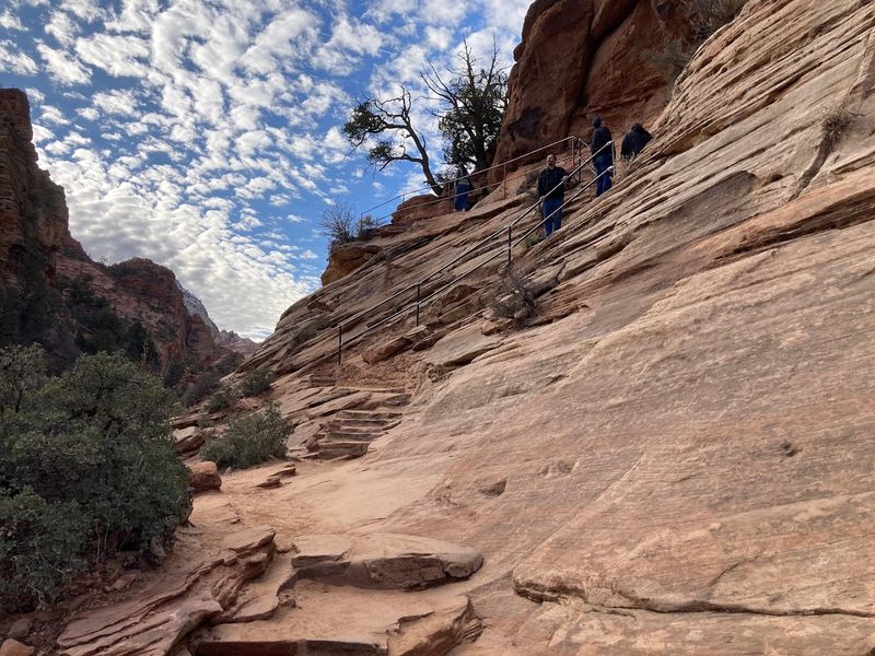
Not every incredible view in Zion requires a full-day commitment or a permit lottery. Canyon Overlook Trail proves that point beautifully in just one mile round trip, rewarding hikers with a sweeping panorama of Zion Canyon that makes you feel like you climbed something far more serious.
It is one of the most underrated short hikes in the entire national park system.
The trailhead sits just east of the famous Zion-Mount Carmel Tunnel, and the path immediately starts weaving through pockets of pine and over slickrock ledges with modest drop-offs. A few sections have handrails bolted into the rock, which adds just enough security to keep things comfortable without removing the sense of adventure.
The whole thing takes about 45 minutes to an hour at a relaxed pace.
At the overlook, you get a bird’s-eye view of Pine Creek Canyon and the Great Arch of Zion, a massive alcove carved into the cliff face that measures 580 feet wide. On a clear spring morning, the canyon walls shift between shades of cream, orange, and deep burgundy depending on where the sunlight hits.
This trail is genuinely accessible for most fitness levels, making it a fantastic option for families or anyone easing back into hiking after winter. Arrive before 9 a.m. to grab parking and beat the crowds that build up fast near the tunnel.
6. Golden Throne Trail (Capitol Reef National Park)
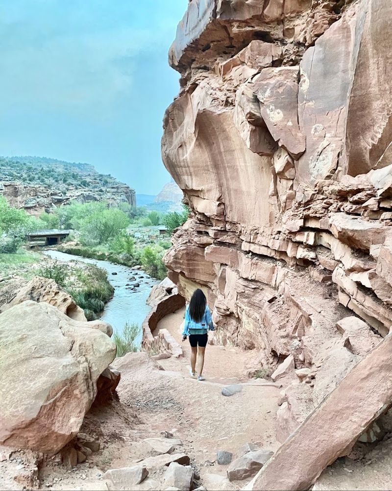
Capitol Reef is the national park that somehow keeps getting overlooked despite being extraordinary, and Golden Throne Trail is the hike that will make you wonder why you waited so long to visit. The trail covers 4 miles round trip with about 740 feet of elevation gain, leading you through Capitol Gorge before climbing up to a ridgeline with front-row views of the massive golden sandstone dome that gives the hike its name.
The Golden Throne formation stands roughly 1,000 feet above the canyon floor and glows with a warm amber color that intensifies in the late afternoon. Spring light hits it at the perfect angle, turning the stone into something that looks almost molten.
Along the way, you pass through layers of the Waterpocket Fold, a 100-mile long wrinkle in the Earth’s crust that Capitol Reef was literally built around.
Wildlife sightings are common on this trail, from mule deer grazing near the trailhead to ravens riding thermals above the canyon rim. The path starts at the Capitol Gorge parking area, which is accessible by car via a dirt road that most vehicles can handle without trouble.
Bring a trail map because signage can be sparse in spots. Capitol Reef gets far fewer visitors than Zion or Bryce, which means you might actually have this stunning viewpoint entirely to yourself on a weekday morning in April.
7. Willis Creek Slot Canyon (Grand Staircase-Escalante National Monument)
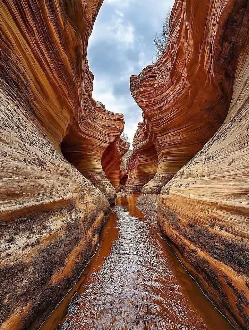
Slot canyons have a way of making you feel both tiny and completely alive at the same time, and Willis Creek is one of the most accessible examples of that magic in all of Utah. Located in the Grand Staircase-Escalante National Monument, this canyon trail stretches about 4.5 miles one way with almost zero elevation gain, making it one of the most relaxed yet visually stunning hikes in the state.
The canyon walls squeeze down to just a few feet wide in places, with smooth sandstone curves that change color from pale cream to deep rust depending on the light. A shallow creek runs along the canyon floor through much of spring, so waterproof boots or trail sandals will keep your feet happy.
Flash flood danger is real here, so check the weather forecast for the entire region, not just the immediate area, before setting out.
Getting to the trailhead requires about 6 miles of dirt road off Skutumpah Road, which can become impassable when wet. A high-clearance vehicle is recommended, and checking road conditions with the Kanab BLM office before driving out is a smart move.
The reward for all that planning is a canyon that feels completely wild and untouched, with cottonwood trees budding green along the creek in spring and red walls rising 30 to 100 feet overhead. Bring a picnic and make a morning of it.
8. Fairyland Loop Trail (Bryce Canyon National Park)
If the Navajo Loop feels like Bryce Canyon’s greatest hits, then Fairyland Loop is the deep cut that serious fans swear by. At 8 miles with about 1,700 feet of elevation change, this trail is the longest and most demanding hike in the park, but it rewards that effort with stretches of solitude and scenery that the shorter trails simply cannot match.
Most visitors skip it entirely, which means you often have the hoodoos to yourself.
The loop begins at Fairyland Point, the northernmost overlook in the park and one of the quieter parking areas. From there, the trail drops into the canyon and winds through dense clusters of hoodoos, past the famous Tower Bridge formation, and through stands of ponderosa pine that smell incredible on a warm spring morning.
The Tower Bridge section alone, about 2 miles in, is worth stopping for a long while.
Spring snow on the upper rim often contrasts beautifully with the rust and pink hoodoos below, giving photographers endless material to work with. Plan for 4 to 6 hours on the trail and pack a full lunch because there are no services once you drop into the canyon.
Trekking poles are a genuine help on the steep descents, especially if morning frost has made the clay soil slippery. Fairyland Loop is the kind of hike that earns a permanent spot in your memory the moment you finish it.
9. Corona Arch Trail (Near Moab, Utah)
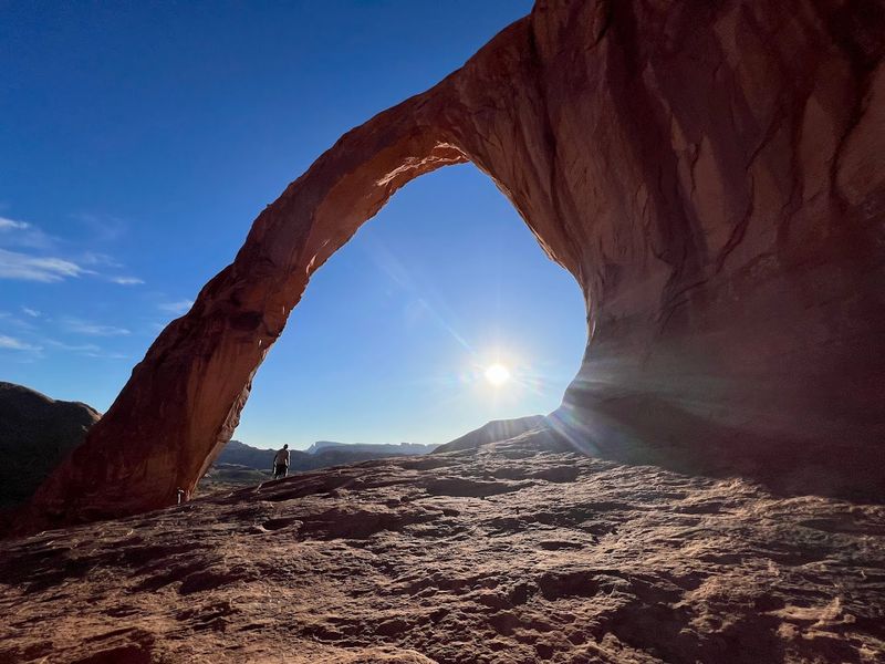
Corona Arch might be the most impressive arch in Utah that most people have never heard of, and that relative obscurity makes visiting it feel like discovering a secret. Located just 10 miles west of Moab off Highway 279, this 3-mile round trip trail gains about 400 feet and leads you to an arch so large that a full-size Boeing 737 could fly through it without clipping the sides.
That is not an exaggeration.
The trail follows an old railroad grade along the Colorado River before climbing through open desert terrain marked with cairns. Two short sections require the use of fixed cables bolted into the rock, which adds a fun scrambling element without making things genuinely dangerous for most hikers.
Kids tend to absolutely love those sections, and honestly, so do most adults.
Spring is a spectacular time to visit because the desert blooms with yellow rabbitbrush and purple phlox, and the morning light turns the Wingate sandstone walls a deep, glowing red. Corona Arch stands 140 feet tall and 105 feet wide, and standing directly beneath it gives you a sense of scale that photos simply cannot capture.
Nearby Bowtie Arch is visible from the same viewpoint, making the stop feel even more rewarding. Parking fills up quickly on weekends, so arriving before 8 a.m. on a Saturday will save you a frustrating wait at the trailhead.