This Wisconsin State Park Lake Offers Some Of The Most Beautiful Views In The State
Some places make you stop mid-step and just stare, and this Wisconsin favourite does exactly that. Huge quartzite bluffs rise above a sparkling lake, creating the kind of scenery that feels almost too dramatic for the Midwest.
One minute, you can be relaxing near the water with a picnic, and the next, you can be climbing toward cliff-top views that make every bit of effort feel worth it. The 360-acre lake adds a calm, glossy centrepiece, while the rugged trails bring plenty of adventure for hikers who like a little challenge.
Add in fresh air, bold rock formations, and photo-ready overlooks, and you have a Wisconsin escape that feels exciting before you even finish parking.
The Bluff Views Are The Park’s Biggest Showstopper
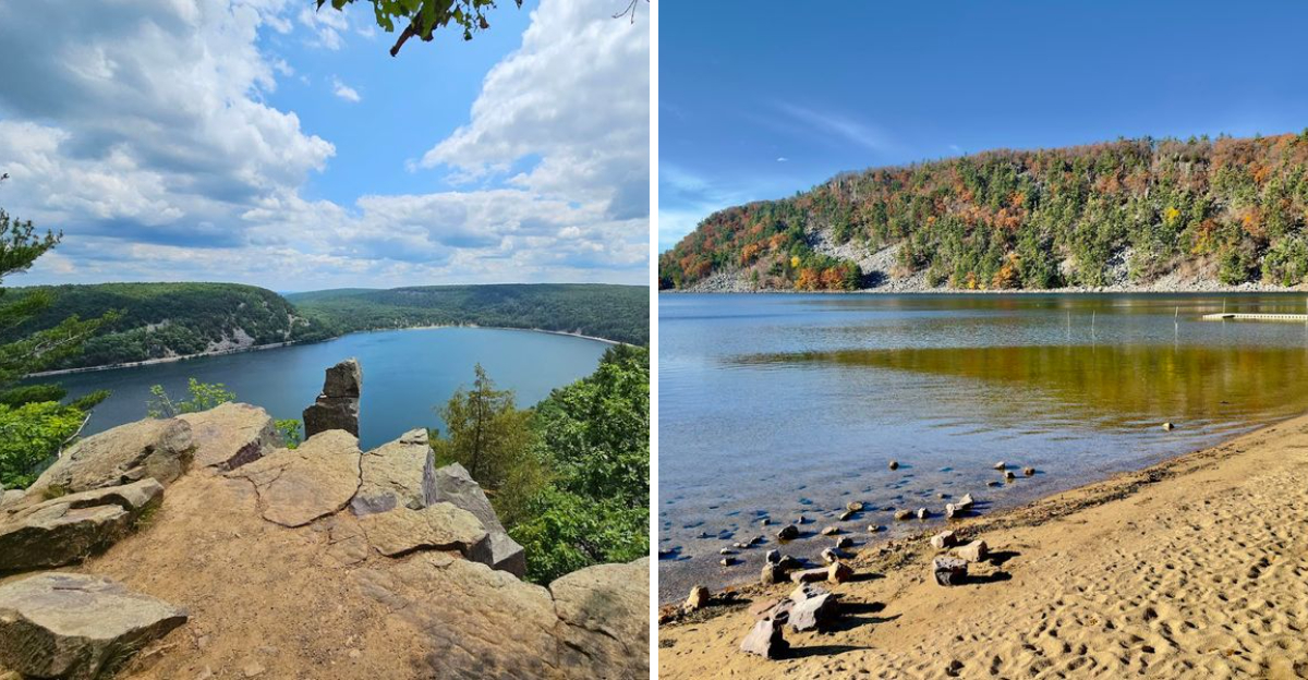
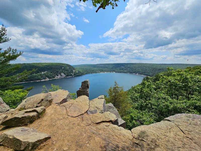
Reaching the top of either bluff rewards visitors with panoramic views that extend far beyond the park boundaries. The lake appears as a brilliant blue ribbon below, framed by forests that shift color with the seasons.
On clear days, the horizon stretches across miles of Wisconsin farmland and woodland, offering a perspective that feels both intimate and grand.
These elevated viewpoints attract photographers during sunrise and sunset when the light transforms the landscape into layers of shadow and color. The overlooks feature natural rock platforms where small groups can gather safely, though the edges remain unguarded and require caution.
Wind often sweeps across these exposed points, carrying the scent of pine and the distant sounds of activity from the lake far below, creating a sensory experience that lingers long after the visit ends.
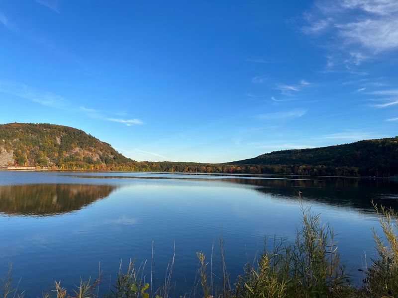
The Lake Covers 360 Scenic Acres
The lake itself stretches across 360 acres of glacially carved landscape, creating a body of water large enough to feel expansive but contained enough to take in from various vantage points. Its origins trace back to the last Ice Age, when massive glaciers sculpted the terrain and left behind this remarkable basin.
The water stays clear throughout most of the year, reflecting the surrounding bluffs and changing skies above.
Visitors can walk nearly the entire perimeter of the lake using interconnected trails that hug the shoreline. The size allows for multiple activities at once without feeling crowded, from swimmers near the beaches to paddlers exploring quieter coves.
On calm days, the surface turns glassy and mirror-like, doubling the visual impact of the towering rock formations that frame it on both sides.
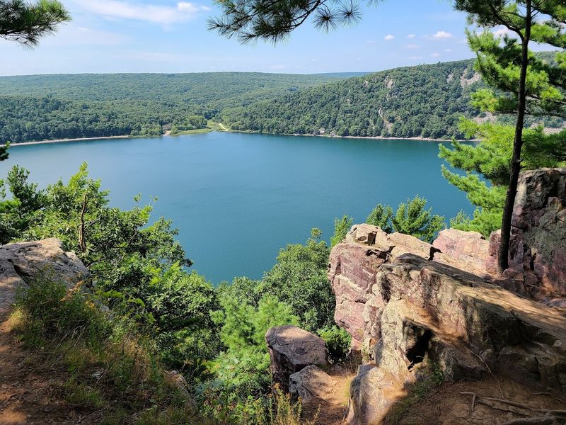
The Water Sits Below 500-Foot Quartzite Bluffs
Ancient quartzite bluffs rise nearly 500 feet above the lake surface, creating some of the most dramatic vertical relief in Wisconsin. These rock walls formed over a billion years ago from sand deposits that were compressed, heated, and eventually thrust upward through geological forces.
The bluffs display bands of color ranging from pale gray to deep purple, depending on mineral content and how light strikes the stone.
Standing at lake level and looking up at these formations produces a sense of scale that photographs rarely capture fully. The bluffs create natural amphitheaters of stone that amplify sounds and channel winds in unexpected ways.
Rock climbers often test their skills on these faces, while hikers prefer the trails that wind along the top edges, offering entirely different perspectives of the same imposing structures.
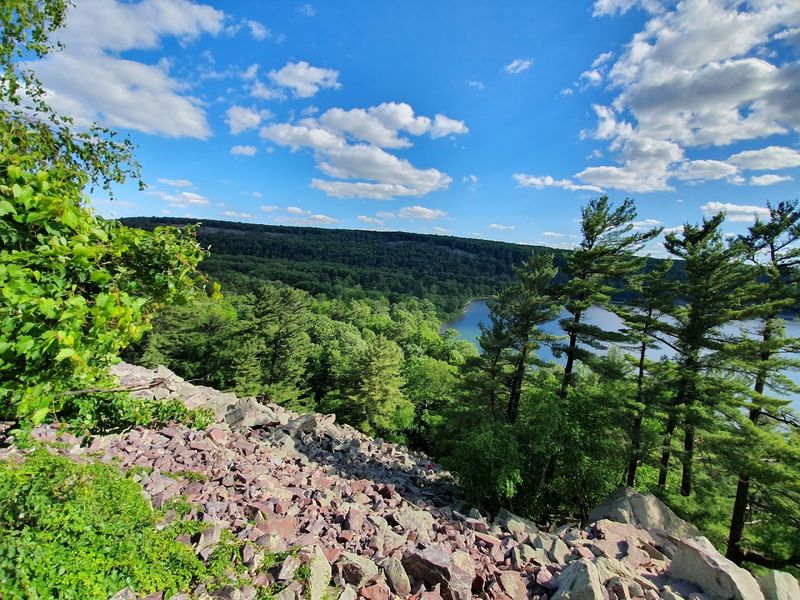
Nearly 30 Miles Of Trails Lead To Different Lake Views
The park maintains close to 30 miles of marked trails that range from flat, accessible paths to steep, rocky scrambles requiring both hands and feet. Each trail offers distinct perspectives of the lake, with some passing through dense forest before suddenly opening onto clifftop vistas.
The variety means visitors can choose routes based on fitness level, available time, and desired scenery.
Trail junctions appear frequently, allowing hikers to customize their loops or cut routes short as needed. Signage throughout the system helps with navigation, though carrying a trail map remains advisable given the network’s complexity.
Some paths follow the shoreline closely, bringing you within steps of the water, while others climb steadily upward through oak and hickory stands before emerging onto exposed rock ledges where the entire lake spreads out below in a single sweeping view.
The Ice Age National Scenic Trail Runs Through The Park
A segment of the Ice Age National Scenic Trail passes directly through Devil’s Lake State Park, connecting this site to a much larger network that traces the edge of ancient glaciation across Wisconsin. This long-distance footpath covers more than 1,000 miles statewide, but the section here ranks among the most scenic and geologically significant.
Hikers tackling the entire trail often cite this portion as a highlight worth lingering over rather than rushing through.
The trail winds along both the East and West Bluffs, incorporating some of the park’s most challenging terrain and rewarding viewpoints. Yellow blazes mark the route, distinguishing it from other park trails that intersect along the way.
Walking this path connects you to a broader story of landscape formation, where glacial activity shaped not just this lake but the entire regional topography visible from the high points.
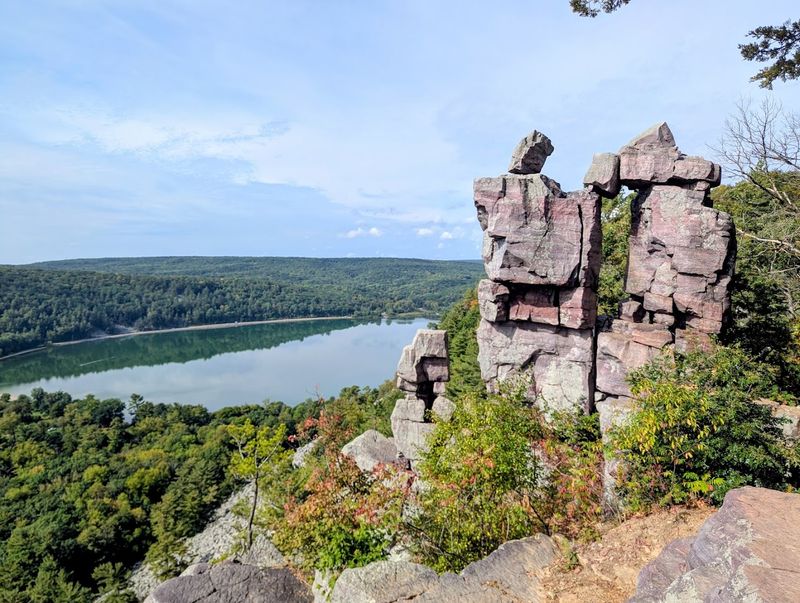
East Bluff Trail Offers Some Of The Most Famous Overlooks
East Bluff Trail delivers some of the park’s most photographed viewpoints, including Balanced Rock and Devil’s Doorway, both natural rock formations that have become symbols of the park. The trail climbs steeply from the lakeshore through a series of stone steps and rocky sections that demand attention and proper footwear.
Once on top, the path follows the bluff edge, providing repeated opportunities to stop and take in the scenery from slightly different angles.
The east side catches morning light particularly well, illuminating the lake and western bluffs in warm tones that contrast with cooler shadows in the valleys. Crowds tend to gather at the named overlooks, but walking a bit farther along the trail often reveals equally impressive viewpoints with more solitude.
The combination of geological curiosities and sweeping vistas makes this route a priority for first-time visitors to Devil’s Lake.
West Bluff Trail Adds Another Dramatic Viewpoint
West Bluff Trail provides a counterpoint to its eastern counterpart, with views looking back across the lake toward the East Bluff and beyond. The climb here proves equally challenging, with steep sections that wind through boulder fields and past rock outcroppings.
Once at the top, the trail opens onto several overlooks where the entire lake spreads out below, framed by the opposing bluff line.
Afternoon light works particularly well on this side, casting long shadows across the water and highlighting the texture of the rock faces across the way. The trail sees slightly fewer visitors than the East Bluff route, offering a bit more breathing room during peak times.
Some hikers prefer to complete a loop that includes both bluffs, descending one side and ascending the other, though this requires stamina and several hours to accomplish comfortably while allowing time to appreciate the scenery.
Sandy Swimming Beaches Make The Lake More Than A Pretty View
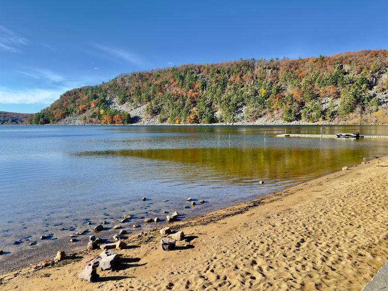
Two main swimming beaches, one on the north shore and another on the south, provide access to the lake for those who prefer getting in the water to simply admiring it from above. Both beaches feature genuine sand rather than rocky shoreline, making them comfortable for spreading out towels and wading gradually into the lake.
The water remains cool even in summer due to the lake’s depth and spring-fed nature, though it warms enough by July to attract plenty of swimmers.
Lifeguards staff the beaches during peak season, and concession stands nearby sell snacks and rent equipment. The north beach tends to be slightly less crowded and offers a more direct view of the bluffs.
Families with young children appreciate the gentle entry and designated swimming areas, while the backdrop of towering rock walls creates a swimming experience quite unlike typical lakefront settings.
Paddling Gives Visitors A Different Look At The Bluffs
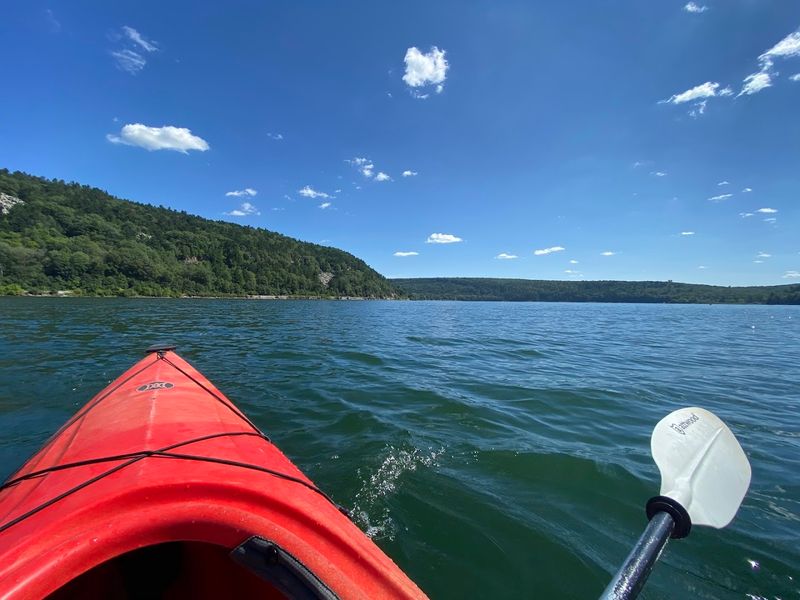
Kayaks and canoes offer an entirely different way to experience the park, bringing you eye-level with the water and allowing close-up views of the bluff bases that remain hidden from shore. Rentals are available at the park, making it easy to get on the water without hauling your own equipment.
Paddling along the shoreline reveals small coves, rock formations, and angles of the cliffs that hikers never see.
The lake prohibits motorized boats, keeping the water calm and quiet for paddlers. On still mornings, the surface often turns glassy, creating perfect reflections of the surrounding bluffs and sky.
Circumnavigating the entire lake takes a few hours at a relaxed pace, with plenty of spots to pause and drift while taking in the scenery. The perspective from water level emphasizes the height of the surrounding rock walls, making them seem even more imposing than they appear from the beaches.
Lakeshore Picnic Areas Make It Easy To Slow Down
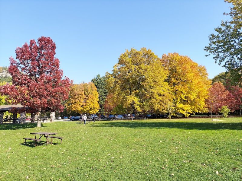
Multiple picnic areas dot the shoreline at S5975 Park Rd in Baraboo, offering tables, grills, and shade trees within steps of the water. These spots provide a base for visitors who want to spend a full day at the park without constantly hiking or swimming.
Families often claim a table early and use it as a hub between various activities, returning periodically for snacks or rest.
The picnic areas closest to the beaches see the most traffic, but walking a short distance along the shore usually reveals quieter spots with equally good views. Many tables sit close enough to the water that you can hear small waves lapping against the shore while eating.
The combination of natural beauty and practical amenities makes these areas ideal for groups who want to enjoy the park at a slower pace, soaking in the scenery without feeling pressured to constantly move from one viewpoint to the next.