Wisconsin’s Most Underrated State Park Is Hiding Some Of The Most Breathtaking Trails In The Midwest
Ever hike somewhere that makes you stop mid-step and forget what you were about to say? Wisconsin has a park that does exactly that.
High above the meeting place of two mighty rivers, the trails climb, curve, and tease you with views that feel almost too big for a weekend walk.
One trail pulls you under leafy cover. Another carries you along the bluff, with the rivers glittering way down below. Around the next bend, you might find a cave, spot a soaring eagle, or stumble across traces of people who stood here centuries ago.
Every mile seems to reveal a different side of the landscape. Best of all, you can enjoy all this without fighting the crowds that flock to Wisconsin’s better-known outdoor destinations.
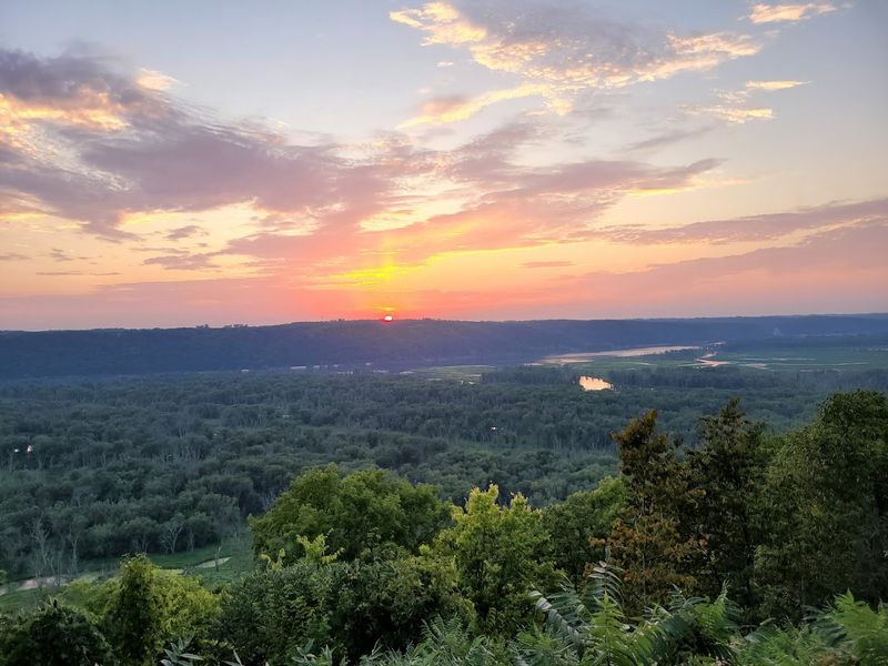
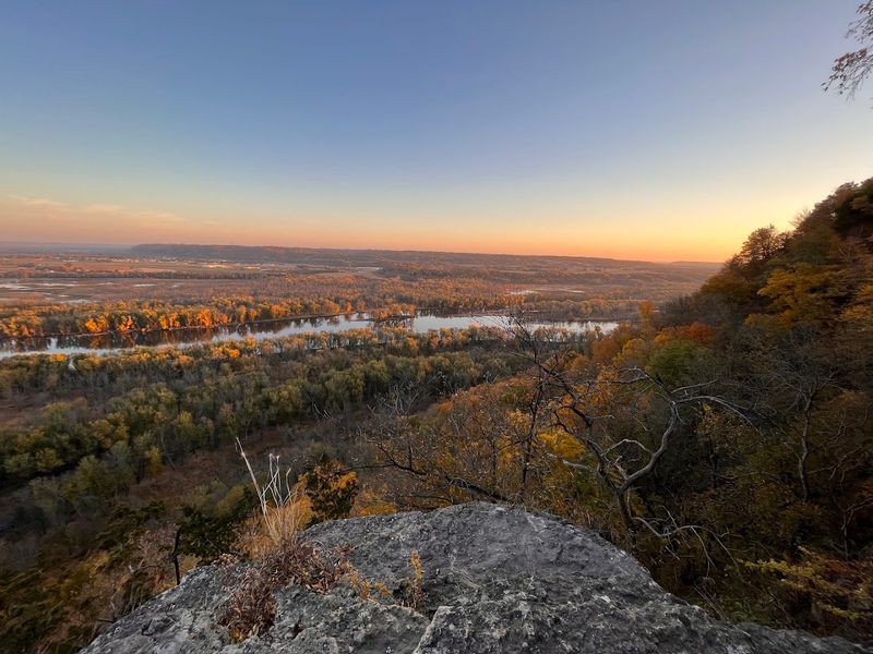
The Blufftop Views Rise 500 Feet Above Two Rivers
Standing at the edge of these bluffs delivers a perspective that makes most people stop mid-sentence. The drop measures 500 feet straight down to the water, with nothing but air and birds between you and the rivers below.
Park designers built overlooks at strategic points so visitors can safely take in views that stretch for miles across three states.
The height creates wind patterns that keep the air moving even on still summer days. Eagles use these updrafts to circle lazily below eye level, an unusual sight that reminds you just how high you are standing.
On clear mornings, the light hits the water at angles that turn the rivers into ribbons of silver threading through green valleys.
Photographers arrive before dawn to capture fog filling the lowlands while the bluffs remain bathed in early sun. The elevation difference creates its own weather patterns, meaning conditions at the top can differ dramatically from what hikers experience down near the water.
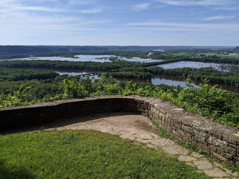
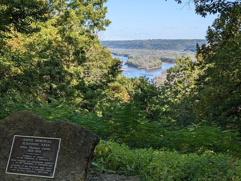
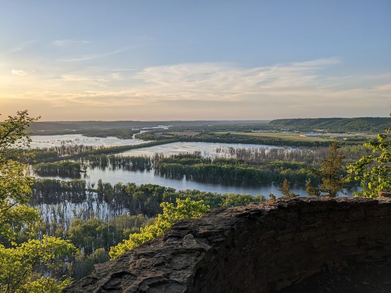
The Wisconsin And Mississippi Rivers Meet Below The Trails
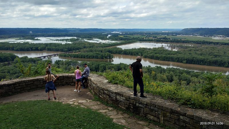
Geography students learn about river confluences in textbooks, but seeing one from 500 feet up turns abstract concepts into living reality. The Wisconsin River travels roughly 430 miles before surrendering its water to the Mississippi at this exact spot.
You can actually see the line where the two rivers meet, particularly when sediment levels differ between them.
The confluence creates a Y-shaped pattern visible from multiple overlooks throughout the park. Barges navigate carefully through these waters, looking like toys from the bluff trails.
The meeting point has served as a landmark for centuries, guiding travelers long before GPS existed.
Water birds congregate here in remarkable numbers because the confluence stirs up food and creates varied habitat. The current patterns form eddies and calm zones that fish prefer, which explains why anglers cluster near the junction.
Spring flooding sometimes obscures the exact meeting point, turning both rivers into one massive brown flow that demonstrates the raw power of Midwest hydrology.
More Than 14 Miles Of Trails Give Hikers Plenty To Explore
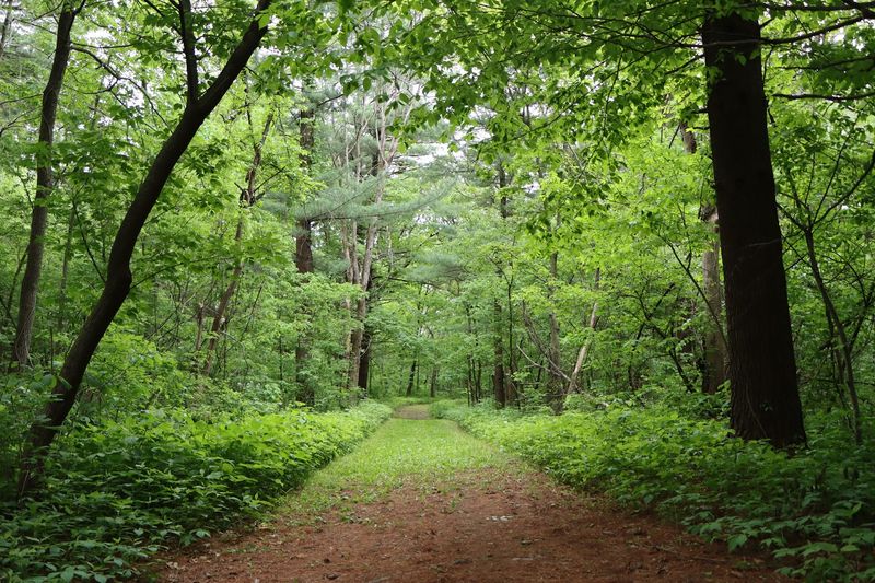
Trail maps at Wyalusing show a network that could keep dedicated hikers busy for days. The 14-plus miles divide into routes ranging from easy strolls to challenging climbs that test your cardiovascular fitness.
Each trail connects to others, allowing creative loop combinations that prevent backtracking.
Markers appear frequently enough to prevent getting lost, though some junctions require attention to signage. The trails visit different ecosystems as elevation changes, moving from riverside lowlands through hardwood forests to exposed bluff tops.
Spring wildflowers bloom in succession along different routes, giving botanically minded hikers reasons to return throughout the season.
Trail conditions vary considerably based on recent weather and seasonal maintenance schedules. Some paths cross rocky sections that demand proper footwear, while others follow gentle grades suitable for families with young children.
Winter transforms the system into snowshoe routes, though the park warns about icy conditions near bluff edges during freezing months.
Mississippi Ridge Trail Ends With A Huge River View
This particular trail builds anticipation with every step, saving its best moment for the finale. The path winds through woods that block views for most of the journey, making the sudden openness at trail’s end feel even more dramatic.
Hikers emerge from tree cover to find the entire Mississippi River valley spread out like a relief map.
The overlook sits at a spot where the river bends, providing sightlines both upstream and downstream. Binoculars reveal details on distant shorelines and help identify waterbirds working the shallows.
Benches allow tired hikers to rest while absorbing scenery that changes character as the sun moves across the sky.
Late afternoon brings particularly good light for photography, with long shadows defining the landscape’s contours. The trail measures moderate in difficulty, requiring some uphill effort but rewarding average fitness levels.
Rangers recommend bringing water because the exposed overlook offers no shade during summer heat.
Bluff Trail Packs Big Scenery Into Less Than One Mile
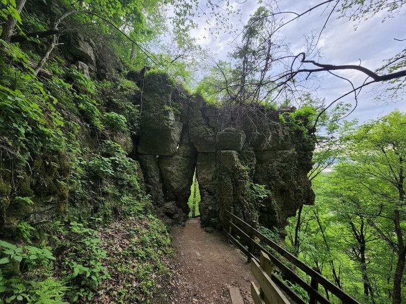
Distance matters far less than intensity on this compact route. The Bluff Trail squeezes remarkable scenery into a walk that takes under an hour at a leisurely pace.
Starting near the concession area, the path follows the cliff edge closely enough to make cautious hikers nervous.
Rock formations jut out at intervals, creating natural viewing platforms above the sheer drop. The trail narrows in spots, with vegetation crowding from one side and empty air on the other.
Parents with small children often choose to skip this route or maintain very firm hand-holding throughout.
Geology becomes visible in the exposed rock layers that tell stories of ancient seas and sediment deposits. The trail delivers multiple overlooks rather than just one destination view, meaning you stop frequently rather than pushing toward a single goal.
Sunset walkers claim this route for evening light that sets the rivers glowing, though returning after dark requires flashlights and careful footing on the uneven surface.
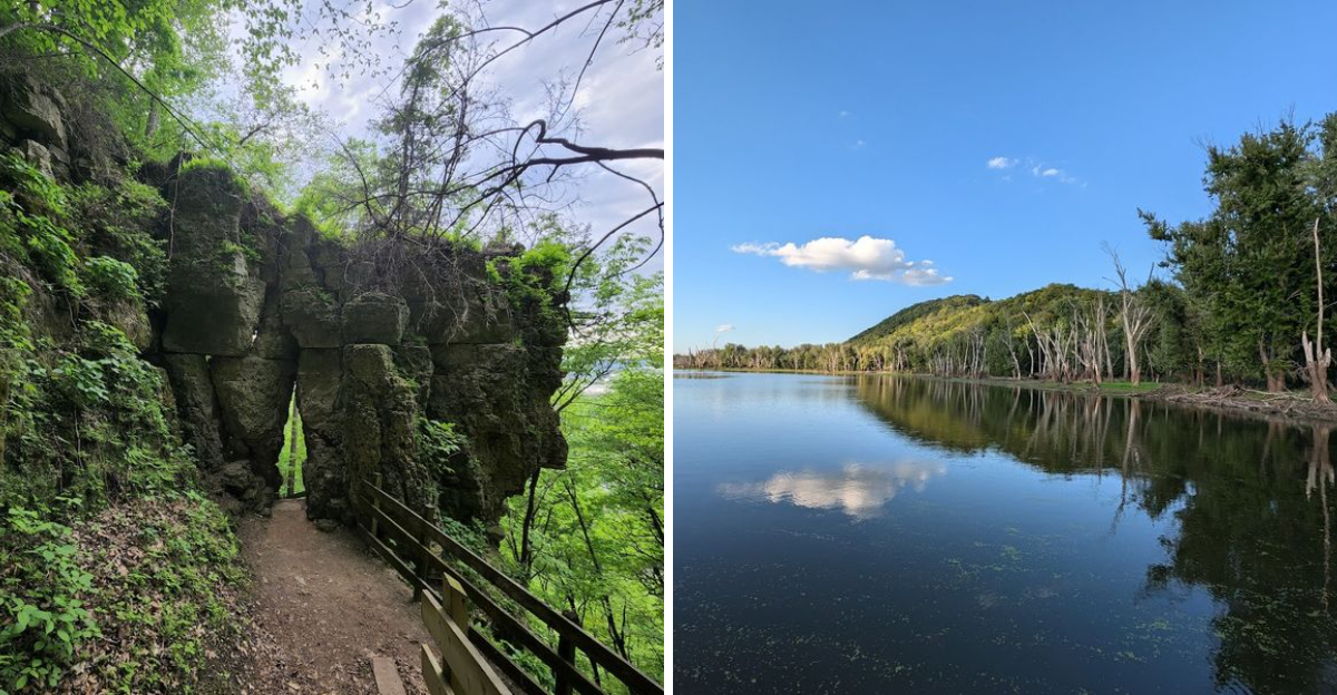
Sand Cave Trail Adds A Different Kind Of Trail Surprise
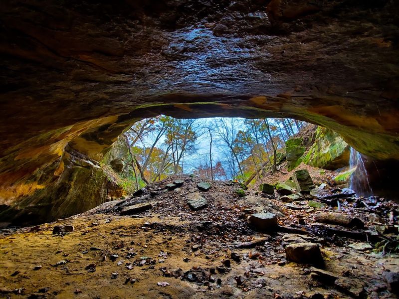
Caves in Wisconsin do not typically make tourist brochures, which makes discovering this formation particularly satisfying. The Sand Cave Trail descends from the bluff top through switchbacks that ease the elevation change.
Trees shade most of the route, keeping temperatures comfortable even when the overlooks bake in summer sun.
The cave itself formed through erosion of soft sandstone, creating an overhang deep enough to shelter dozens of people from rain. Ancient travelers likely used this spot for exactly that purpose over countless generations.
The cool air flowing from the cave provides natural air conditioning that feels wonderful after the hike down.
Rock walls show layering and weathering patterns that geology students find fascinating. The cave stays closed during bat hibernation season to protect vulnerable wildlife populations.
Spring visitors sometimes encounter small waterfalls near the cave as snowmelt finds paths through the rock, adding temporary features to the already interesting landscape.
Native American Burial Mounds Add History To The Landscape
Walking past these earthworks connects visitors to people who shaped this landscape over a thousand years ago. The mounds at Wyalusing include effigy forms built to resemble animals, a practice specific to certain indigenous cultures of the upper Mississippi valley.
Informational signs explain the mounds without sensationalizing or disrespecting their sacred nature.
Some mounds remain obvious to casual observers, while others require trained eyes to distinguish from natural terrain features. The park protects these sites carefully, with trails routed to provide views without allowing foot traffic directly on the ancient structures.
Archaeologists have documented the mounds extensively, adding Wyalusing to the larger story of Woodland period cultures.
Spring and fall provide the best times to see mound shapes clearly, when low vegetation and angled sunlight reveal subtle contours. The mounds remind modern visitors that this scenic beauty attracted human attention long before state parks existed.
Respectful observation remains the only appropriate response to these burial sites that predate European contact by centuries.
Birdwatching Makes The Trails Even More Interesting
Serious birders arrive at Wyalusing with checklists and high hopes for their life lists. The park sits along the Mississippi Flyway, making it prime territory during spring and fall migrations.
Bald eagles nest in the area and hunt the rivers year-round, providing reliable sightings that thrill first-time eagle watchers.
The varied habitats support different bird communities, from forest interior species to water-loving herons and egrets. Early morning hours produce the most activity and the best light for photography.
The park maintains a bird list documenting species observed over the years, showing remarkable diversity for a relatively small area.
Experienced birders know to check the backwater areas accessible by the canoe trail, where secretive marsh birds hide among vegetation. Warblers pass through in waves during May, creating colorful challenges for identification.
Winter brings its own specialties, including owls and northern finches that move south when food grows scarce in Canada, making Wyalusing a four-season destination for anyone carrying binoculars.
The Canoe Trail Shows The Park From The Water
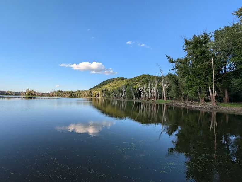
Renting a canoe at the park concession opens up perspectives impossible to gain from land trails. The designated water trail winds through backwater channels where the current barely moves and wildlife ignores passing paddlers.
The route divides into north and south sections, with the northern loop earning praise for eagle sightings and scenic variety.
Three hours gives most paddlers enough time to complete the full trail with stops for photos and wildlife observation. The water remains calm enough for beginners, though wind can create challenges on open sections.
Rental rates stay reasonable, and the concession provides basic paddling instructions for those new to canoeing.
Great blue herons stalk the shallows, freezing when canoes approach, then exploding into flight with prehistoric-looking wingbeats. The water trail passes under the bluffs that hikers walk above, showing how dramatically the landscape changes between river level and overlook height.
Turtles sun themselves on logs, and fish occasionally jump, creating ripples that spread across the mirror-smooth backwaters.
Wyalusing Feels Like One Of Wisconsin’s Most Complete Outdoor Escapes
Few parks pack this much variety into one location. Campers wake to river views from sites perched along the bluff edge, then spend days exploring without ever feeling they have exhausted the possibilities.
The combination of water access, extensive trails, historical sites, and dramatic scenery creates experiences that satisfy different interests within the same family or friend group.
Facilities maintain high standards without feeling overdeveloped or commercialized. The shower buildings earn consistent praise for cleanliness and design, while the concession operation provides necessities without cluttering the natural setting.
Dark skies make the park popular with astronomers who appreciate the distance from city light pollution.
Advance reservations become necessary for summer weekends, as word spreads about this underrated destination. The park opens at 6 AM and closes at 11 PM daily, giving visitors long days to explore.
Despite growing popularity, Wyalusing retains a peaceful character that busier parks sacrifice, making it the kind of place people return to year after year.