The 4.5-Mile Wisconsin Trail That Reveals Jaw-Dropping Cliffs And Sea Caves At The End
Along the southern shore of Lake Superior in northern Wisconsin, a trail unfolds that rewards patient hikers with some of the most dramatic coastal scenery in the entire Midwest. Part of the Apostle Islands National Lakeshore, this 4.5-mile round-trip trail winds through dense forest before reaching a rugged sandstone shoreline shaped by centuries of wave action.
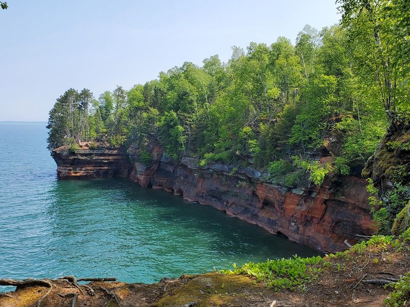
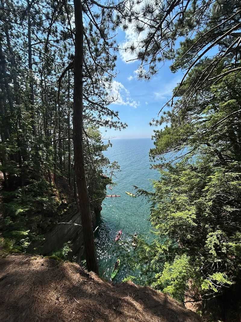
Towering amber cliffs rise above the shoreline, while cavernous sea caves carved by Lake Superior stretch beneath them, some large enough for kayakers to paddle straight through. Every step along this path builds toward that dramatic moment when the rugged coast finally comes into view.
A Scenic 4.5-Mile Hike Along Lake Superior
Few trails in the Upper Midwest offer the kind of sustained visual payoff that the Meyers Beach Sea Cave Trail delivers from start to finish. The path begins at the Meyers Beach trailhead and follows the Lakeshore Trail northeastward, weaving through a canopy of hardwoods and conifers before the forest gradually opens toward the lake.
The round trip covers approximately 4.5 miles, making it manageable for most adults with reasonable fitness. Elevation changes are moderate for the first mile, then the trail descends into several steep gullies, each requiring careful footing especially after rain.
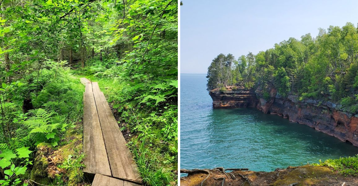
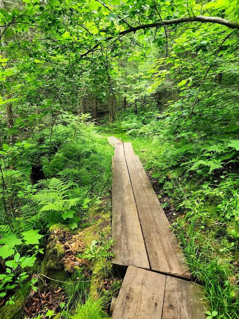
Wooden plank boardwalks line much of the first mile, keeping feet dry and the experience comfortable. A five-dollar daily parking fee applies at the trailhead, and restrooms along with running water are available near the parking area for visitor convenience.
One Of Wisconsin’s Most Famous Sea Cave Trails
The Apostle Islands National Lakeshore manages some of the most geologically compelling coastline in the country, and the Meyers Beach trail stands as one of its most celebrated access points. Hikers and paddlers alike make the trip to Bayfield specifically because this trail leads to the mainland sea caves, a formation found nowhere else in Wisconsin.
The National Park Service maintains the route with care, placing benches at strategic viewpoints and keeping the boardwalk sections in solid condition. Rangers are stationed at the trailhead during operating hours, ready to answer questions and confirm that kayakers heading out on the water are properly equipped.
The trail earns its reputation not through spectacle alone but through the full sensory experience it provides. The smell of pine, the sound of waves crashing against sandstone, and the gradual reveal of the caves make each visit genuinely memorable.
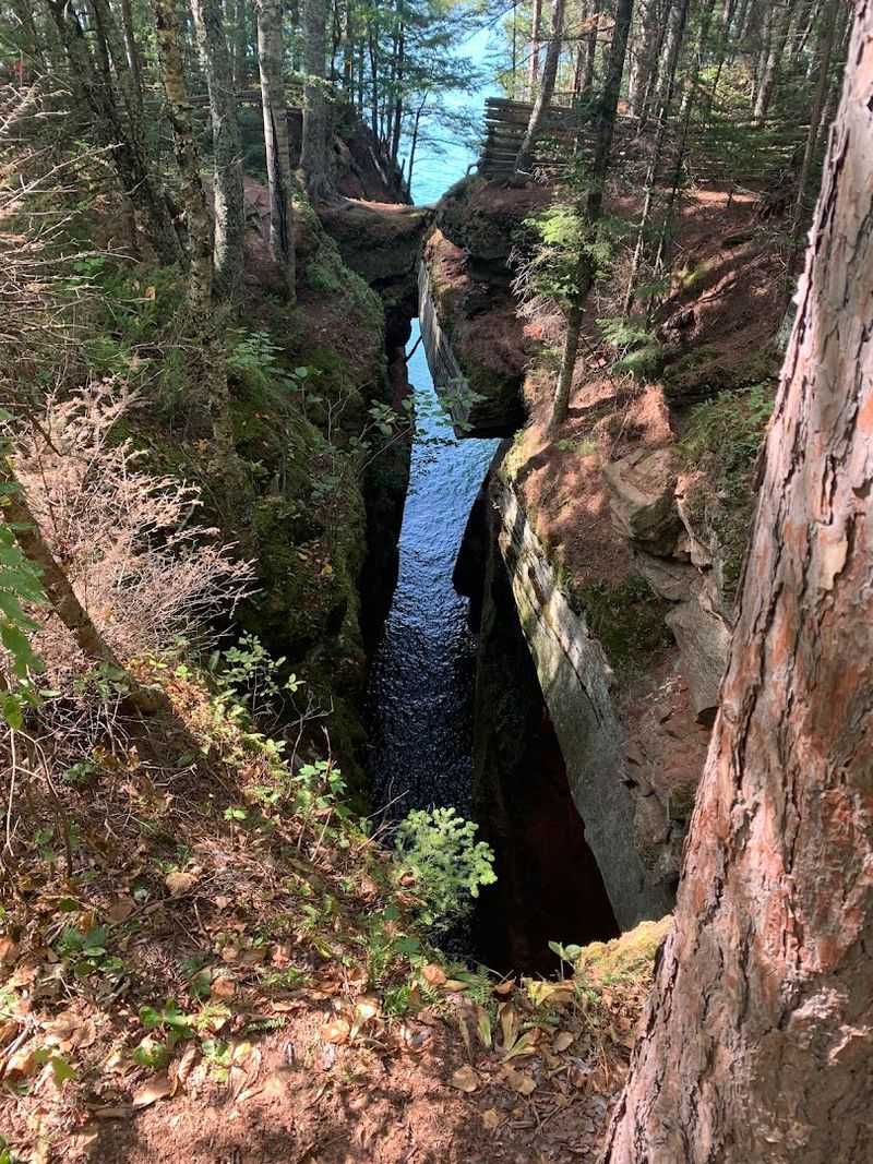
Towering Sandstone Cliffs Shaped By Waves
What makes the cliffs along this trail so visually striking is the warm reddish-brown hue of the Orienta sandstone, a sedimentary rock that formed roughly 500 million years ago and has been sculpted ever since by the relentless force of Lake Superior. The vertical faces rise impressively from the waterline, streaked with mineral deposits and draped in moss where moisture collects.
Standing at one of the trail overlooks and looking down at the water churning against the base of these formations gives a clear sense of how patient geology truly is. Each wave that strikes the cliff face carries away microscopic fragments, slowly reshaping what visitors see today.
The best cliff views appear between miles 1.7 and 2.5 of the trail, where the forest pulls back and the lake opens wide. A solar-powered camera installed by the National Park Service marks roughly the 4.4-mile round-trip point near the caves.
The Mainland Sea Caves At Meyers Beach
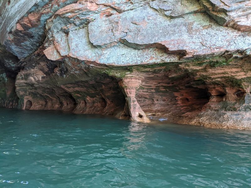
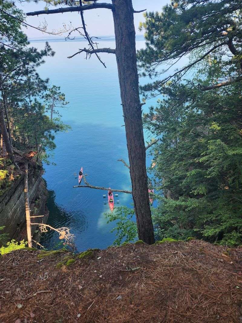
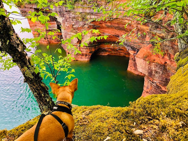
The mainland sea caves are the undeniable centerpiece of this entire trail experience. Carved directly into the sandstone bluffs by thousands of years of wave action and freeze-thaw cycles, these caves range from shallow alcoves to deep chambers with openings wide enough for a kayak to pass through comfortably.
From above, hikers can peer through gaps in the cave roofs and look straight down into the lake below, a perspective that surprises even experienced trail walkers. The main cave, visible from a well-positioned bench near the overlook, is particularly impressive in its scale and depth.
Kayak companies launch tours directly from Meyers Beach, taking small groups into the caves at water level for an entirely different vantage point. The address for the trailhead is Meyers Beach Road, Bayfield, WI 54814, and the NPS visitor contact number is (715) 779-3397 for trip planning purposes.
A Forest Trail That Leads To A Dramatic Shoreline
For the first mile or so, the Meyers Beach trail behaves like a classic Northwoods forest walk. The canopy overhead filters light into soft patterns on the ground, and the boardwalk sections keep the path clean and accessible even when recent rain has softened the soil.
Blue bead lilies and bunchberry plants bloom along the edges in mid-June, adding quiet color to the understory.
This forested opening stretch gives hikers time to settle into a rhythm before the terrain becomes more demanding. The gullies that appear in the second half of the trail require descending and climbing short but steep slopes, with exposed tree roots and uneven steps adding an element of genuine challenge.
Bug repellent is strongly recommended, as the damp forest environment supports a healthy mosquito population through summer. The humidity inside the tree cover amplifies the warmth considerably, so carrying water from the start is a practical necessity rather than an afterthought.
Sea Caves Large Enough To Explore By Kayak
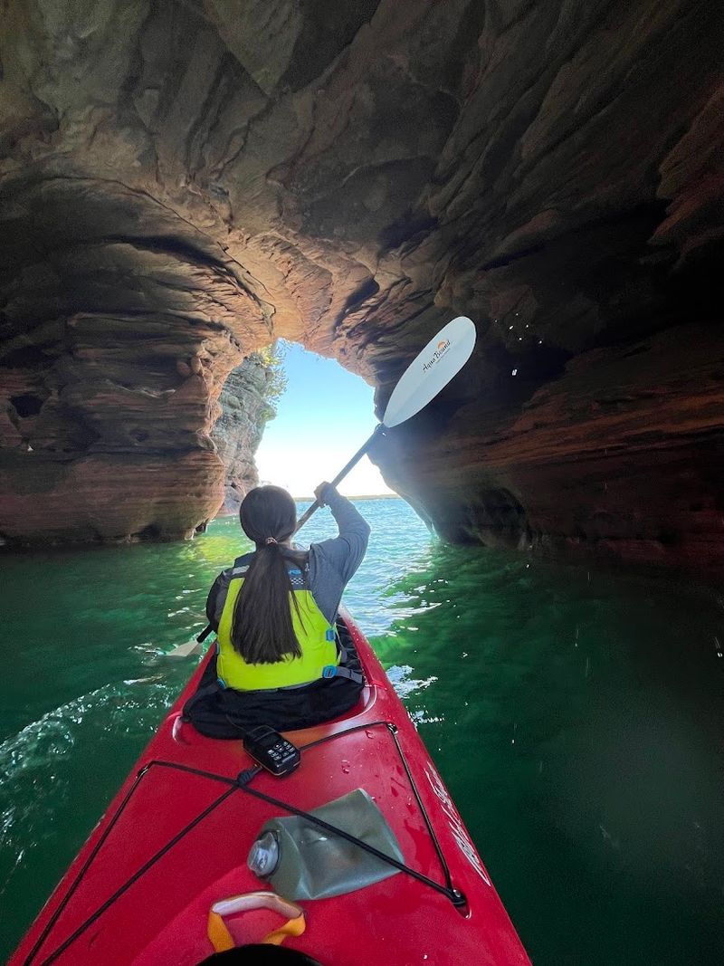
Paddling into the mainland sea caves from the water is an experience that reframes everything a hiker sees from the cliff top. The cave openings are wide and tall enough to accommodate tandem kayaks with ease, and the acoustics inside shift noticeably as the rock walls surround the paddler on three sides.
Several kayak outfitters operate tours directly from Meyers Beach, offering guided group experiences for visitors who prefer not to navigate independently. Rental equipment is available, though the water temperature in Lake Superior stays cold year-round, making a wetsuit or dry suit a sensible precaution regardless of air temperature.
On foggy mornings, the atmosphere inside the caves takes on a particular quality that clear days simply cannot replicate. The mist softens distances, muffles sound, and gives the sandstone walls a deeper, more saturated color that photographers and paddlers both find worth the early start and the drive to Bayfield.
Some Of The Best Lake Superior Views In Wisconsin
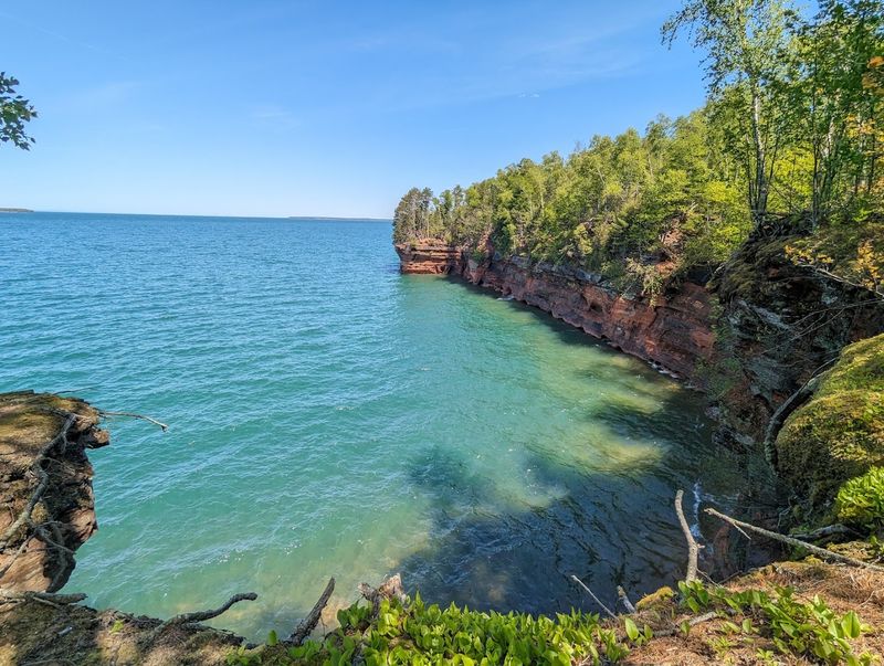
Lake Superior is the largest freshwater lake in the world by surface area, and standing at one of the trail overlooks near the sea caves makes that scale feel entirely believable. The water extends to the horizon in a shade of blue that shifts depending on cloud cover, time of day, and wind conditions, never quite the same twice.
On clear mornings, the distant silhouettes of the Apostle Islands themselves are visible from the cliff-side viewpoints, adding geographic depth to what is already a compelling scene. The quality of light just after sunrise turns the sandstone cliffs a warm amber that photographs extremely well and lingers in memory long after the hike ends.
After 5 p.m. on summer evenings, the beach and overlook areas quiet considerably, offering a more contemplative experience than the midday rush. Sunsets from this section of shoreline are particularly rewarding, with the western light catching the water at low angles.
A Favourite Spot For Photographers
The combination of geological drama, clear lake water, and changing seasonal conditions makes the Meyers Beach trail one of the most reliably photogenic locations in all of Wisconsin. Morning light hits the sandstone faces at an angle that reveals texture and color depth that midday sun simply flattens out.
The cave rooftop openings, where hikers look directly down through gaps in the rock into the water below, create framing opportunities that few other trail destinations in the Great Lakes region can match. Wide-angle lenses capture the full scope of the cliff lines, while telephoto options pull in the cave details from the established overlook benches.
Starting the hike before 6 a.m. on weekdays virtually guarantees solitude for the first half of the trail, a genuine advantage for photographers who need a still scene. The NPS-installed solar camera near the 4.4-mile round-trip mark is worth noting as a landmark when planning shot locations along the route.
Winter Turns The Caves Into A Frozen Wonderland
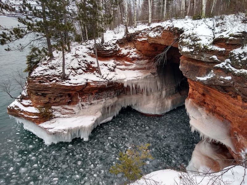
When temperatures drop far enough in January and February, the mainland sea caves transform into something that looks borrowed from a Scandinavian fairy tale. Lake spray freezes against the cave walls and ceilings, building elaborate formations of blue and white ice that grow thicker with each cold snap.
The trail remains accessible in winter, though the first several hundred yards can ice over significantly and traction devices such as microspikes or YakTrax are strongly advised. Beyond the first mile, foot traffic decreases and the trail surface softens, but caution remains necessary throughout the route.
Winter hiking here carries a different rhythm than summer visits. The forest is quieter, the light is low and directional, and the caves reward the effort with formations that melt away completely by spring.
The NPS monitors ice conditions and posts updates when cave access is safe, making it worth checking before planning a cold-weather trip to Bayfield.
Sandstone Formations That Change Over Time
The sandstone that forms these cliffs and caves is not static. Every season, freeze-thaw cycles crack the rock face in new places, wave action undercuts the cliff bases, and sections of overhang eventually collapse into the lake below.
What visitors see today is a snapshot of an ongoing geological process that began long before the first human set foot on this shoreline.
Geologists identify the rock here as Orienta sandstone, deposited during the Precambrian era and compressed over hundreds of millions of years into the layered formations visible along the trail. The horizontal banding in the cliff faces reflects ancient sediment layers, each representing a distinct period of deposition.
Returning to this trail across multiple years reveals subtle but real changes in the cave shapes and cliff profiles. The NPS documents these shifts as part of ongoing resource monitoring, treating the caves not as permanent fixtures but as living landforms that the park actively studies and protects for future generations.