This Tennessee Waterfall Appears From A Cave And Vanishes Like Magic
Some waterfalls follow a predictable path. Water flows from a stream, drops over a ledge, then continues downhill.
This one skips a few steps. It emerges straight out of a cave opening, falls in a striking display, then disappears back underground before it ever forms a visible stream.
Tennessee is full of scenic spots, but this combination of cave and cascade stands out as unusual. There’s no obvious source feeding it and no river carrying the water away afterward.
Visitors who make the hike often pause here longer than expected, trying to piece together how the whole system works.
The trail leading to it isn’t short, and it asks for a reasonable level of fitness and planning. Still, reaching the falls makes the effort worthwhile.
Standing near the cave mouth as water pours out gives you a small puzzle to think about, one that doesn’t need embellishment to feel interesting.
Why This Cave And Cascade Combination Is So Rare
Most waterfalls follow a predictable story. Rain falls, rivers form, water finds a cliff, and gravity does the rest.
This one skips most of that story entirely. The water feeding this falls travels through an underground network of limestone passages before bursting out of a cave opening high on a cliff face.
This region of White County, Tennessee, sits on karst geology, a type of landscape shaped by centuries of rainwater slowly dissolving soluble limestone bedrock.
Over time, that dissolution creates caves, sinkholes, and subterranean drainage systems that behave more like plumbing than geography.
Water moves invisibly through the rock until it finds an exit.
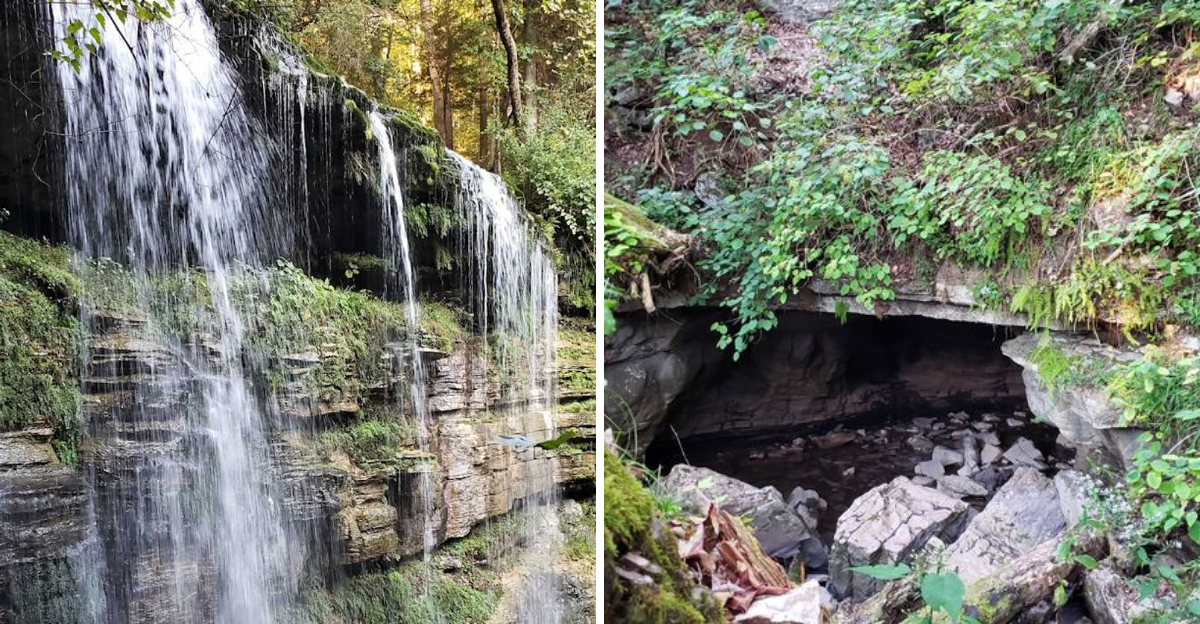
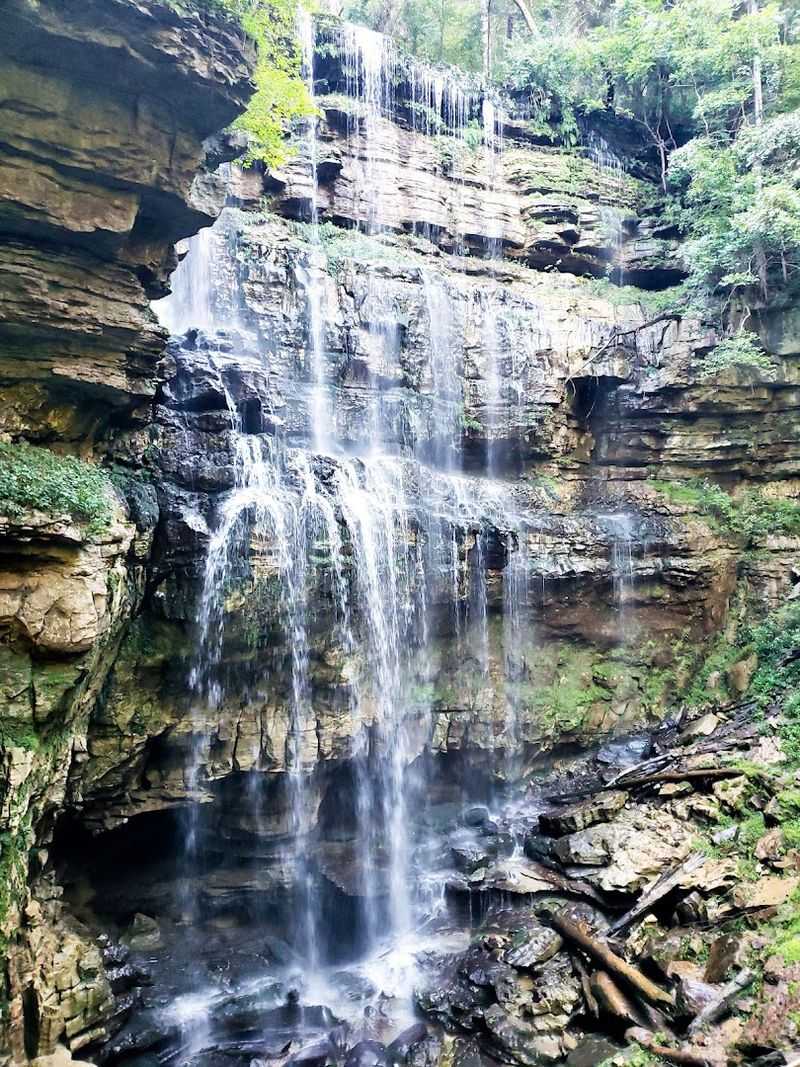
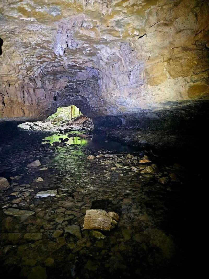
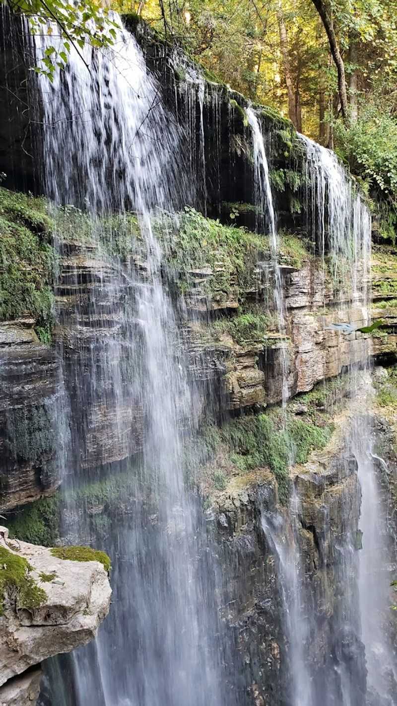
At these falls, that exit is dramatic. The underground stream emerges from the cave mouth, free-falls approximately 110 to 120 feet, and then vanishes into another cave at the base of the sink.
There is no pool that spills into a creek. The water simply disappears. Scientists call this a losing stream. Hikers call it astonishing.
Understanding the geology makes the visual experience even more rewarding, because you realize the waterfall exists as a brief, visible interruption in a much longer underground journey.
A Look At The Trail From Beginning To End
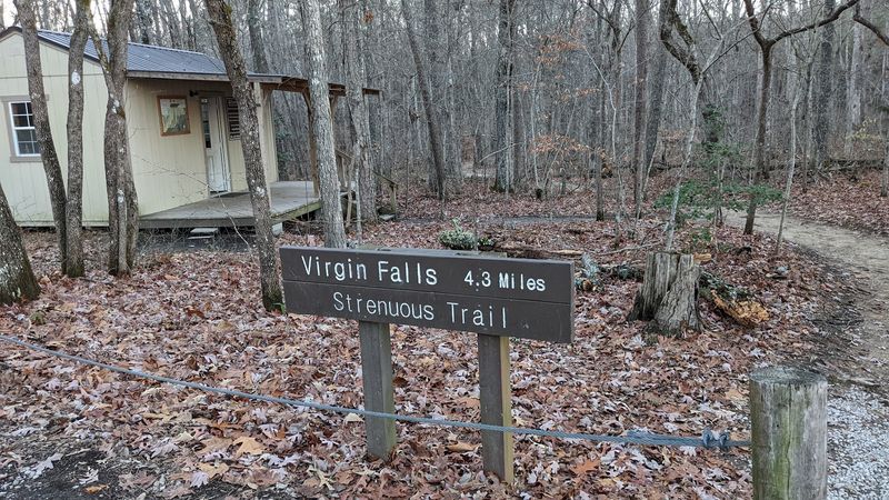
The Virgin Falls Trail runs approximately 4 to 4.3 miles one way, making the full out-and-back hike between 8 and 9 miles total. That number alone tells you this is a commitment.
Plan for a full day, bring more water than you think you need, and start early. The trail is located in Tennessee 38583, within the Virgin Falls State Natural Area.
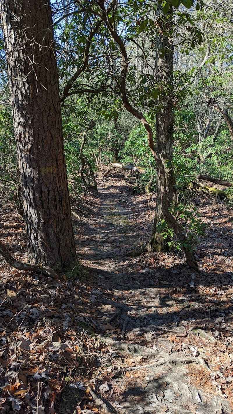
The first 1.5 miles are deceptively pleasant. The path is flat, wide, and easy enough for most fitness levels. Enjoy it. After that stretch, the trail drops into the valley, and the terrain shifts considerably.
Rocks and exposed tree roots become constant companions, requiring steady footing and a watchful eye.
Elevation changes, narrow passages, and uneven ground make this trail legitimately strenuous. Hiking boots with ankle support are strongly recommended.
Trekking poles help on the descent sections. The trail is well-marked but not manicured, so expect a raw, unpolished hiking experience rather than a groomed nature walk.
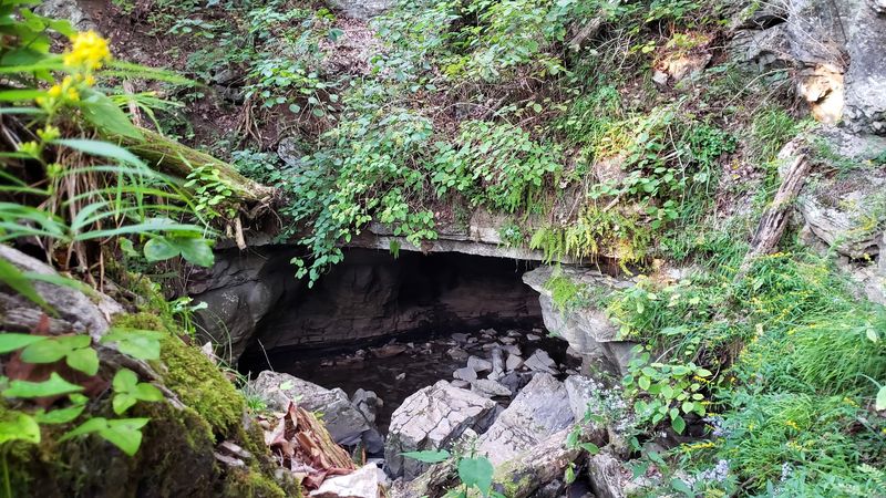
The reward for all that effort comes in stages. Big Laurel Falls appears at roughly the halfway point, offering a natural rest stop with its own impressive cave.
Virgin Falls waits at the end, and it more than justifies the miles behind you.
Big Laurel Falls And The Caves Along The Way
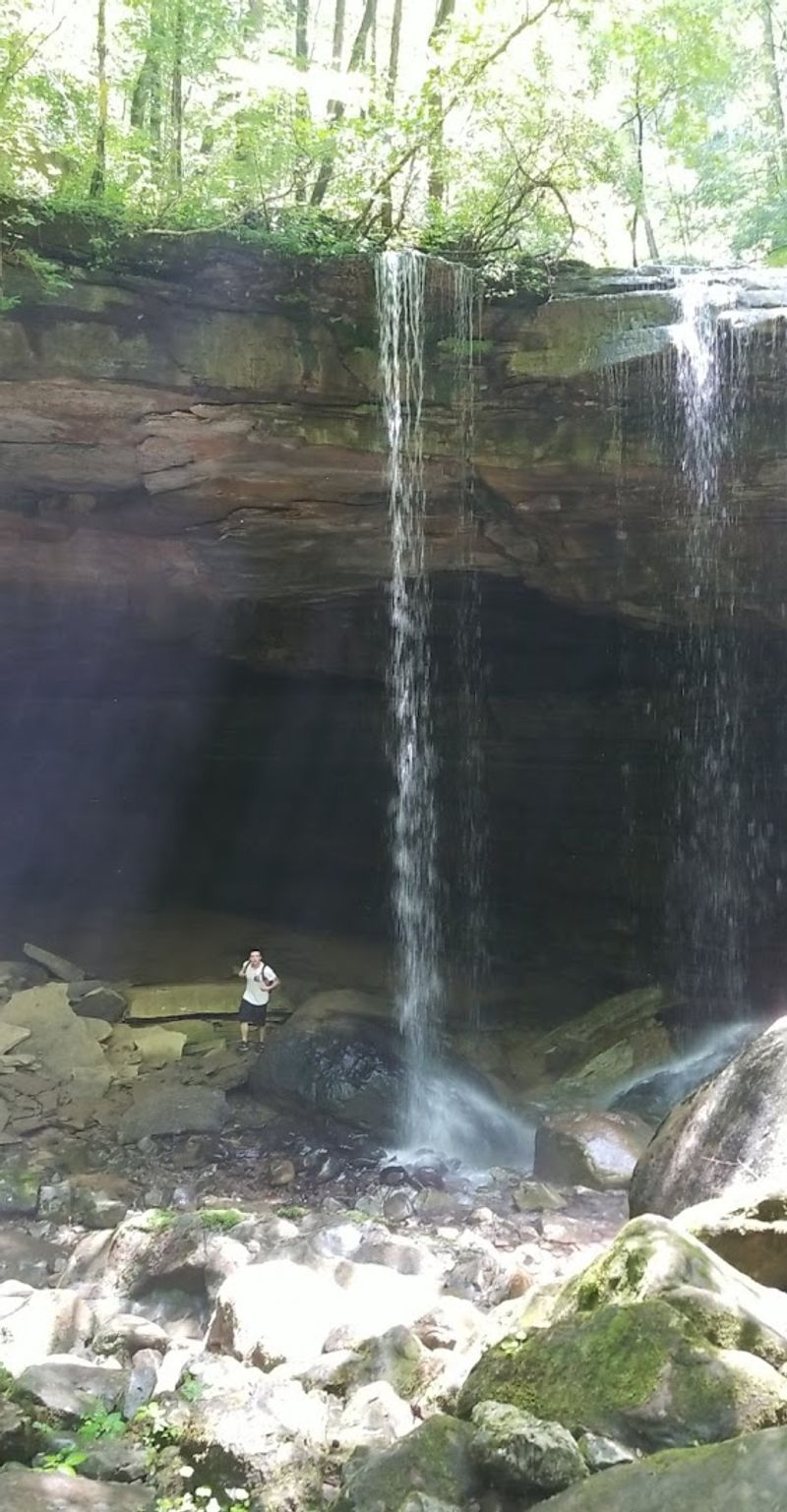
Halfway through the trail, Big Laurel Falls earns your full attention.
This waterfall is wide, confident, and framed by a large cave opening directly beneath it, which gives the whole scene an almost theatrical quality.
Standing in front of it, you can feel the mist and hear the cave breathing cool air outward.
Big Laurel Falls is not a footnote on this hike. It is a destination in its own right, and many hikers stop here for a genuine rest before continuing toward Virgin Falls.
The cave beneath the falls is visually striking, and the sound of water echoing inside the rock adds a layer of atmosphere that photographs struggle to capture.
Beyond Big Laurel, the trail also passes Sheep Cave Falls and Big Branch Falls, each with its own personality and geological quirk. The concentration of waterfalls along this single trail is unusual even by Tennessee standards.
Most hikes offer one centerpiece. This trail offers several, building anticipation with each new discovery.
Exploring these intermediate waterfalls also gives hikers a practical sense of the karst system at work. Each one tells part of the same underground story, making the final reveal of Virgin Falls feel like the last chapter of a very satisfying book.
The Moment You First See Virgin Falls
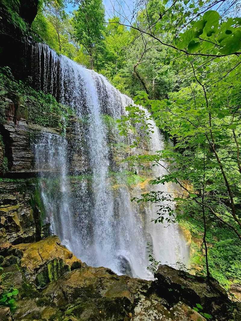
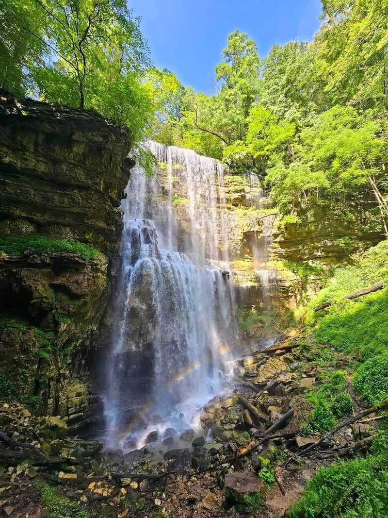
Nothing on the trail fully prepares you for the first sighting of Virgin Falls. You hear it before you see it.
The sound builds gradually, a deep, consistent roar that grows louder as you approach the overlook. Then the trees open up, and there it is.
Water pours out of a cave opening in the cliff face and drops roughly 110 to 120 feet straight down into a rocky basin. There is no pool at the bottom collecting the water.
There is no stream flowing away. The water hits the rocks and disappears into the earth through a lower cave opening, leaving the basin dry except for mist and scattered spray.
The visual effect is genuinely disorienting. Your brain expects a pool.
It expects a river. When neither appears, you find yourself staring longer than usual, trying to reconcile what your eyes are showing you with what you know about how water behaves.
Many hikers also climb to the top of the falls, which adds a short but worthwhile detour. From above, you can peer over the edge and look down into the sink, gaining a perspective that makes the disappearing act even more vivid.
It is one of those rare moments when a natural place exceeds its reputation.
Scott’s Gulf And The Landscape That Surrounds The Falls
Virgin Falls does not exist in isolation. It sits within a much larger geographical story, one shaped by the Caney Fork River and its tributaries over millions of years.
Scott’s Gulf is an 18-mile canyon carved through the Cumberland Plateau, and the Virgin Falls State Natural Area occupies 1,157 acres within its boundaries.
The canyon walls, dense forest canopy, and layered limestone cliffs give the entire area a sense of depth and age. This is not a landscape that was shaped recently.
Every rock formation, every sinkhole, every cave entrance reflects an enormous span of geological time, and the trail passes through it all at a pace slow enough to actually notice.
In 2025, Virgin Falls became part of Scott’s Gulf Wilderness State Park, expanding its protected status and drawing greater attention to the broader canyon system.
The designation reflects the ecological and geological significance of the area, which supports diverse plant communities, wildlife habitats, and a bat population of considerable importance.
Hiking through Scott’s Gulf feels different from hiking in more accessible Tennessee parks.
The terrain is less forgiving, the solitude is more pronounced, and the sense that you are somewhere genuinely remote stays with you throughout. That remoteness is part of what makes the experience so memorable.
Bat Conservation And Why The Caves Are Closed
The caves along the Virgin Falls Trail are visually compelling and ecologically critical.
Several species of bats use these caves for hibernation, and they are currently under serious threat from White-Nose Syndrome, a fungal disease that has devastated bat populations across North America since it was first identified in 2006.
White-Nose Syndrome spreads easily through caves, and human visitors can unknowingly carry the fungus on clothing and gear.
To protect the remaining bat colonies, many caves in the Virgin Falls State Natural Area, including Virgin Falls Cave itself, are closed to public recreational entry.
These closures are not arbitrary. They reflect a genuine conservation need supported by wildlife biologists.
Bats play an outsized role in the health of forest ecosystems. A single bat can consume thousands of insects per night, providing natural pest control that benefits both agriculture and forest regeneration.
Losing bat colonies has measurable consequences that extend well beyond the caves themselves.
Visitors who respect the cave closure signs are actively participating in conservation, even if it does not feel that dramatic in the moment.
The closures allow bat populations to stabilize without the additional stress of human disturbance.
Appreciating the falls from the outside is a reasonable trade for the preservation of something far more fragile and important.
Camping Options Inside The Natural Area
For hikers who want more than a single day at Virgin Falls, the natural area offers backcountry camping at three designated campsites near the falls. Staying overnight transforms the experience considerably.
The trail empties of other hikers as evening arrives, and the sound of the falls carries through the dark in a way that feels almost private.
Reservations for campsites must be made through the Tennessee State Parks website, and fees are modest. The sites are basic by design.
There are no electric hookups, no camp stores, and no amenities beyond what the forest provides. Campers carry everything in and carry everything out.
Of the three available sites, only one is reliably level enough for comfortable tent placement, which is worth factoring into your planning. Arriving early gives you the best chance of claiming that spot.
The other sites work with creative tent positioning and a tolerance for slightly uneven ground.
Spending a night near Virgin Falls also gives you the rare opportunity to hear the waterfall after dark.
The surrounding forest quiets down, and the falls become the dominant sound, a steady, unhurried roar that continues regardless of the hour. It is a genuinely restorative way to end a demanding hiking day.
History Of The Land And Its Protected Status
The land surrounding Virgin Falls has been recognized as exceptional for decades.
In 1973, the area was designated a Pocket Wilderness by Bowater Incorporated, a paper company that owned the land and chose to protect it rather than develop it.
That designation reflected an early understanding of the area’s ecological and scenic value.
Decades later, the State of Tennessee acquired the property in 2012, with financial support from a grant provided by the U.S. Fish and Wildlife Service.
The acquisition formalized the land’s protection and opened it to public access under state management. The transition from private wilderness designation to state natural area brought improved trail maintenance and official campsite management.
The most recent chapter in this history came in 2025, when Virgin Falls became part of Scott’s Gulf Wilderness State Park.
This expanded designation connects the natural area to the broader canyon system and signals a long-term commitment to preserving the region’s geological and biological resources.
Understanding this history adds meaning to the hike itself. The trail you walk today exists because people made deliberate choices over several decades to protect it.
That continuity of care is visible in the forest’s maturity, the clarity of the water, and the undisturbed quality of the landscape that greets every visitor who makes the trip.
Getting Ready For The Hike Ahead
Preparation makes the difference between a miserable slog and an exceptional day out. The Virgin Falls Trail is classified as strenuous, and that classification is accurate.
An early start is essential. Arriving at the trailhead by 7 or 8 in the morning gives you enough daylight to complete the hike comfortably, enjoy the falls, and return without rushing.
Water is the most commonly underestimated supply on this trail. Bring at least two liters per person, more if the weather is warm.
There are no water sources along the trail that are safe to drink without treatment. Food matters too.
The 8 to 9-mile round trip burns significant energy, and a proper meal or substantial snacks will keep your pace steady on the return leg.
Footwear deserves serious thought. The trail surface includes exposed roots, loose rocks, and muddy sections after rain.
Trail runners work for experienced hikers, but stiff-soled hiking boots with ankle support are the more forgiving choice for most people. Trekking poles help considerably on the steeper descent sections.
Cell service in this area is unreliable. Download an offline map before you leave, let someone know your plans, and carry a basic first aid kit.
The trail is well-marked, but self-sufficiency is always the smarter approach in a place this remote and rewarding.