This Wisconsin Park Is A Relaxing Escape With Streams And Forest Trails
Wyalusing State Park sits high on bluffs above the Mississippi River in southwestern Wisconsin, offering visitors a peaceful retreat into nature. The park combines dramatic river views with quiet forest paths, creating a destination that feels both grand and intimate.
Trails wind through ancient woodlands, and overlooks open up to sweeping water views. This protected landscape has drawn people for thousands of years and still offers a welcome break from everyday life.
Where Two Mighty Rivers Meet In A Peaceful Natural Setting
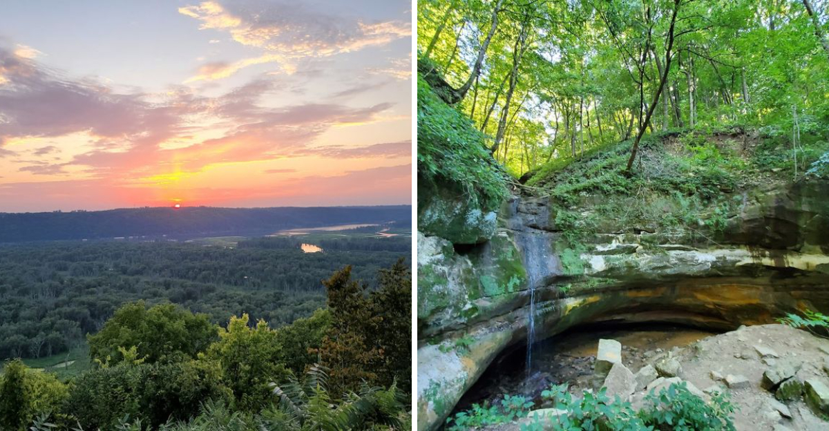
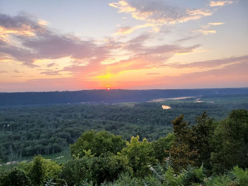
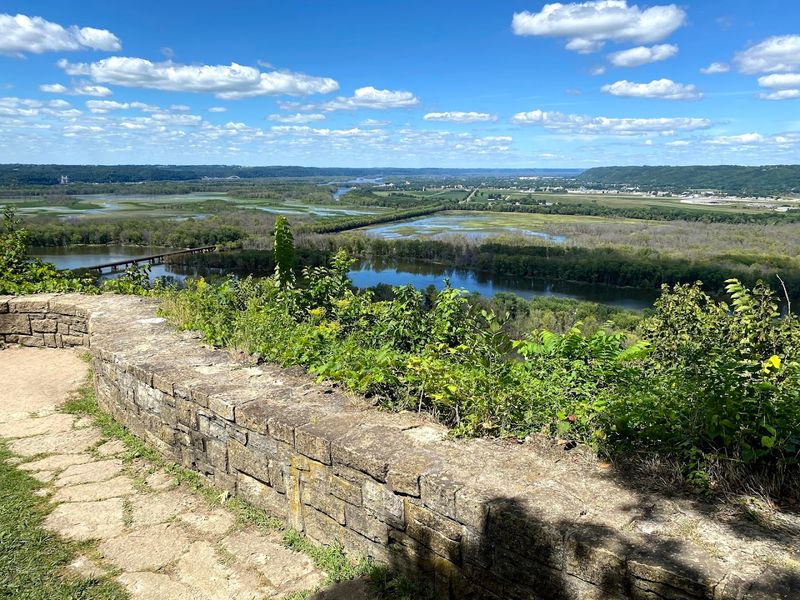
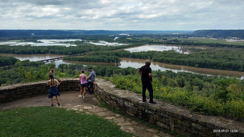
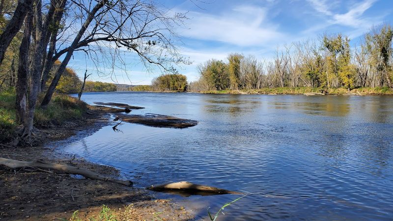
Standing at Point Lookout, you can watch two of America’s most famous rivers join forces. The Wisconsin River flows into the Mississippi here, creating a natural spectacle that has shaped the landscape for millennia.
The view from the bluff stretches for miles, revealing sandbars, backwater channels, and the broad sweep of both waterways.
Early morning visits often bring fog that clings to the river valleys, slowly lifting to reveal the full scope of the confluence. The colors shift throughout the day as sunlight moves across the water.
Eagles circle overhead, taking advantage of the rich fishing grounds where these currents meet.
The park’s location at 13081 State Park Lane in Bagley places it perfectly for observing this geographic feature. Photographers arrive before dawn to capture the moment when light first touches the water.
The confluence serves as a reminder of how rivers have always guided human settlement and movement through the continent.
Forest Trails That Wind Through Quiet Hills And Hidden Corners
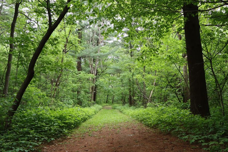
The trail system at Wyalusing covers more than 28 miles, threading through forests that change character as you move from ridge to valley. Sugar maples dominate many sections, their trunks rising straight and tall before spreading into a leafy canopy.
Oak and hickory trees add variety, while the understory fills with ferns and wildflowers depending on the season.
Some paths follow the contour of the bluffs, offering relatively easy walking with occasional glimpses through the trees. Others plunge down steep slopes via switchbacks, losing hundreds of feet in elevation as they descend toward the river.
The trail surfaces vary from packed earth to exposed rock, requiring attention but rarely demanding technical skill.
Signage appears at most intersections, though a trail map proves useful for planning longer loops. The forest remains quiet except for birdsong and the rustle of leaves.
Hikers often have entire sections to themselves, particularly on weekday mornings when the park sees fewer visitors.
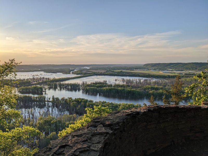
Gentle Streams And Natural Springs Add To The Park’s Relaxing Atmosphere
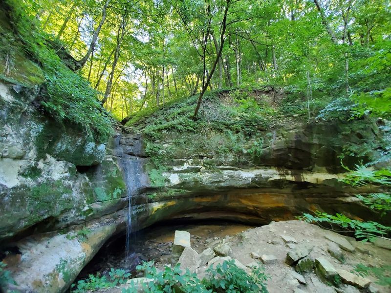
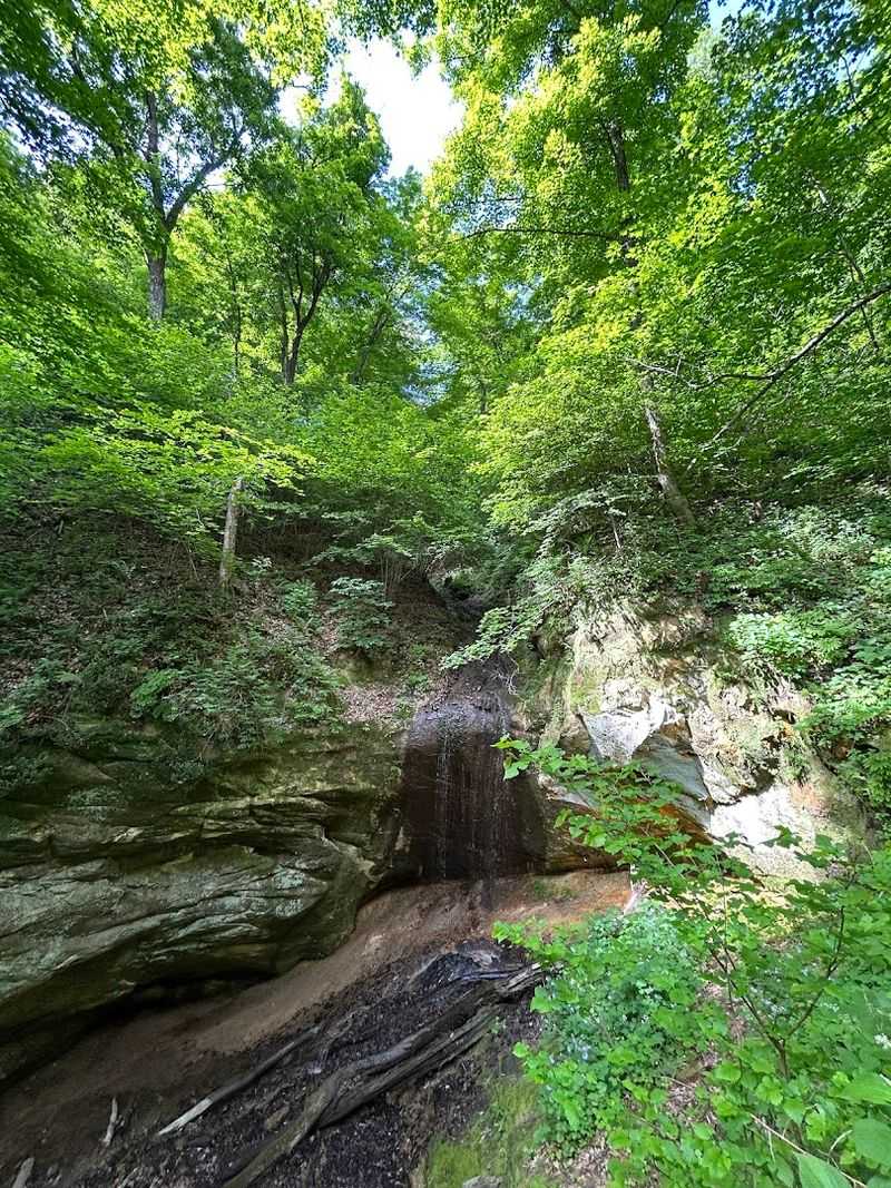
Water appears throughout the park in forms more delicate than the massive rivers below. Small springs emerge from the hillsides, trickling down through layers of limestone and sandstone.
These flows create microhabitats where moisture-loving plants thrive, adding green pockets to the drier upland forest.
The springs remain active even during dry summer months, fed by groundwater that percolates through the bluff geology. Their paths carve miniature valleys, sometimes disappearing underground before reemerging lower on the slope.
The sound of moving water accompanies many trail walks, a constant gentle backdrop to the larger silence.
Some springs have formed small pools where they encounter resistant rock layers. These collecting spots attract wildlife, particularly during hot weather when other water sources diminish.
The springs also contribute to the overall humidity of the forest, creating conditions that support ferns, mosses, and shade-tolerant flowers that might not survive in drier upland settings.
Scenic Blufftop Views That Make Every Walk Feel Rewarding
Multiple overlooks punctuate the park’s trail system, each offering a distinct perspective on the river valleys below. Point Lookout draws the most visitors, but Pictured Rock Cave Bluff and Sentinel Ridge provide equally compelling vistas with fewer crowds.
The elevation change from blufftop to river level exceeds 500 feet, creating a genuine sense of height and exposure.
The views change dramatically with weather and season. Spring brings high water that fills the backwater channels, while autumn colors paint the opposite bluffs in orange and red.
Winter strips away the leaves, revealing the underlying topography and the full sweep of the landscape.
Benches appear at several overlooks, inviting extended contemplation of the scene. The bluff edges feature protective railings in places, though some sections remain unguarded, requiring caution.
Sunset draws people to these spots, when the western sky lights up behind the river and the water reflects the changing colors.
One Of Wisconsin’s Oldest State Parks With A Deep Sense Of History
Wisconsin designated Wyalusing as a state park in 1917, making it one of the oldest protected areas in the system. Long before that official recognition, indigenous peoples recognized the strategic and spiritual significance of these bluffs.
Effigy mounds still visible in the park date back more than a thousand years, shaped by cultures that understood the power of this landscape.
The park’s development in the early 20th century reflected the conservation movement’s growing influence. Stone shelters and overlook structures built by the Civilian Conservation Corps during the 1930s remain in use today.
These features blend into the landscape while providing practical amenities for visitors.
Walking through Wyalusing means moving through layers of human history. The rivers below served as highways for French explorers and fur traders.
The bluffs offered defensive positions and observation posts. Today’s trails follow routes that people have walked for centuries, connecting modern visitors to a much longer story of human presence in this corner of Wisconsin.
A Birdwatching Haven Along A Major Migration Route
The Mississippi River serves as a major flyway for migrating birds, and Wyalusing’s position along this route makes it a premier birdwatching destination. Bald eagles nest in the area year-round, their populations swelling in winter when open water below the dams attracts hundreds of individuals.
Watching these massive birds ride thermals along the bluff face never loses its impact.
Spring and fall migrations bring warblers, thrushes, and other songbirds through the forest in waves. The varied habitat, from river bottomland to upland oak forest, supports different species and increases the diversity visitors might encounter.
Patient observers with binoculars can tally impressive species lists during peak migration weeks.
The backwater areas below the bluffs attract waterfowl and wading birds. Great blue herons stalk the shallows while wood ducks nest in tree cavities along the quieter channels.
Turkey vultures soar along the ridgelines, and the forest echoes with the calls of woodpeckers working the mature trees.
Peaceful Campsites Surrounded By Forest And River Views
The Wisconsin Ridge campground occupies some of the most scenic terrain in the park, with many sites positioned along the bluff edge. Campers can watch the sun rise over the river from their picnic tables, and the evening sky puts on a show most nights.
The sites offer a mix of sun and shade, with mature trees providing canopy without completely blocking the views.
Modern amenities balance the wilderness setting. The shower buildings feature good water pressure and hot water, with push-button controls that require periodic reactivation but deliver reliable results.
Flush toilets and vault facilities appear throughout the campground, and the spacing between sites provides reasonable privacy despite the open layout.
The Homestead campground sits lower in the park, offering a different experience with more seclusion and deeper forest. Both areas fill quickly during summer weekends, with reservations opening far in advance.
Fall camping brings fewer crowds and spectacular color, while spring offers solitude punctuated by birdsong and emerging wildflowers.
Easy Access To The Water For Canoeing And Kayaking Adventures
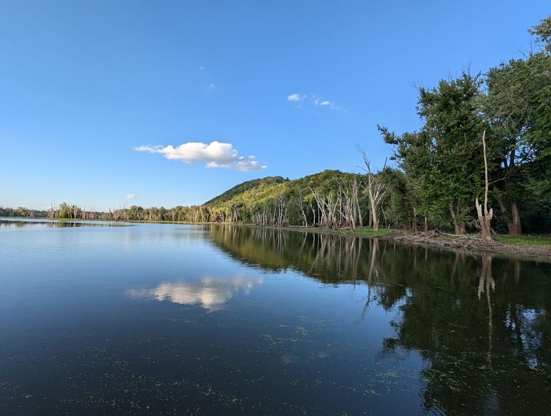
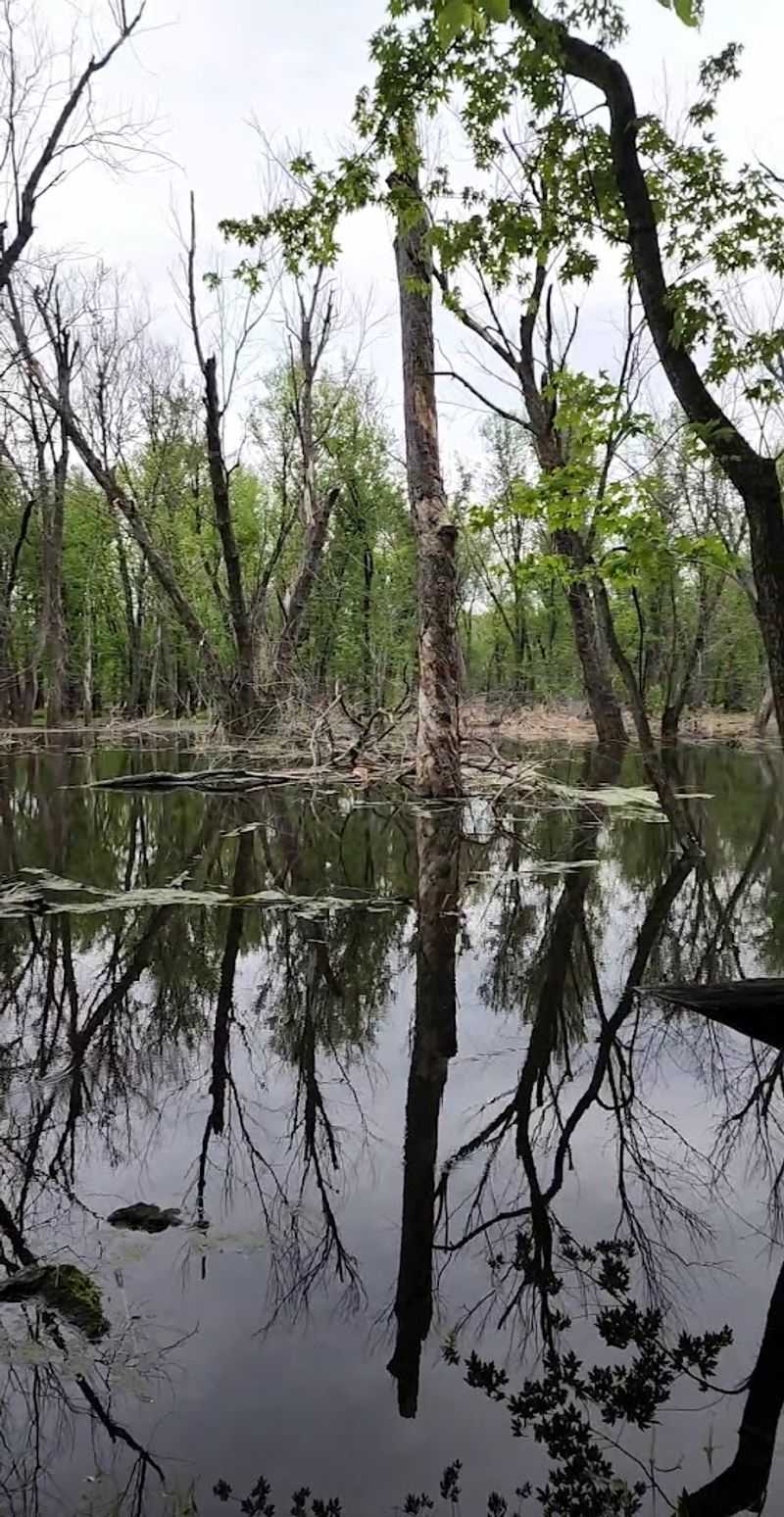
A boat launch provides direct access to the backwater areas of the Mississippi, opening up a different perspective on the park. The protected channels behind the islands offer calm water ideal for paddling, with minimal current and abundant wildlife viewing opportunities.
Canoe and kayak rentals operate from the concession stand during summer months, making it easy to get on the water without hauling your own boat.
The paddling routes wind through a maze of channels, sloughs, and small lakes created by the river’s complex hydrology. Lily pads cover some areas in summer, while open water elsewhere allows longer sightlines.
The shorelines support lush vegetation, and the shallow water makes it easy to observe fish, turtles, and aquatic plants.
Guided morning paddles sometimes run through the park naturalist program, offering interpretation of the backwater ecology. The still morning air and low light create ideal conditions for seeing herons, egrets, and other water birds.
The experience provides a counterpoint to the blufftop hiking, showing the park from water level where the scale and character of the landscape shift completely.
A Network Of Trails Suitable For Both Casual Walks And Longer Hikes
Trail options range from short nature walks to challenging full-day hikes, accommodating different fitness levels and time constraints. The Sentinel Ridge Trail offers an easy stroll to excellent views, covering less than a mile round trip.
The Bluff Trail presents a more serious challenge, following the cliff edge with narrow sections and significant exposure that demands attention and sure footing.
The Sand Cave trails descend into valleys carved by seasonal streams, passing rock formations and small caves formed by erosion. These routes involve considerable elevation change, with switchbacks easing but not eliminating the climb back to the ridgetop.
The Sugar Maple Trail leads to Pictured Rock Cave, combining forest walking with geological interest and a moderate workout.
Trail conditions vary seasonally, with spring bringing mud and late summer offering the driest footing. The park maintains the paths well, clearing fallen trees and marking junctions clearly.
Combining different trails creates loop options that can fill several hours, and the variety ensures that repeat visitors can always find something new to explore.
Seasonal Beauty That Changes The Experience Throughout The Year
Each season transforms Wyalusing into a different park. Spring brings wildflowers to the forest floor before the trees leaf out, with trilliums, bloodroot, and other ephemerals taking advantage of the brief window of sunlight.
The rivers run high with snowmelt, filling channels that may be dry by summer. Migrating birds pass through in waves, and the forest comes alive with returning songbirds.
Summer delivers full canopy and lush growth, with the forest at its greenest and most dense. The overlooks provide respite from the shade, and early morning or evening visits avoid the midday heat.
Thunderstorms roll through periodically, dramatic when viewed from the bluffs. Fall brings the park’s most famous display, with hardwood forests turning brilliant colors that stretch across the river valleys.
Winter strips the landscape to its essentials, revealing the underlying topography and opening up sightlines through the leafless forest. The park remains open, with trails available for snowshoeing and winter hiking.
Bald eagles concentrate along the open water below the dams, offering the year’s best viewing opportunities for these impressive raptors.