The Wisconsin Covered Bridge Hiding Deep In A National Forest That Most People Never Find
A forest road can change the whole mood of a trip, especially when it leads to something you did not expect. In Wisconsin, one quiet route brings travelers to a covered bridge that feels wonderfully out of place in the best way.
Timber beams, river sounds, and leafy views make the scene feel like it belongs on a postcard someone forgot to mail. It is not flashy, and that is part of the appeal.
Photographers get their angles, paddlers get a pretty river crossing, and curious drivers get a reason to slow down. The craftsmanship adds another layer, with newer construction shaped by older bridge-building traditions.
Little detours like this can make a drive feel memorable.
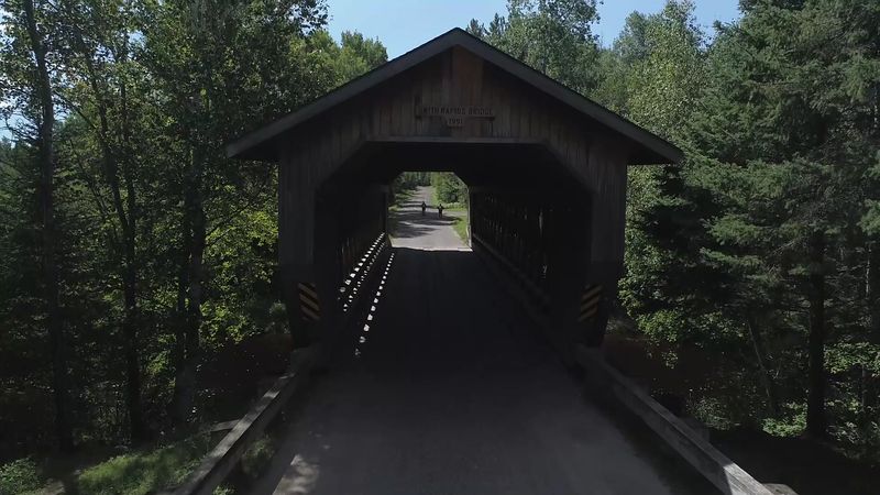
The Bridge Sits In The Chequamegon-Nicolet National Forest
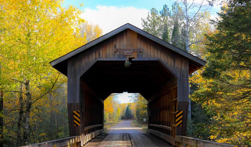
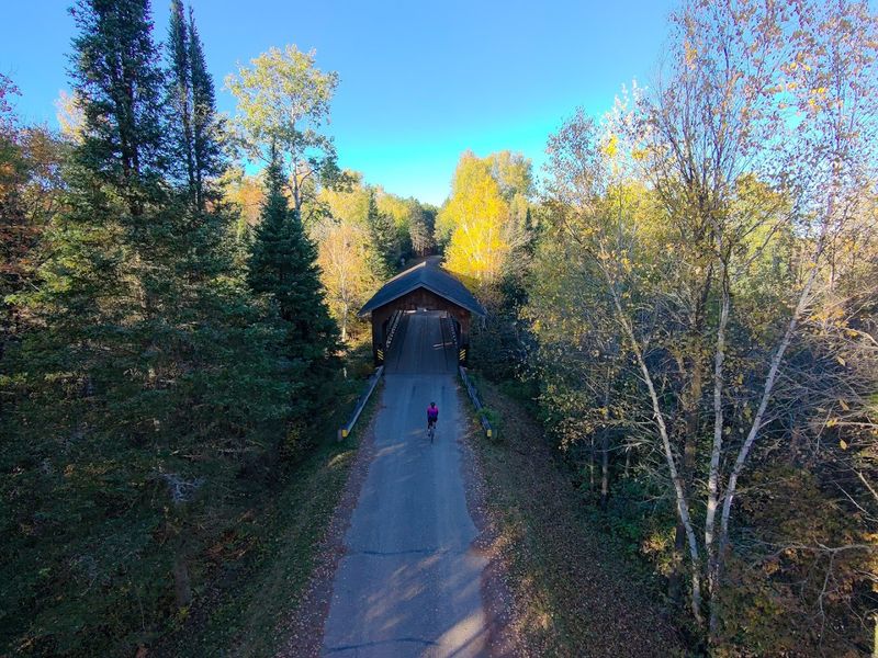
Located along Smith Rapids Road near Park Falls, the bridge occupies a section of forest that feels deliberately removed from everyday traffic. Visitors arrive after turning off Highway 70 and following a two-lane road that winds through stands of pine and hardwood.
The forest here maintains a quiet density, with little development to interrupt the canopy or the soundscape.
Open twenty-four hours every day, the site allows travelers to stop at any hour without gate restrictions or entry fees. The bridge itself functions as both a crossing and a destination, drawing people who appreciate functional design set within undisturbed woodland.
Picnic tables and an outhouse provide basic amenities near the structure.
Parking areas on either side of the bridge accommodate small groups, though the location rarely sees crowding even during peak summer months. The forest service maintains the road and immediate surroundings, keeping the area accessible for standard vehicles year-round.
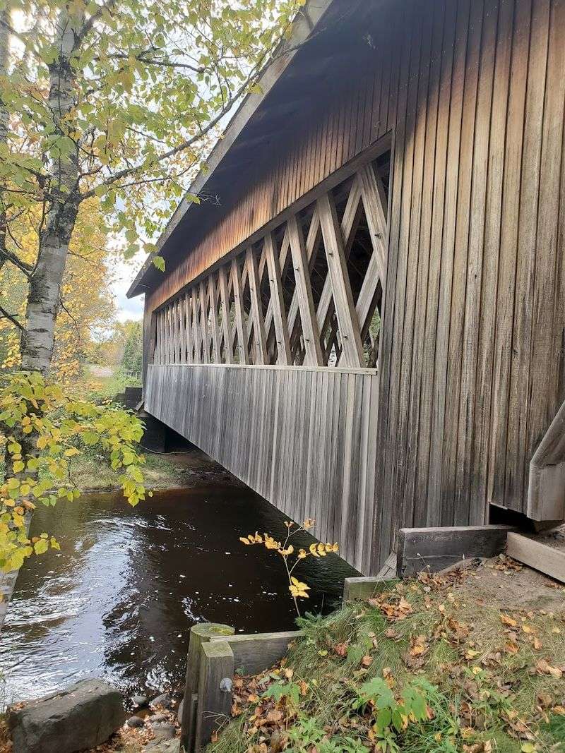
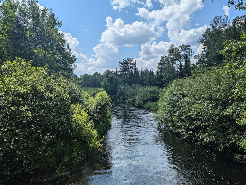
It Crosses The South Fork Of The Flambeau River
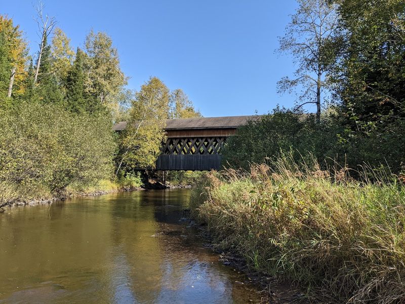
The South Fork of the Flambeau River runs beneath the bridge with a steady current that varies by season. During spring melt, the water moves quickly over a rocky bed visible from the bridge deck.
By late summer, the flow calms, revealing more of the riverbed and creating shallow pools along the banks.
Anglers occasionally work the river for trout, wading carefully among the stones that line the channel. The water remains cold throughout the year, fed by upstream tributaries that drain the surrounding forest.
From the bridge, you can watch the river bend upstream and disappear into a corridor of overhanging trees.
Photographers favor the view from the riverbank, where the bridge frame contrasts with the natural setting. The sound of moving water provides constant background noise, louder after heavy rain and softer during dry stretches.
The river itself adds purpose to the bridge, making the structure more than a decorative feature.
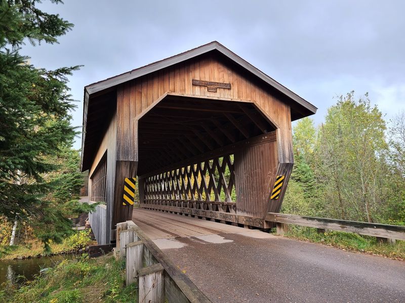
The Bridge Was Built In 1991
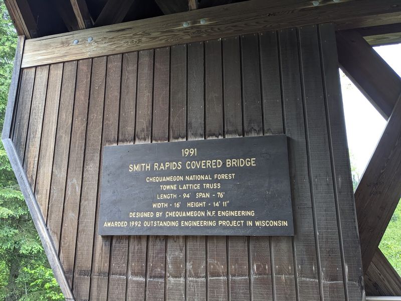
Construction took place in 1991, making this bridge far younger than the weathered structures often associated with covered design. The Forest Service commissioned the project as part of a broader effort to honor traditional bridge-building methods while meeting modern transportation needs.
Despite its recent origin, the bridge follows historical patterns in both form and material selection.
Builders used native timber and hand-fitted joinery techniques that replicate methods from the nineteenth century. The result is a structure that looks older than its actual age, particularly after three decades of weathering and use.
Some visitors express surprise upon learning the bridge’s true construction date, expecting something built a century earlier.
The decision to build a covered bridge in the 1990s reflected a conscious choice to preserve regional character rather than install a standard concrete span. This approach gave the forest service a functional crossing that also serves as an educational example of timber engineering.
The bridge has since become a recognized landmark within the national forest system.
It Is One Of Wisconsin’s Few Remaining Covered Bridges
Wisconsin never had a large number of covered bridges compared to eastern states, and most that existed have long since been replaced or demolished. The Smith Rapids bridge represents one of only a handful still standing in the state, making it a notable example for anyone studying regional bridge history.
Its survival owes partly to its location within protected federal land, where preservation takes priority over modernization.
Other covered bridges in Wisconsin have fallen victim to flood damage, structural decay, or highway expansion projects that favored steel and concrete. The rarity of these structures increases the value of the Smith Rapids example, even though its construction date is relatively recent.
Historians and engineers visit specifically to document its design and condition.
For casual travelers, the bridge offers a chance to experience a type of structure that has become uncommon across the upper Midwest. The covered design protects the timber framework from weather exposure, extending the lifespan of the wood and reducing maintenance costs over time.
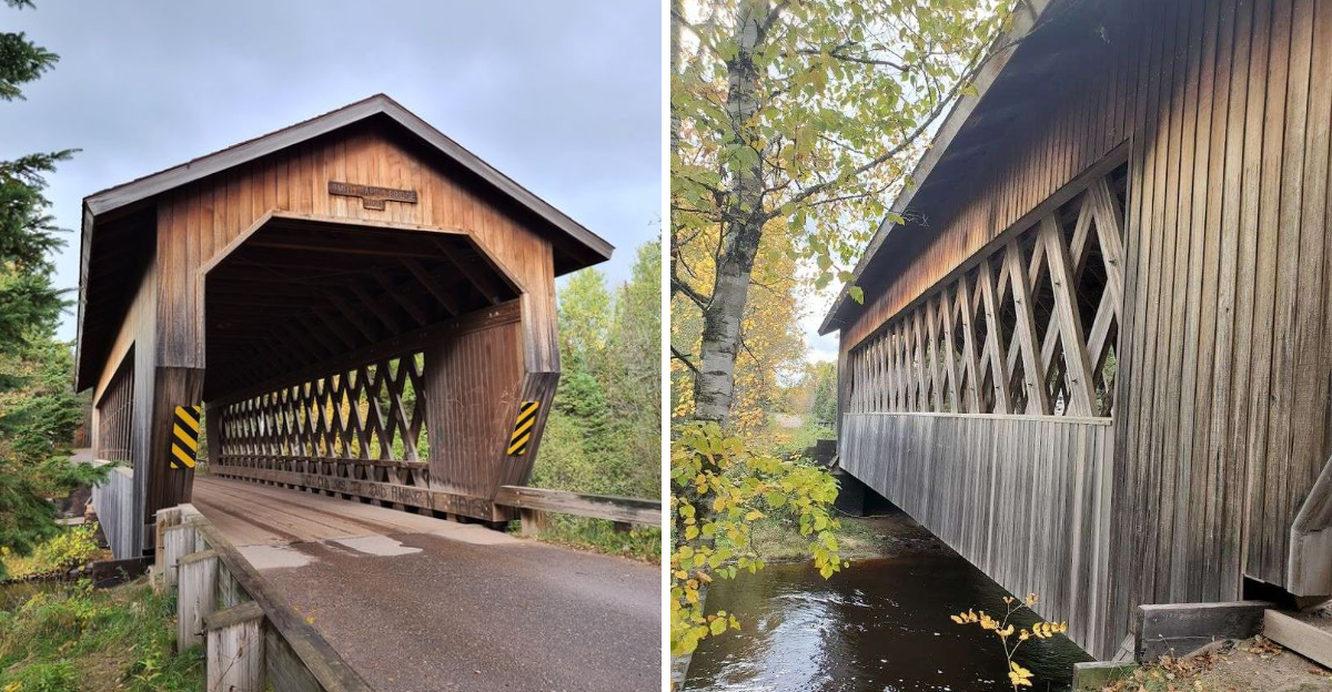
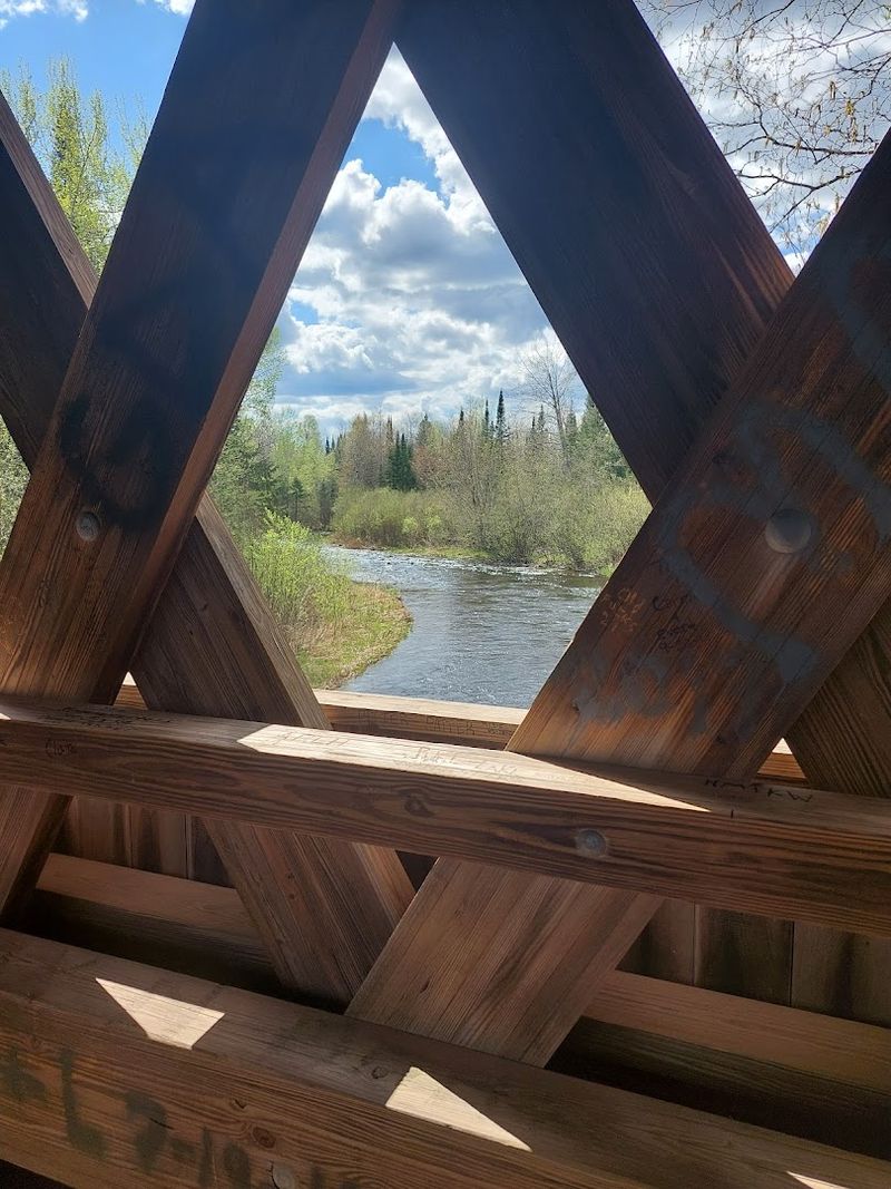
Its Lattice-Work Design Makes It Stand Out
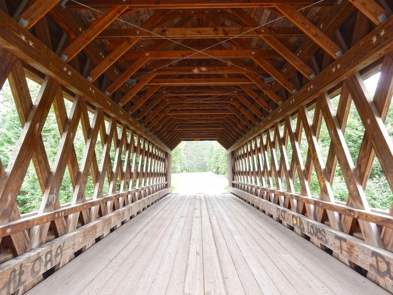
The bridge employs a lattice truss system, a design that uses diagonal wooden members arranged in a repeating diamond pattern along the sides. This method distributes weight efficiently across the span, allowing the structure to support vehicle traffic without requiring heavy steel reinforcement.
The lattice pattern creates visual interest, with light filtering through the gaps in a way that changes throughout the day.
Lattice trusses gained popularity in the nineteenth century for their strength-to-material ratio, making them economical for rural bridge projects. The Smith Rapids bridge follows this tradition, using lumber milled to precise dimensions and assembled with mortise-and-tenon joints.
The result is a structure that feels both sturdy and graceful, with the lattice work serving as both engineering solution and decorative element.
Visitors often pause to examine the joinery and wood grain visible in the lattice framework. The design allows for inspection and repair of individual members without dismantling the entire structure, a practical advantage that has helped maintain the bridge over its three decades of service.
The Bridge Won An Engineering Award In 1992
One year after completion, the bridge received recognition from engineering organizations for its successful integration of historical design principles with modern safety standards. The award acknowledged the skill required to build a lattice truss bridge using traditional methods while meeting contemporary load requirements and building codes.
This recognition brought attention to the project beyond the local area.
The engineering challenge involved calculating stress loads and material specifications that would satisfy federal standards without compromising the historical appearance of the structure. Designers worked with timber engineers and historians to ensure authenticity in both materials and construction techniques.
The finished bridge demonstrated that traditional methods could still produce safe, functional infrastructure.
The award also highlighted the Forest Service’s commitment to maintaining cultural and historical elements within recreational areas. For engineers and students of bridge design, the Smith Rapids structure serves as a case study in adaptive use of historical building methods.
The recognition has helped secure continued maintenance funding and public interest over the years.
Rustic Road 105 Leads Drivers Right To It
Rustic Road 105 provides the primary access route, following a paved but narrow roadway that winds through forest land for several miles. The road designation indicates a scenic byway maintained for its natural character rather than high-speed travel.
Drivers encounter curves, elevation changes, and close tree canopies that create a sense of immersion in the forest environment.
The route begins at Highway 70 and continues past the bridge into more remote sections of the national forest. Signage at the highway junction directs visitors toward the covered bridge, though the small size of the signs means some travelers pass without noticing.
The road surface remains in good condition year-round, though winter snow can accumulate quickly in shaded sections.
Traveling Rustic Road 105 adds to the experience of visiting the bridge, offering a slower pace and closer connection to the surrounding landscape. The road itself has become part of the attraction, with drivers often stopping at pullouts to photograph forest scenes or observe wildlife along the corridor.
The Nearby Smith Rapids Recreation Area Adds Picnic And River Access
Just beyond the bridge, the Smith Rapids Recreation Area provides a small campground and day-use facilities designed primarily for equestrian visitors. Picnic tables sit in clearings among the trees, offering spots to eat or rest after exploring the bridge and riverbank.
A hand-pumped well supplies drinking water, though visitors should come prepared with their own containers.
The recreation area connects to an extensive network of horse trails that wind through the surrounding forest. While the campground lacks electrical hookups or modern amenities, it attracts riders who value the quiet setting and direct trail access.
Hikers also use the area as a starting point for longer walks into the national forest.
River access points near the recreation area allow for fishing and wildlife observation along the South Fork. The combination of bridge, picnic facilities, and river proximity makes the site suitable for several hours of exploration.
Basic facilities keep the area functional without overwhelming the natural setting.
The South Fork Of The Flambeau River Is Popular For Canoeing
Paddlers use the South Fork as a route through the national forest, launching upstream and taking out at various access points downstream. The river offers a mix of gentle current and occasional rapids that require basic paddling skills but remain accessible to intermediate canoeists.
Water levels fluctuate seasonally, with spring providing the most reliable flow and summer sometimes requiring careful route selection around shallow sections.
The covered bridge serves as a recognizable landmark along the route, helping paddlers gauge their progress and providing a sheltered rest spot during rainy weather. Some canoeists plan trips specifically to pass beneath the structure, combining river travel with historical sightseeing.
The banks near the bridge allow for easy access and brief exploration on foot.
Local outfitters occasionally guide groups through this section of river, pointing out the bridge and discussing its construction history. The combination of moving water, forest scenery, and architectural interest makes this stretch popular among photographers and nature enthusiasts who want variety in their paddling experience.
Forest Roads And Quiet Surroundings Make It Feel Remote
Despite being accessible by paved road and located relatively close to Highway 70, the bridge occupies a setting that feels genuinely isolated. The density of surrounding forest limits sightlines and muffles highway noise, creating an atmosphere of seclusion.
Cell phone reception drops to nothing in most areas around the bridge, reinforcing the sense of distance from modern connectivity.
Visitor numbers remain modest even during summer weekends, with only a handful of vehicles typically present at any given time. The lack of commercial development or nearby towns means the site maintains a quiet character throughout the year.
This remoteness appeals to travelers seeking a break from more crowded tourist destinations.
The forest roads that branch from the main route add to the feeling of exploration, inviting those with time to wander deeper into the national forest. The combination of functional infrastructure and undeveloped surroundings creates a balance that preserves both accessibility and wilderness character.
For many visitors, this quality of remoteness becomes the most memorable aspect of the experience.