
A Thousand-Year-Old Settlement Rises Out Of The Flat Delta Farmland Along This Quiet Illinois Highway
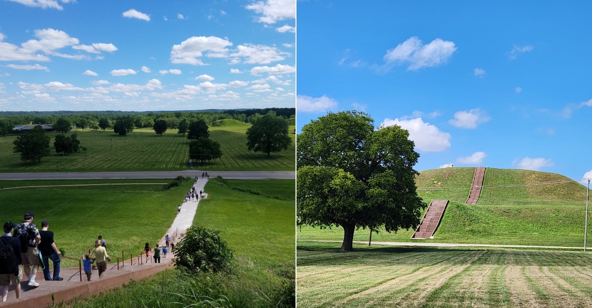
You might think you are looking at ordinary Illinois farmland until a massive grassy mound rises ahead. Suddenly, the flat landscape starts telling a story that reaches back more than a thousand years.
How did thousands of people build a thriving city here without modern machines or written records?
The answer unfolds along trails that pass ancient mounds, gathering places, and traces of a society archaeologists are still working to understand.
One enormous mound climbs high above the surrounding plain. From the top, the view stretches across the landscape and gives a whole new perspective on the scale of the settlement.
The experience goes beyond a quick roadside photo. Walk the trails, explore the grounds, and take time to imagine the busy community that once filled this landscape.
History feels surprisingly close here. All it takes is a comfortable pair of shoes and enough curiosity to follow the trail.
An Ancient Metropolis Hides Here
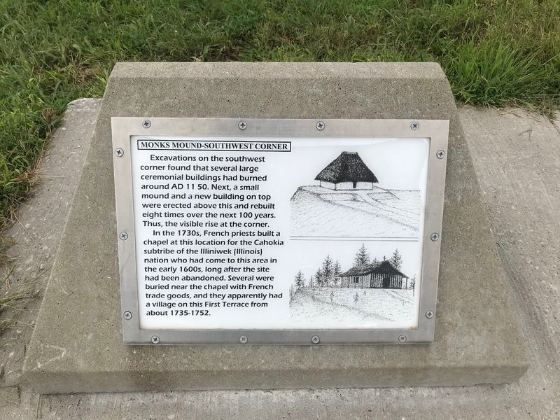
Welcome to Cahokia Mounds State Historic Site, the largest pre-Columbian settlement ever found north of Mexico. It sits in southwestern Illinois, minutes from the Mississippi River.
Archaeologists call the people who lived here the Mississippians. Their culture spread across river valleys and the southeastern United States, and this spot was the beating heart of it all.
Families settled the area mainly between A.D. 700 and 1400. Around A.D. 1050 to 1200, the population likely reached 10,000 to 20,000 people.
Counting the surrounding communities, some estimates for Greater Cahokia climb as high as 40,000 to 50,000.
Think about that for a moment. A city that size, in that era, rivaled major European capitals.
The original settlement stretched across more than 4,000 acres and held roughly 120 earthen mounds. About 70 to 80 survive inside the protected historic site today, each one shaped basket by basket using human muscle alone.
UNESCO added the place to its World Heritage list because nothing else quite matches it. No wheels, no draft animals, no iron tools.
Just planning, organization, and staggering effort.
Standing at the edge of the Grand Plaza, the scale sinks in slowly. Houses once lined the open ground.
Smoke rose from cooking fires. Traders arrived carrying copper, seashells, and stone from far away.
Can you imagine a city this busy existing here, a thousand years before highways crossed Illinois?
Climb The Continent’s Biggest Mound
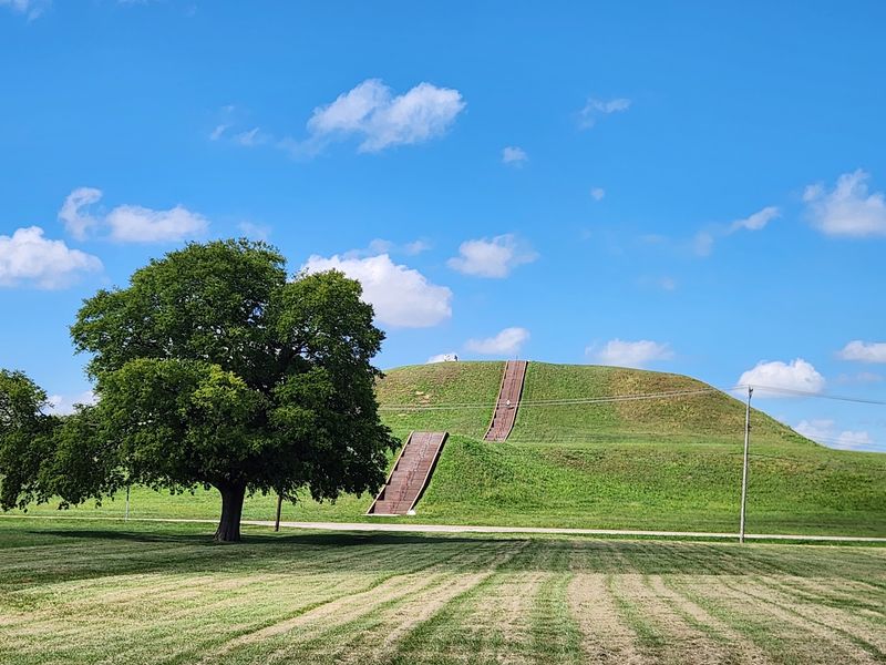
Some landmarks demand a climb, and Monks Mound is one of them. It is the largest indigenous earthen structure in the Americas north of Mexico.
The mound rises 100 feet, about the height of a ten-story building. Its base covers roughly 14 acres, a footprint bigger than the Great Pyramid of Giza.
Builders shaped it in 14 separate stages. Recent research suggests the work happened surprisingly fast, over just a few decades between about 900 and 955 CE.
Workers hauled an estimated 22 million cubic feet of soil in woven baskets. The dirt came from nearby borrow pits, low spots you can still spot on the landscape.
On top, four broad terraces once supported a large wooden building. Archaeologists believe it served as a temple, a leader’s residence, or possibly both.
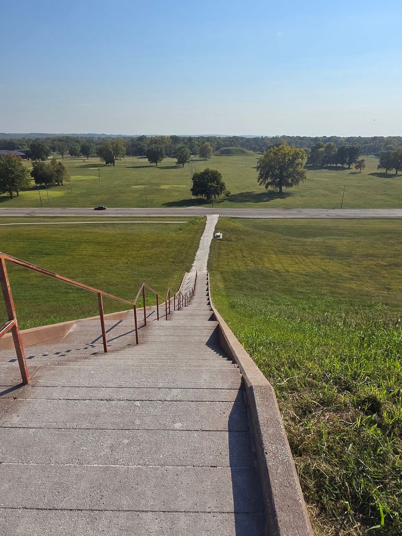
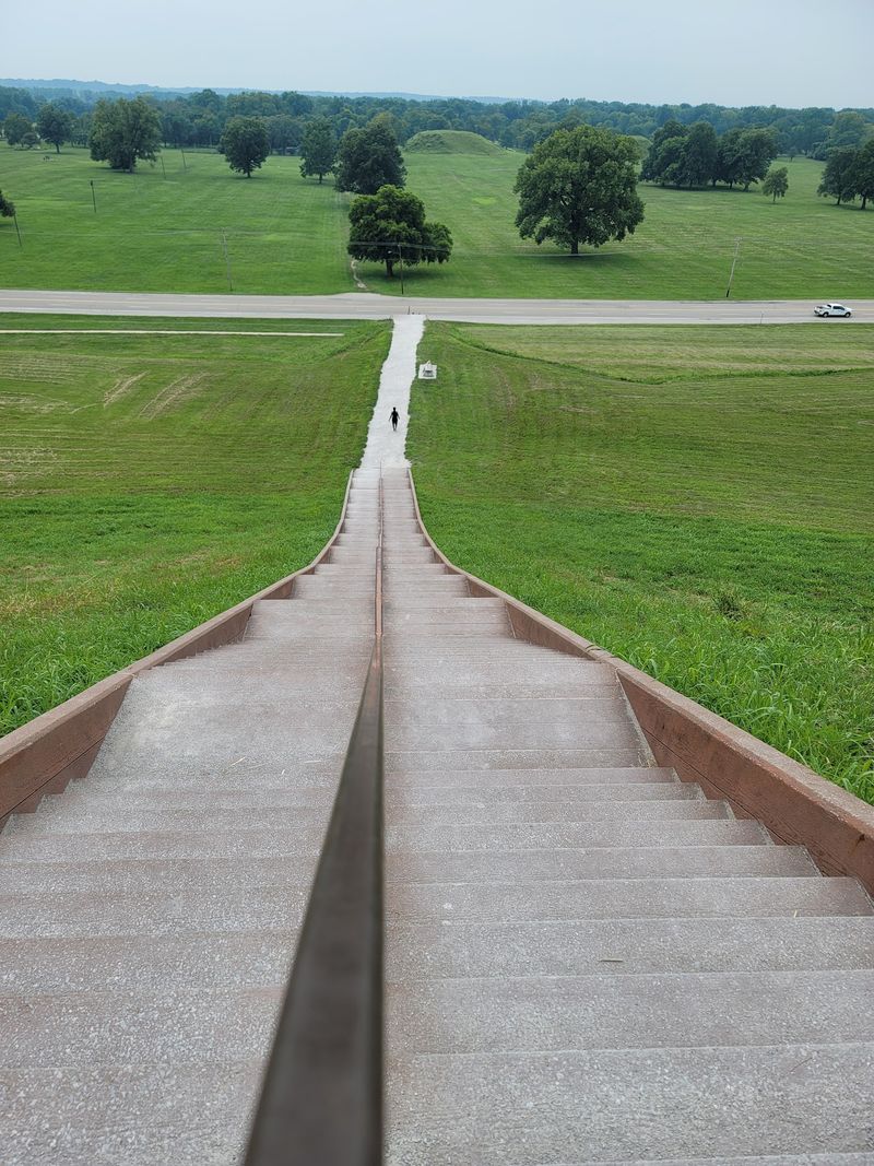
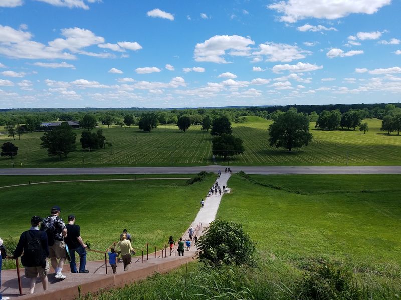
A modern staircase now runs up the south side, so the climb is manageable for most visitors. Take breaks.
The steps are steep, and the view improves with every pause.
From the summit, the flat Illinois farmland spreads out in all directions. On clear days, the Gateway Arch glints on the horizon across the river.
Morning light and late afternoon shade make the best photos. Wind up there can be strong, so hold onto hats.
How many baskets of earth do you think one person could carry in a single day?
Wooden Posts Track The Sun
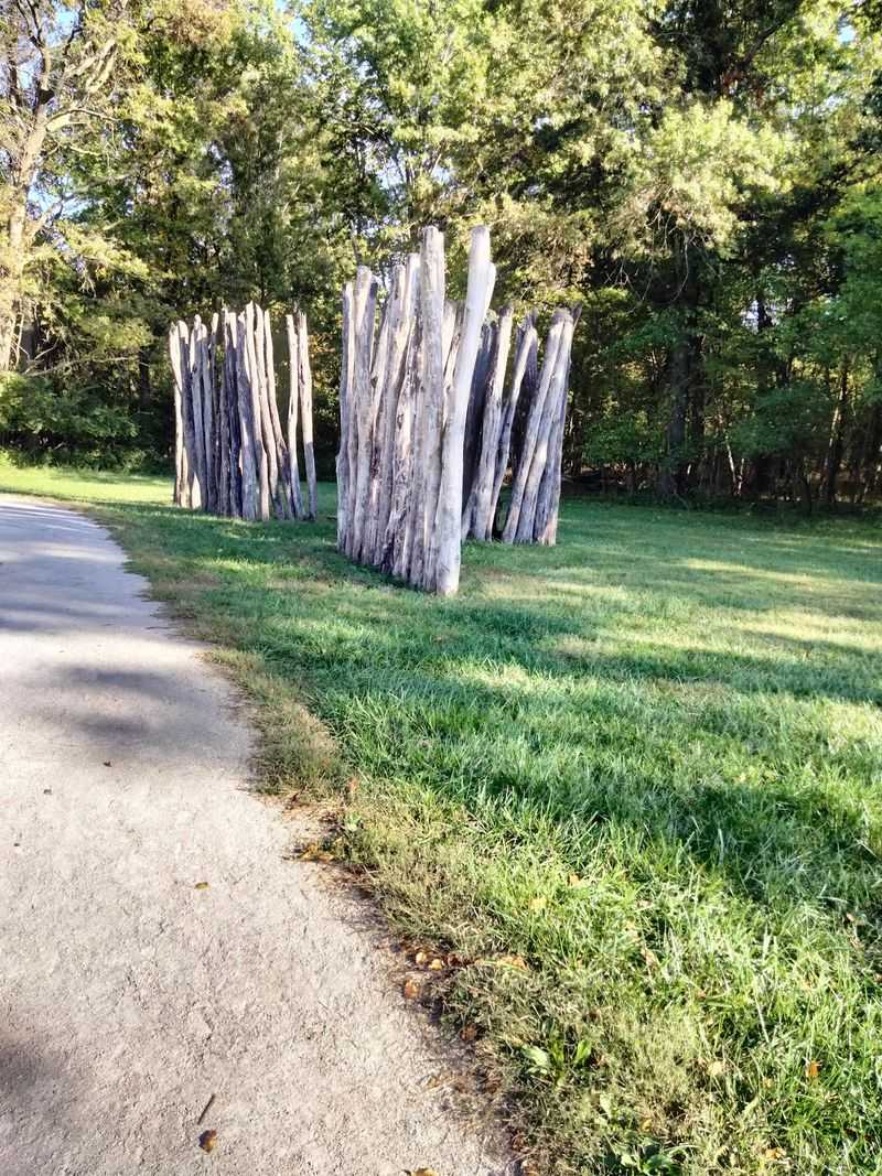
West of the great mound stands a circle of tall wooden posts. Archaeologists named it Woodhenge, and it worked as an astronomical calendar.
The posts line up with key moments in the sky. Sunrise on the summer and winter solstices, plus the spring and autumn equinoxes, all register against specific markers.
Five different Woodhenge circles have been identified at the site. Crews built and rebuilt them between roughly 900 and 1100 CE, changing the size and the number of posts each time.
Red cedar supplied the timber, a wood many Native American groups consider sacred. Traces of red ochre found in the ground hint that some posts may have been painted.
Picture a leader standing at the center, watching the sun climb over a distant post, announcing the turn of the season to a waiting crowd. Planting schedules and ceremonies likely depended on it.
The reconstruction you see today sits in open grass, easy to walk around and photograph. Early morning light through the posts looks especially striking.
Public sunrise observations still take place at the equinoxes and solstices each year. Checking the site calendar ahead of time helps, since these gatherings happen on specific dates.
Some researchers think the same sky alignments guided the layout of the entire city.
Meet A Vanished Everyday World
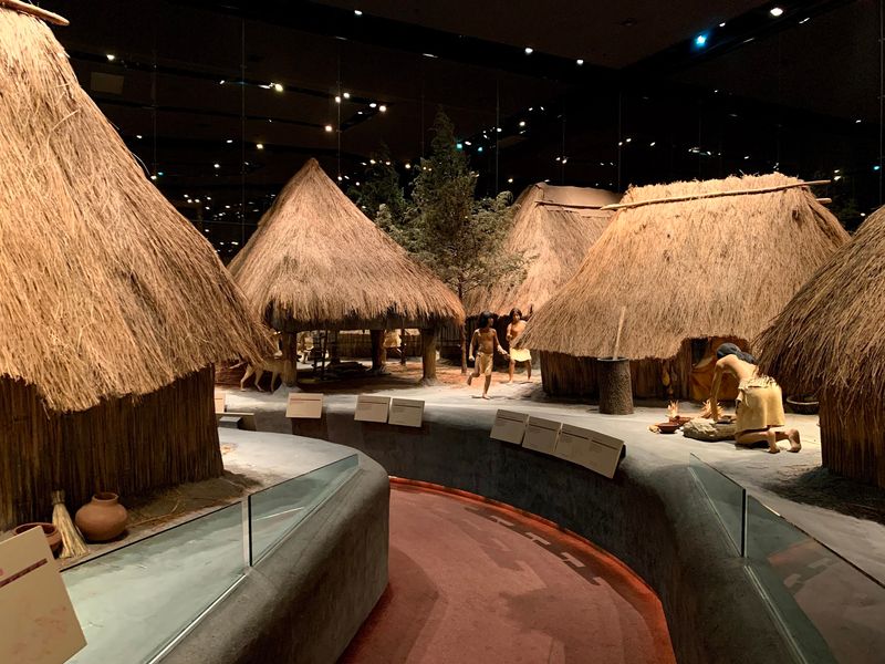
Mounds alone can feel mysterious. The Interpretive Center fills in the human details, and it makes the rest of the visit click into place.
Inside, life-size dioramas recreate a Mississippian neighborhood. Figures grind corn, tend fires, work hides, and play games while replica houses line a village lane.
Exhibits explain the architecture too. Walls of woven saplings, thatched roofs, and sunken floors kept homes warm through cold Illinois winters.
A theater shows an award-winning orientation film called City of the Sun. Watching it first gives useful context before you head outdoors.
Displays examine what made this settlement a true urban center. It served as a religious site, a political capital, a trading hub, and a cultural crossroads all at once.
Artifacts tell quieter stories. Pottery, arrow points, shell beads, and stone tools reveal skilled hands and long-distance trade networks reaching to the Gulf Coast and the Great Lakes.
A large site model helps you understand the layout before walking it. The canoe exhibit is another favorite stop.
Major exhibit renovations have been underway, so some areas may be limited. Checking the official website before your trip saves disappointment.
Plan about an hour to an hour and a half indoors. Restrooms and a gift shop sit right there as well.
Which everyday object would surprise you most in a thousand-year-old home?
Walk Miles Of Open Trails
Good news for walkers: the grounds here are made for wandering. Miles of trails thread between mounds, plazas, and quiet stretches of prairie and woodland.
A 3.5-mile loop attracts hikers and birdwatchers. Red-winged blackbirds, hawks, and songbirds are common company along the way.
Prefer something shorter? A paved three-quarter-mile accessible loop covers key highlights without a long trek.
The outdoor grounds and trails stay open daily from dawn until dusk. That generous window makes sunrise and sunset visits possible.
Self-guided touring is simple. Maps and brochures wait at the Monks Mound parking lot and in front of the Interpretive Center, and audio tours and guidebooks are available for loan or purchase.
Numbered stops explain what you are seeing. Without them, a grassy rise looks like a hill instead of a ceremonial platform or a burial mound.
Leashed pets are welcome on the grounds, so the family dog can join the adventure. Bring water for both of you.
Shade is limited in places. Summer visits go better with a hat, sunscreen, and an early start.
Spring and fall bring mild weather and beautiful light across the fields. Winter strips away the leaves and reveals mound shapes more clearly.
What will catch your eye first along these ancient pathways?
A Wooden Wall Once Stood
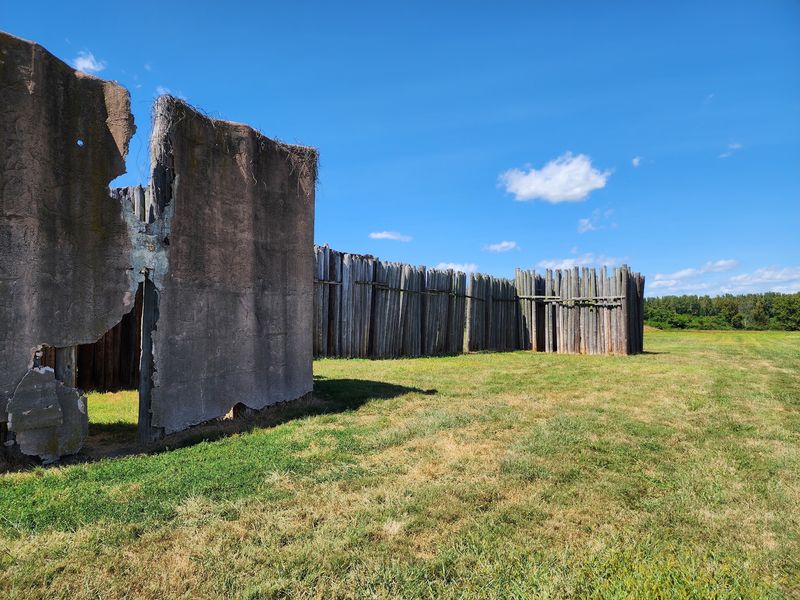
Cities protect themselves, and this one was no exception. A massive wooden stockade once wrapped around the most important central spaces.
A reconstructed section stands on the grounds today. Seeing those tall upright logs in person gives the defenses real weight.
Archaeological evidence points to four separate palisade walls, each roughly two miles long. Crews rebuilt them over time, which means the effort was repeated again and again.
Consider the logistics. Thousands of logs had to be cut, moved, trimmed, and set upright in trenches, all without metal tools or wheels.
The wall enclosed prominent public areas, including the great mound and the Grand Plaza. That choice tells us those spaces mattered enormously.
Researchers still debate the purpose. Defense against rivals seems likely, though the barrier may also have separated sacred ground from ordinary neighborhoods.
Bastions spaced along the wall suggest lookouts or archery platforms. Whoever designed it understood how to control approaches.
Stand beside the reconstruction and look back toward the mound. The sightline hints at how a visitor from far away might have felt arriving here for the first time.
The spot photographs well in late afternoon, when long shadows stripe the grass. It is also a quieter corner of the site, good for a slow pause.
Questions Archaeologists Still Cannot Answer
Here is the part that keeps visitors thinking on the drive home. Nobody knows for certain why this thriving city emptied out.
The decline unfolded gradually, with the settlement slowly abandoned between about 1300 and 1500 CE. By the time Europeans arrived, the mounds stood silent.
Theories pile up. Environmental change, depleted firewood and farmland, shifting climate, social conflict, and warfare all appear in the research.
Because the Mississippians left no written records, their beliefs and daily conversations remain out of reach. Everything we know comes from what they buried, built, and dropped.
Even the name is borrowed. Cahokia refers to a much later tribe living nearby, not the original residents.
Exhibits inside the Interpretive Center display the clues archaeologists work from. Pottery shards, projectile points, copper pieces, and shell ornaments sit in cases with panels explaining what each object suggests.
New discoveries still arrive. Ongoing excavations and modern technology keep adjusting the timeline and the population estimates.
That unfinished quality makes the visit feel alive rather than museum-quiet. You are looking at an open investigation, not a closed book.
Talk with staff at the desk if you enjoy this side of history. They often share which research questions are currently active.
Roughly 99 percent of the site remains unexcavated.
Smart Tips Before You Go
A little planning turns this stop into a highlight of any Illinois road trip. Most visitors need a half day, though a full day rewards the curious.
Budget about one to one and a half hours for the Interpretive Center. Add another one to two hours for walking the grounds and climbing the big mound.
Grounds and trails open daily from dawn until dusk. Indoor hours are narrower and have shifted during exhibit renovations, so confirm current times on the official Cahokia Mounds State Historic Site website before you drive over.
Comfortable shoes matter more than anything else here. Grass gets damp, and those summit stairs are no joke.
Pack water, sunscreen, and a light jacket. Open ground means open weather in every season.
Want a tech boost? An augmented reality app offers virtual tours of the Grand Plaza and the great mound, layering reconstructions over what you actually see.
Families do well starting indoors with the film, then heading out while energy is high. Picnic areas make a nice midday break.
The site sits just off Interstate highways near St. Louis, making it an easy detour for travelers crossing Illinois.
You will find this ancient city waiting at 30 Ramey St, Collinsville, IL 62234, where flat farmland suddenly turns into history.